Chester 180403 SityTrail > Percorsi > Outdoor > United Kingdom > Inghilterra > Cheshire West and Chester > Chester SityTrail > Percorsi > Outdoor > United Kingdom > Inghilterra > Cheshire West and Chester > Chester Chester 180403 JohnTompa Utente 3D © OpenStreetMap contributors Lunghezza 5,6 km Altitudine massima 35 m Dislivello positivo 41 m Km-Effort 6,1 km Altitudine minima 9 m Dislivello negativo 47 m Boucle Sì Data di creazione : 2019-05-02 17:48:59.569 Ultima modifica : 2019-05-02 17:48:59.616 (0 Recensione) Marcia 2h58 Difficoltà : Sconosciuto Applicazione GPS da escursionismo GRATUITA SityTrail IGN / Istituti geografici SityTrail World Il mondo è tuo Chi siamo 
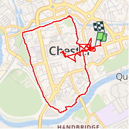
Percorso Marcia di 5,6 km da scoprire a Inghilterra, Cheshire West and Chester. Questo percorso è proposto da JohnTompa. Legende | Maggiori dettagli (PDF) Profilo altimetrico Legende > 15% 15% - 10% 10% - 5% di piatto 5% - 10% 10% - 15% 15% - 30% > 30% Localizzazione Paese: United Kingdom Regione : Inghilterra Dipartimento/Provincia : Cheshire West and Chester Comune : Chester Località : Unknown Partenza:(Dec) 53.191125 / -2.886639 Partenza:(UTM) 507574 ; 5893538 (30U) N. Commenti Accedi per lasciare un commento o una valutazione Percorsi nelle vicinanze GUIDE+ Canalside Trail A piedi Facile , Inghilterra, Cheshire West and Chester, United Kingdom 3,2 km | 3,6 km-effort 49min No