![](/images/other/stat-length.png)
![Percorso Marcia Linthal - Markstein 29/12/2016 - Photo](https://media.geolcdn.com/t/1900/400/ext.pjpeg?maxdim=2&url=https%3A%2F%2Fservices.sitytrail.com%2FGeolivesWS%2FDownloadMedia.ashx%3FTrailID%3D677915%26Media%3Dfix__20161229142930.jpg)
Markstein 29/12/2016
Richard68500
Utente
![Lunghezza](/images/other/stat-length.png)
Lunghezza
17,2 km
![Altitudine massima](https://static1.geolcdn.com/siteimages/upload/files/1508320355ic_sort_altitude_max_24dp.png)
Altitudine massima
1245 m
![Dislivello positivo](https://static1.geolcdn.com/siteimages/upload/files/1508320355ic_sort_den_pos_24dp.png)
Dislivello positivo
512 m
![Km-Effort](/images/other/stat-length.png)
Km-Effort
24 km
![Altitudine minima](https://static1.geolcdn.com/siteimages/upload/files/1508320355ic_sort_altitude_min_24dp.png)
Altitudine minima
935 m
![Dislivello negativo](https://static1.geolcdn.com/siteimages/upload/files/1508320355ic_sort_den_neg_24dp.png)
Dislivello negativo
506 m
![Boucle](https://static1.geolcdn.com/siteimages/upload/files/16400158638029165_repeat_loop_refresh_sync_direction_icon.png)
Boucle
Sì
Data di creazione :
2016-12-29 00:00:00.0
Ultima modifica :
2016-12-29 00:00:00.0
![Marcia](https://static1.geolcdn.com/sitytour/trail-icons/101.png)
5h11
Difficoltà : Medio
![Scannerizza questo codice QR per aprire il percorso nell'applicazione SityTrail](https://capi.geolives.com/qq0zvz2zws4bq2lad0pu/sitytour/trails/677915/qr.png?size=200)
Applicazione GPS da escursionismo GRATUITA
Chi siamo
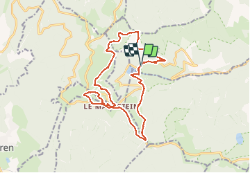
Percorso Marcia di 17,2 km da scoprire a Grande Est, Haut-Rhin, Linthal. Questo percorso è proposto da Richard68500.
Descrizione
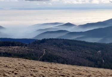
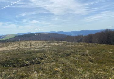
Belle balade sous le soleil, après une succulente escalope viennoise et une bonne bouteille de riesling offert par notre ami Francis pour ses 82 ans au restaurant Le Tremplin au Markstein mais malheureusement sans dessert...
Localizzazione
Paese:
France
Regione :
Grande Est
Dipartimento/Provincia :
Haut-Rhin
Comune :
Linthal
Località :
Unknown
Partenza:(Dec)
Partenza:(UTM)
354127 ; 5311129 (32T) N.
Commenti
Percorsi nelle vicinanze
![Percorso Marcia Linthal - Markstein - Photo](https://media.geolcdn.com/t/375/260/ext.jpg?maxdim=2&url=https%3A%2F%2Fservices.sitytrail.com%2FGeolivesWS%2FDownloadMedia.ashx%3FTrailID%3D266212%26Media%3Dfix__20140413115328.jpg)
![Marcia Marcia](https://static1.geolcdn.com/sitytour/trail-icons/101.png)
Markstein
Marcia
Medio
(1)
Linthal,
Grande Est,
Haut-Rhin,
France
![](/images/other/stat-length.png)
14 km | 19,8 km-effort
4h 45min
![](https://static1.geolcdn.com/siteimages/upload/files/16400158638029165_repeat_loop_refresh_sync_direction_icon.png)
Sì
![Percorso Marcia Linthal - Tour de la grande Vallée de Munster (refuge du Hilsen - Munster) - Photo](https://media.geolcdn.com/t/375/260/ext.jpg?maxdim=2&url=https%3A%2F%2Fservices.sitytrail.com%2FGeolivesWS%2FDownloadMedia.ashx%3FTrailID%3D173094%26Media%3D14636_4.jpg)
![Marcia Marcia](https://static1.geolcdn.com/sitytour/trail-icons/101.png)
Tour de la grande Vallée de Munster (refuge du Hilsen - Munster)
Marcia
Difficile
(1)
Linthal,
Grande Est,
Haut-Rhin,
France
![](/images/other/stat-length.png)
18,1 km | 24 km-effort
5h 0min
![](https://static1.geolcdn.com/siteimages/upload/files/16400158638029165_repeat_loop_refresh_sync_direction_icon.png)
No
![Percorso Marcia Lautenbachzell - Le Markstein - Photo](https://media.geolcdn.com/t/375/260/ext.jpg?maxdim=2&url=https%3A%2F%2Fservices.sitytrail.com%2FGeolivesWS%2FDownloadMedia.ashx%3FTrailID%3D109647%26Media%3D4288_1.jpg)
![Marcia Marcia](https://static1.geolcdn.com/sitytour/trail-icons/101.png)
Le Markstein
Marcia
Difficile
(1)
Lautenbachzell,
Grande Est,
Haut-Rhin,
France
![](/images/other/stat-length.png)
22 km | 35 km-effort
6h 0min
![](https://static1.geolcdn.com/siteimages/upload/files/16400158638029165_repeat_loop_refresh_sync_direction_icon.png)
Sì
![Percorso Marcia Linthal - SityTrail - Remspach-Hilsen - Photo](https://media.geolcdn.com/t/375/260/ext.jpg?maxdim=2&url=https%3A%2F%2Fstatic1.geolcdn.com%2Fsiteimages%2Fupload%2Ffiles%2F1553511878bg_sport_marche.png)
![Marcia Marcia](https://static1.geolcdn.com/sitytour/trail-icons/101.png)
SityTrail - Remspach-Hilsen
Marcia
Medio
(1)
Linthal,
Grande Est,
Haut-Rhin,
France
![](/images/other/stat-length.png)
9,9 km | 14,6 km-effort
3h 3min
![](https://static1.geolcdn.com/siteimages/upload/files/16400158638029165_repeat_loop_refresh_sync_direction_icon.png)
Sì
![Percorso A piedi Lautenbachzell - Parking Bellevue - Hundsrucken - Markstein - Photo](https://media.geolcdn.com/t/375/260/ext.jpg?maxdim=2&url=https%3A%2F%2Fstatic1.geolcdn.com%2Fsiteimages%2Fupload%2Ffiles%2F1545311037marcheuse_200dpi.jpg)
![A piedi A piedi](https://static1.geolcdn.com/sitytour/trail-icons/100.png)
Parking Bellevue - Hundsrucken - Markstein
A piedi
Medio
(1)
Lautenbachzell,
Grande Est,
Haut-Rhin,
France
![](/images/other/stat-length.png)
9,4 km | 13 km-effort
Sconosciuto
![](https://static1.geolcdn.com/siteimages/upload/files/16400158638029165_repeat_loop_refresh_sync_direction_icon.png)
Sì
![Percorso Marcia Sondernach - 2020-01-02 Marche Landersen Petit Ballon - Photo](https://media.geolcdn.com/t/375/260/ext.jpg?maxdim=2&url=https%3A%2F%2Fmedia.geolcdn.com%2Ff%2Fabff8abb-ba88-42b9-b3e3-f376b36342fa.jpg)
![Marcia Marcia](https://static1.geolcdn.com/sitytour/trail-icons/101.png)
2020-01-02 Marche Landersen Petit Ballon
Marcia
Difficile
Sondernach,
Grande Est,
Haut-Rhin,
France
![](/images/other/stat-length.png)
17,6 km | 28 km-effort
3h 4min
![](https://static1.geolcdn.com/siteimages/upload/files/16400158638029165_repeat_loop_refresh_sync_direction_icon.png)
Sì
![Percorso Mountainbike Metzeral - Breitfirst - Petit Ballon - Col de Firstplan - Wintzenheim - Photo](https://media.geolcdn.com/t/375/260/ext.jpg?maxdim=2&url=https%3A%2F%2Fstatic1.geolcdn.com%2Fsiteimages%2Fupload%2Ffiles%2F1524743154velo.jpg)
![Mountainbike Mountainbike](https://static1.geolcdn.com/sitytour/trail-icons/202.png)
Breitfirst - Petit Ballon - Col de Firstplan - Wintzenheim
Mountainbike
Medio
(1)
Metzeral,
Grande Est,
Haut-Rhin,
France
![](/images/other/stat-length.png)
38 km | 52 km-effort
3h 11min
![](https://static1.geolcdn.com/siteimages/upload/files/16400158638029165_repeat_loop_refresh_sync_direction_icon.png)
No
![Percorso Marcia Metzeral - 24 04 14 autour d’Uffrain - Photo](https://media.geolcdn.com/t/375/260/ext.jpg?maxdim=2&url=https%3A%2F%2Fmedia.geolcdn.com%2Ff%2F5d272a7d-046b-44ac-82c1-096c8c22e6f1.jpg)
![Marcia Marcia](https://static1.geolcdn.com/sitytour/trail-icons/101.png)
24 04 14 autour d’Uffrain
Marcia
Metzeral,
Grande Est,
Haut-Rhin,
France
![](/images/other/stat-length.png)
70 km | 83 km-effort
3h 45min
![](https://static1.geolcdn.com/siteimages/upload/files/16400158638029165_repeat_loop_refresh_sync_direction_icon.png)
No
![Percorso Marcia Soultz-Haut-Rhin - Mon tour des Vosges (4 jours) - Photo](https://media.geolcdn.com/t/375/260/ext.jpg?maxdim=2&url=https%3A%2F%2Fmedia.geolcdn.com%2Ff%2Fba3218f4-756e-4505-86a8-6b6690bf13fc.JPG)
![Marcia Marcia](https://static1.geolcdn.com/sitytour/trail-icons/101.png)
Mon tour des Vosges (4 jours)
Marcia
Molto difficile
Soultz-Haut-Rhin,
Grande Est,
Haut-Rhin,
France
![](/images/other/stat-length.png)
71 km | 113 km-effort
25h 38min
![](https://static1.geolcdn.com/siteimages/upload/files/16400158638029165_repeat_loop_refresh_sync_direction_icon.png)
Sì