![](/images/other/stat-length.png)
![Percorso A piedi Unknown - Prezid - Čabar - Tršće - Photo](https://media.geolcdn.com/t/1900/400/63396e8a-0219-4975-8a92-2dc12ba77793.jpeg&format=pjpeg&maxdim=2)
Prezid - Čabar - Tršće
SityTrail - itinéraires balisés pédestres
Tous les sentiers balisés d’Europe GUIDE+
![Lunghezza](/images/other/stat-length.png)
![Altitudine massima](https://static1.geolcdn.com/siteimages/upload/files/1508320355ic_sort_altitude_max_24dp.png)
![Dislivello positivo](https://static1.geolcdn.com/siteimages/upload/files/1508320355ic_sort_den_pos_24dp.png)
![Km-Effort](/images/other/stat-length.png)
![Altitudine minima](https://static1.geolcdn.com/siteimages/upload/files/1508320355ic_sort_altitude_min_24dp.png)
![Dislivello negativo](https://static1.geolcdn.com/siteimages/upload/files/1508320355ic_sort_den_neg_24dp.png)
![Boucle](https://static1.geolcdn.com/siteimages/upload/files/16400158638029165_repeat_loop_refresh_sync_direction_icon.png)
![A piedi](https://static1.geolcdn.com/sitytour/trail-icons/100.png)
1h36
Difficoltà : Facile
![Scannerizza questo codice QR per aprire il percorso nell'applicazione SityTrail](https://capi.geolives.com/qq0zvz2zws4bq2lad0pu/sitytour/trails/4346116/qr.png?size=200)
Applicazione GPS da escursionismo GRATUITA
Chi siamo
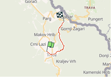
Percorso A piedi di 4,9 km da scoprire a Sconosciuto, Regione litoraneo-montana. Questo percorso è proposto da SityTrail - itinéraires balisés pédestres.
Descrizione
In the northern part of the region of Gorski kotar, north of the mountain area of Risnjak and the city of Delnice, there is a mountainous and forested area with the settlements of Gerovo, Čabar and Prezid as key centers. This area offers a sight of the most beautiful mountain oasis in that part ...
Sito web: https://trail.viadinarica.com/tour/hiking/15085364/
Localizzazione
Commenti
Percorsi nelle vicinanze
![Percorso A piedi - Tršće - Sveta gora - Izvor Kupe - Crni Lug - Photo](https://media.geolcdn.com/t/375/260/60013492-baa6-4369-bcba-b910bef47edc.jpeg&format=jpg&maxdim=2)
![A piedi A piedi](https://static1.geolcdn.com/sitytour/trail-icons/100.png)
A piedi
![](/images/other/stat-length.png)
![](https://static1.geolcdn.com/siteimages/upload/files/16400158638029165_repeat_loop_refresh_sync_direction_icon.png)