


7,7 km | 9,6 km-effort
![Percorso A piedi Krásná - [Z] Krásná - nejzápadnější bod ČR - Photo](https://media.geolcdn.com/t/1900/400/631889f3-3839-4731-be0e-23b816dd81e6.jpeg&format=pjpeg&maxdim=2)

Tous les sentiers balisés d’Europe GUIDE+


Applicazione GPS da escursionismo GRATUITA
 SityTrail
IGN / Istituti geografici
SityTrail World
Il mondo è tuo
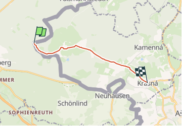
Percorso A piedi di 6,5 km da scoprire a Severozápad, Karlovarský kraj, Krásná. Questo percorso è proposto da SityTrail - itinéraires balisés pédestres.
Percorso creato da cz:KČT.
![Percorso A piedi Krásná - [Z] Krásná - nejzápadnější bod ČR - Photo 1](https://media.geolcdn.com/t/2048/auto/c47e84f8-5a97-4ea3-a836-af3ca5edf17a.jpeg&format=jpg&maxdim=0 "Percorso A piedi Krásná - [Z] Krásná - nejzápadnější bod ČR - Photo 1")
![Percorso A piedi Krásná - [Z] Krásná - nejzápadnější bod ČR - Photo 2](https://media.geolcdn.com/t/2048/auto/b5994b3c-bf86-46d8-a5ea-e4a4f1ce8e66.jpeg&format=jpg&maxdim=0 "Percorso A piedi Krásná - [Z] Krásná - nejzápadnější bod ČR - Photo 2")
![Percorso A piedi Krásná - [Z] Krásná - nejzápadnější bod ČR - Photo 3](https://media.geolcdn.com/t/2048/auto/d31f8070-e2a6-4ae8-8294-0cbd6472ffa9.jpeg&format=jpg&maxdim=0 "Percorso A piedi Krásná - [Z] Krásná - nejzápadnější bod ČR - Photo 3")
![Percorso A piedi Krásná - [Z] Krásná - nejzápadnější bod ČR - Photo 4](https://media.geolcdn.com/t/2048/auto/e472dbbd-669c-43fc-9650-df6f9eb6a51b.jpeg&format=jpg&maxdim=0 "Percorso A piedi Krásná - [Z] Krásná - nejzápadnější bod ČR - Photo 4")
![Percorso A piedi Krásná - [Z] Krásná - nejzápadnější bod ČR - Photo 5](https://media.geolcdn.com/t/2048/auto/cbdef4c8-465c-4115-ac4f-084e37ddb7c0.jpeg&format=jpg&maxdim=0 "Percorso A piedi Krásná - [Z] Krásná - nejzápadnější bod ČR - Photo 5")
![Percorso A piedi Krásná - [Z] Krásná - nejzápadnější bod ČR - Photo 6](https://media.geolcdn.com/t/2048/auto/b0552d7b-f1c4-454b-a260-54dba6f408d1.jpeg&format=jpg&maxdim=0 "Percorso A piedi Krásná - [Z] Krásná - nejzápadnější bod ČR - Photo 6")
![Percorso A piedi Krásná - [Z] Krásná - nejzápadnější bod ČR - Photo 7](https://media.geolcdn.com/t/2048/auto/b9c583ba-5c01-4200-9a67-6af204770b6d.jpeg&format=jpg&maxdim=0 "Percorso A piedi Krásná - [Z] Krásná - nejzápadnější bod ČR - Photo 7")
![Percorso A piedi Krásná - [Z] Krásná - nejzápadnější bod ČR - Photo 8](https://media.geolcdn.com/t/2048/auto/f8e1795f-3519-46a4-9b9b-c43cbf2286a2.jpeg&format=jpg&maxdim=0 "Percorso A piedi Krásná - [Z] Krásná - nejzápadnější bod ČR - Photo 8")
![Percorso A piedi Krásná - [Z] Krásná - nejzápadnější bod ČR - Photo 9](https://media.geolcdn.com/t/2048/auto/9add5b84-1286-41cc-86ed-0f650ac57d77.jpeg&format=jpg&maxdim=0 "Percorso A piedi Krásná - [Z] Krásná - nejzápadnější bod ČR - Photo 9")
![Percorso A piedi Krásná - [Z] Krásná - nejzápadnější bod ČR - Photo 10](https://media.geolcdn.com/t/2048/auto/631889f3-3839-4731-be0e-23b816dd81e6.jpeg&format=jpg&maxdim=0 "Percorso A piedi Krásná - [Z] Krásná - nejzápadnější bod ČR - Photo 10")

A piedi

A piedi
A piedi
A piedi
A piedi
A piedi

A piedi
A piedi