![](/images/other/stat-length.png)
![Percorso A piedi Loučovice - [Ž] Kapličky - Mnichovice - Photo](https://media.geolcdn.com/t/1900/400/1772f7d3-364c-4f12-bb68-2d31ffa4b776.jpeg&format=pjpeg&maxdim=2)
[Ž] Kapličky - Mnichovice
SityTrail - itinéraires balisés pédestres
Tous les sentiers balisés d’Europe GUIDE+
![Lunghezza](/images/other/stat-length.png)
Lunghezza
7,8 km
![Altitudine massima](https://static1.geolcdn.com/siteimages/upload/files/1508320355ic_sort_altitude_max_24dp.png)
Altitudine massima
1015 m
![Dislivello positivo](https://static1.geolcdn.com/siteimages/upload/files/1508320355ic_sort_den_pos_24dp.png)
Dislivello positivo
108 m
![Km-Effort](/images/other/stat-length.png)
Km-Effort
9,9 km
![Altitudine minima](https://static1.geolcdn.com/siteimages/upload/files/1508320355ic_sort_altitude_min_24dp.png)
Altitudine minima
730 m
![Dislivello negativo](https://static1.geolcdn.com/siteimages/upload/files/1508320355ic_sort_den_neg_24dp.png)
Dislivello negativo
314 m
![Boucle](https://static1.geolcdn.com/siteimages/upload/files/16400158638029165_repeat_loop_refresh_sync_direction_icon.png)
Boucle
No
Tag
Data di creazione :
2025-02-07 04:29:26.686
Ultima modifica :
2025-02-07 04:29:26.686
![A piedi](https://static1.geolcdn.com/sitytour/trail-icons/100.png)
2h15
Difficoltà : Facile
![Scannerizza questo codice QR per aprire il percorso nell'applicazione SityTrail](https://capi.geolives.com/qq0zvz2zws4bq2lad0pu/sitytour/trails/4344601/qr.png?size=200)
Applicazione GPS da escursionismo GRATUITA
Chi siamo
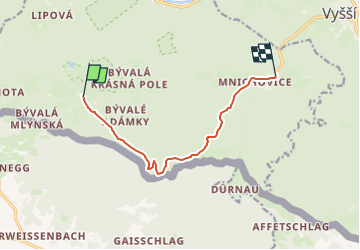
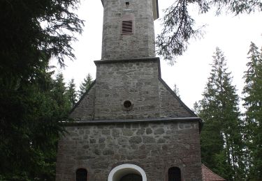
Percorso A piedi di 7,8 km da scoprire a Jihozápad, Jihočeský kraj, Loučovice. Questo percorso è proposto da SityTrail - itinéraires balisés pédestres.
Descrizione
Percorso creato da cz:KČT.
ends: Kapličky, Mnichovice
Localizzazione
Paese:
Czech Republic
Regione :
Jihozápad
Dipartimento/Provincia :
Jihočeský kraj
Comune :
Loučovice
Località :
Unknown
Partenza:(Dec)
Partenza:(UTM)
442300 ; 5382886 (33U) N.
Commenti
Percorsi nelle vicinanze
![Percorso A piedi Loučovice - [Ž] Vyšší Brod - Loučovice - Photo](https://media.geolcdn.com/t/375/260/81249ce9-5aee-4e68-9458-f6a14a4fc319.jpeg&format=jpg&maxdim=2)
![A piedi A piedi](https://static1.geolcdn.com/sitytour/trail-icons/100.png)
[Ž] Vyšší Brod - Loučovice
A piedi
Facile
Loučovice,
Jihozápad,
Jihočeský kraj,
Czech Republic
![](/images/other/stat-length.png)
7,4 km | 11 km-effort
2h 29min
![](https://static1.geolcdn.com/siteimages/upload/files/16400158638029165_repeat_loop_refresh_sync_direction_icon.png)
No
![Percorso A piedi Vorderweißenbach - Steinerne Mühl Weg - Photo](https://media.geolcdn.com/t/375/260/1248ec60-2e25-4827-a4c2-29736c88c1c6.jpeg&format=jpg&maxdim=2)
![A piedi A piedi](https://static1.geolcdn.com/sitytour/trail-icons/100.png)
Steinerne Mühl Weg
A piedi
Facile
Vorderweißenbach,
Oberösterreich,
Bezirk Urfahr-Umgebung,
Austria
![](/images/other/stat-length.png)
5,6 km | 7,5 km-effort
1h 42min
![](https://static1.geolcdn.com/siteimages/upload/files/16400158638029165_repeat_loop_refresh_sync_direction_icon.png)
Sì
![Percorso A piedi Vorderweißenbach - Wassersteig - Photo](https://media.geolcdn.com/t/375/260/c2f06a4d-c1eb-41e6-a2e6-b205d9183d3c.jpeg&format=jpg&maxdim=2)
![A piedi A piedi](https://static1.geolcdn.com/sitytour/trail-icons/100.png)
Wassersteig
A piedi
Facile
Vorderweißenbach,
Oberösterreich,
Bezirk Urfahr-Umgebung,
Austria
![](/images/other/stat-length.png)
5,2 km | 6,6 km-effort
1h 29min
![](https://static1.geolcdn.com/siteimages/upload/files/16400158638029165_repeat_loop_refresh_sync_direction_icon.png)
Sì
![Percorso A piedi Vorderweißenbach - Sternwaldrunde - Photo](https://media.geolcdn.com/t/375/260/c2f06a4d-c1eb-41e6-a2e6-b205d9183d3c.jpeg&format=jpg&maxdim=2)
![A piedi A piedi](https://static1.geolcdn.com/sitytour/trail-icons/100.png)
Sternwaldrunde
A piedi
Facile
Vorderweißenbach,
Oberösterreich,
Bezirk Urfahr-Umgebung,
Austria
![](/images/other/stat-length.png)
7,5 km | 10,9 km-effort
2h 28min
![](https://static1.geolcdn.com/siteimages/upload/files/16400158638029165_repeat_loop_refresh_sync_direction_icon.png)
Sì
![Percorso A piedi Vorderweißenbach - Spitzwiesrunde - Photo](https://media.geolcdn.com/t/375/260/8692c1c8-69cd-4b3c-9073-3b37ce77e381.jpeg&format=jpg&maxdim=2)
![A piedi A piedi](https://static1.geolcdn.com/sitytour/trail-icons/100.png)
Spitzwiesrunde
A piedi
Facile
Vorderweißenbach,
Oberösterreich,
Bezirk Urfahr-Umgebung,
Austria
![](/images/other/stat-length.png)
6 km | 7,7 km-effort
1h 44min
![](https://static1.geolcdn.com/siteimages/upload/files/16400158638029165_repeat_loop_refresh_sync_direction_icon.png)
Sì
![Percorso A piedi Vorderweißenbach - Trabergrunde - Photo](https://media.geolcdn.com/t/375/260/8692c1c8-69cd-4b3c-9073-3b37ce77e381.jpeg&format=jpg&maxdim=2)
![A piedi A piedi](https://static1.geolcdn.com/sitytour/trail-icons/100.png)
Trabergrunde
A piedi
Facile
Vorderweißenbach,
Oberösterreich,
Bezirk Urfahr-Umgebung,
Austria
![](/images/other/stat-length.png)
4,5 km | 6,3 km-effort
1h 26min
![](https://static1.geolcdn.com/siteimages/upload/files/16400158638029165_repeat_loop_refresh_sync_direction_icon.png)
No
![Percorso A piedi Vorderweißenbach - Kleine Waldkapellenrunde - Photo](https://media.geolcdn.com/t/375/260/f4c37a21-23d4-468c-9bc7-638d67a35feb.jpeg&format=jpg&maxdim=2)
![A piedi A piedi](https://static1.geolcdn.com/sitytour/trail-icons/100.png)
Kleine Waldkapellenrunde
A piedi
Facile
Vorderweißenbach,
Oberösterreich,
Bezirk Urfahr-Umgebung,
Austria
![](/images/other/stat-length.png)
4 km | 5,9 km-effort
1h 21min
![](https://static1.geolcdn.com/siteimages/upload/files/16400158638029165_repeat_loop_refresh_sync_direction_icon.png)
Sì
![Percorso A piedi Vorderweißenbach - Nordwaldkammweg Verbindungsweg V5 - Photo](https://media.geolcdn.com/t/375/260/ext.jpg?maxdim=2&url=https%3A%2F%2Fstatic1.geolcdn.com%2Fsiteimages%2Fupload%2Ffiles%2F1545311037marcheuse_200dpi.jpg)
![A piedi A piedi](https://static1.geolcdn.com/sitytour/trail-icons/100.png)
Nordwaldkammweg Verbindungsweg V5
A piedi
Facile
Vorderweißenbach,
Oberösterreich,
Bezirk Urfahr-Umgebung,
Austria
![](/images/other/stat-length.png)
4,1 km | 5 km-effort
1h 8min
![](https://static1.geolcdn.com/siteimages/upload/files/16400158638029165_repeat_loop_refresh_sync_direction_icon.png)
No
![Percorso A piedi Vorderweißenbach - Windparkrunde - Photo](https://media.geolcdn.com/t/375/260/ext.jpg?maxdim=2&url=https%3A%2F%2Fstatic1.geolcdn.com%2Fsiteimages%2Fupload%2Ffiles%2F1545311037marcheuse_200dpi.jpg)
![A piedi A piedi](https://static1.geolcdn.com/sitytour/trail-icons/100.png)
Windparkrunde
A piedi
Facile
Vorderweißenbach,
Oberösterreich,
Bezirk Urfahr-Umgebung,
Austria
![](/images/other/stat-length.png)
6,4 km | 8,1 km-effort
1h 50min
![](https://static1.geolcdn.com/siteimages/upload/files/16400158638029165_repeat_loop_refresh_sync_direction_icon.png)
No