


10,1 km | 11 km-effort
![Percorso A piedi Velvary - [Ž] Nelahozeves - Velvary - Photo](https://media.geolcdn.com/t/1900/400/3dd487bf-3b30-48f2-8f97-8b0d27624dbd.jpeg&format=pjpeg&maxdim=2)

Tous les sentiers balisés d’Europe GUIDE+


Applicazione GPS da escursionismo GRATUITA
 SityTrail
IGN / Istituti geografici
SityTrail World
Il mondo è tuo
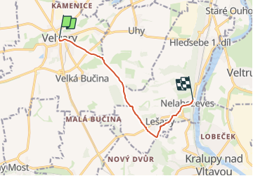
Percorso A piedi di 7,2 km da scoprire a Střední Čechy, Sconosciuto, Velvary. Questo percorso è proposto da SityTrail - itinéraires balisés pédestres.
Percorso creato da cz:KČT.
![Percorso A piedi Velvary - [Ž] Nelahozeves - Velvary - Photo 1](https://media.geolcdn.com/t/2048/auto/9daaf00e-c51d-43c1-870e-f1644d770afb.jpeg&format=jpg&maxdim=0 "Percorso A piedi Velvary - [Ž] Nelahozeves - Velvary - Photo 1")
![Percorso A piedi Velvary - [Ž] Nelahozeves - Velvary - Photo 2](https://media.geolcdn.com/t/2048/auto/9fd958f3-5b08-4813-8bab-05e0b1414def.jpeg&format=jpg&maxdim=0 "Percorso A piedi Velvary - [Ž] Nelahozeves - Velvary - Photo 2")
![Percorso A piedi Velvary - [Ž] Nelahozeves - Velvary - Photo 3](https://media.geolcdn.com/t/2048/auto/bd599629-b90b-4e2f-9540-ace9d62f7e09.jpeg&format=jpg&maxdim=0 "Percorso A piedi Velvary - [Ž] Nelahozeves - Velvary - Photo 3")
![Percorso A piedi Velvary - [Ž] Nelahozeves - Velvary - Photo 4](https://media.geolcdn.com/t/2048/auto/4b53fdd3-a9b3-4801-ba35-8d6affa65e15.jpeg&format=jpg&maxdim=0 "Percorso A piedi Velvary - [Ž] Nelahozeves - Velvary - Photo 4")
![Percorso A piedi Velvary - [Ž] Nelahozeves - Velvary - Photo 5](https://media.geolcdn.com/t/2048/auto/aeae6156-7834-462a-9dee-8cfcd4ab9d18.jpeg&format=jpg&maxdim=0 "Percorso A piedi Velvary - [Ž] Nelahozeves - Velvary - Photo 5")
![Percorso A piedi Velvary - [Ž] Nelahozeves - Velvary - Photo 6](https://media.geolcdn.com/t/2048/auto/7d4cda47-95c7-4639-b225-841cf566a4b0.jpeg&format=jpg&maxdim=0 "Percorso A piedi Velvary - [Ž] Nelahozeves - Velvary - Photo 6")
![Percorso A piedi Velvary - [Ž] Nelahozeves - Velvary - Photo 7](https://media.geolcdn.com/t/2048/auto/e2dcb334-0658-4815-aee1-0657f5158a45.jpeg&format=jpg&maxdim=0 "Percorso A piedi Velvary - [Ž] Nelahozeves - Velvary - Photo 7")
![Percorso A piedi Velvary - [Ž] Nelahozeves - Velvary - Photo 8](https://media.geolcdn.com/t/2048/auto/8fbf64e1-ea68-4a3b-b664-d2758625479b.jpeg&format=jpg&maxdim=0 "Percorso A piedi Velvary - [Ž] Nelahozeves - Velvary - Photo 8")
![Percorso A piedi Velvary - [Ž] Nelahozeves - Velvary - Photo 9](https://media.geolcdn.com/t/2048/auto/3dd487bf-3b30-48f2-8f97-8b0d27624dbd.jpeg&format=jpg&maxdim=0 "Percorso A piedi Velvary - [Ž] Nelahozeves - Velvary - Photo 9")
![Percorso A piedi Velvary - [Ž] Nelahozeves - Velvary - Photo 10](https://media.geolcdn.com/t/2048/auto/c0f289c8-19e4-4ee2-91c2-5f3e5d2c27f8.jpeg&format=jpg&maxdim=0 "Percorso A piedi Velvary - [Ž] Nelahozeves - Velvary - Photo 10")
![Percorso A piedi Kojetice - [Z] Kojetice - Kostelec nad Labem - Photo](https://media.geolcdn.com/t/375/260/b48711fe-946a-4219-93f6-8a21a39e13c4.jpeg&format=jpg&maxdim=2)
A piedi
A piedi
![Percorso A piedi - [Ž] Jenerálka - Nebušice - Photo](https://media.geolcdn.com/t/375/260/dac8635e-6312-4459-b501-cc0898393611.jpeg&format=jpg&maxdim=2)
A piedi
![Percorso A piedi Evaň - [Z] Poplze - Horka - Photo](https://media.geolcdn.com/t/375/260/58b6020a-01a4-4926-b083-ab4b33d6a3be.jpeg&format=jpg&maxdim=2)
A piedi
![Percorso A piedi Číčovice - [Ž] Malé Číčovice - Zákolany - Photo](https://media.geolcdn.com/t/375/260/27611625-39fc-4b9e-a6da-b31d609d094c.jpeg&format=jpg&maxdim=2)
A piedi
A piedi
A piedi
![Percorso A piedi Mělník - [Ž] Hořín - okružní trasa - Photo](https://media.geolcdn.com/t/375/260/32387249-b1a0-4843-aa71-31072a48ece3.jpeg&format=jpg&maxdim=2)
A piedi
![Percorso A piedi Mělník - [Ž] Mělník - Lhotka - Photo](https://media.geolcdn.com/t/375/260/6568a527-c601-419a-b951-03eae086182d.jpeg&format=jpg&maxdim=2)
A piedi