


4,1 km | 7,4 km-effort
![Percorso A piedi Štětí - [M] Štětí - Ledčice - Photo](https://media.geolcdn.com/t/1900/400/bec04fab-17ef-4ed8-9aa1-9f79da79c802.jpeg&format=pjpeg&maxdim=2)

Tous les sentiers balisés d’Europe GUIDE+


Applicazione GPS da escursionismo GRATUITA
 SityTrail
IGN / Istituti geografici
SityTrail World
Il mondo è tuo
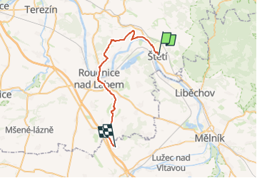
Percorso A piedi di 28 km da scoprire a Severozápad, Ústecký kraj, Štětí. Questo percorso è proposto da SityTrail - itinéraires balisés pédestres.
Percorso creato da cz:KČT.
![Percorso A piedi Štětí - [M] Štětí - Ledčice - Photo 1](https://media.geolcdn.com/t/2048/auto/ed27c355-96a1-4133-bbd1-e2deab0f15b8.jpeg&format=jpg&maxdim=0 "Percorso A piedi Štětí - [M] Štětí - Ledčice - Photo 1")
![Percorso A piedi Štětí - [M] Štětí - Ledčice - Photo 2](https://media.geolcdn.com/t/2048/auto/fe8aebbe-c99d-4049-bfe6-913b54ea5fee.jpeg&format=jpg&maxdim=0 "Percorso A piedi Štětí - [M] Štětí - Ledčice - Photo 2")
![Percorso A piedi Štětí - [M] Štětí - Ledčice - Photo 3](https://media.geolcdn.com/t/2048/auto/7d8bcbbe-dde3-4603-bc1d-8f7677cffbdf.jpeg&format=jpg&maxdim=0 "Percorso A piedi Štětí - [M] Štětí - Ledčice - Photo 3")
![Percorso A piedi Štětí - [M] Štětí - Ledčice - Photo 4](https://media.geolcdn.com/t/2048/auto/ded1e57c-672a-4d99-bac7-43154518c372.jpeg&format=jpg&maxdim=0 "Percorso A piedi Štětí - [M] Štětí - Ledčice - Photo 4")
![Percorso A piedi Štětí - [M] Štětí - Ledčice - Photo 5](https://media.geolcdn.com/t/2048/auto/1de0a485-22e2-4c69-9675-31f8ca6320bc.jpeg&format=jpg&maxdim=0 "Percorso A piedi Štětí - [M] Štětí - Ledčice - Photo 5")
![Percorso A piedi Štětí - [M] Štětí - Ledčice - Photo 6](https://media.geolcdn.com/t/2048/auto/b3e4912f-c404-4a6a-9ccd-66761535cd0c.jpeg&format=jpg&maxdim=0 "Percorso A piedi Štětí - [M] Štětí - Ledčice - Photo 6")
![Percorso A piedi Štětí - [M] Štětí - Ledčice - Photo 7](https://media.geolcdn.com/t/2048/auto/cdb43f0c-8273-4652-bd24-7be553bacc1c.jpeg&format=jpg&maxdim=0 "Percorso A piedi Štětí - [M] Štětí - Ledčice - Photo 7")
![Percorso A piedi Štětí - [M] Štětí - Ledčice - Photo 8](https://media.geolcdn.com/t/2048/auto/6b308111-598b-4afc-b0d0-9365bdec7693.jpeg&format=jpg&maxdim=0 "Percorso A piedi Štětí - [M] Štětí - Ledčice - Photo 8")
![Percorso A piedi Štětí - [M] Štětí - Ledčice - Photo 9](https://media.geolcdn.com/t/2048/auto/932f1760-17a5-4658-9967-583dff9c9f65.jpeg&format=jpg&maxdim=0 "Percorso A piedi Štětí - [M] Štětí - Ledčice - Photo 9")
![Percorso A piedi Štětí - [M] Štětí - Ledčice - Photo 10](https://media.geolcdn.com/t/2048/auto/bec04fab-17ef-4ed8-9aa1-9f79da79c802.jpeg&format=jpg&maxdim=0 "Percorso A piedi Štětí - [M] Štětí - Ledčice - Photo 10")
![Percorso A piedi Liběšice - [Ž] Liběšice - Sedlo (pod vrcholem) - Photo](https://media.geolcdn.com/t/375/260/e30fd15b-188b-44c1-93c2-4da6babe0937.jpeg&format=jpg&maxdim=2)
A piedi
A piedi
![Percorso A piedi Vysoká - [Ž] Harasov - Chloumek - Photo](https://media.geolcdn.com/t/375/260/bc275f67-78cb-4ea7-af7b-1cfdb0fea829.jpeg&format=jpg&maxdim=2)
A piedi
![Percorso A piedi Velvary - [Ž] Nelahozeves - Velvary - Photo](https://media.geolcdn.com/t/375/260/3dd487bf-3b30-48f2-8f97-8b0d27624dbd.jpeg&format=jpg&maxdim=2)
A piedi
A piedi
A piedi
![Percorso A piedi Mělník - [Z] Mělník - okružní trasa - Photo](https://media.geolcdn.com/t/375/260/e6c96ca9-333e-4cf1-8b0e-018ae508ba3d.jpeg&format=jpg&maxdim=2)
A piedi
![Percorso A piedi Želízy - [M] Kokořín - Zimořský důl - Photo](https://media.geolcdn.com/t/375/260/04ffd1a5-afe9-4e85-be18-0b7b38d70abe.jpeg&format=jpg&maxdim=2)
A piedi
![Percorso A piedi Litoměřice - [Z] Sebuzín - Litoměřice - Photo](https://media.geolcdn.com/t/375/260/d13b5b00-8ae2-4a20-b537-a715ffb460bd.jpeg&format=jpg&maxdim=2)
A piedi