![](/images/other/stat-length.png)
![Percorso A piedi The Municipal District of Wicklow - Saint Kevin's Way - Photo](https://media.geolcdn.com/t/1900/400/37007676-dd8b-47f4-a926-3cc7f09c0404.jpeg&format=pjpeg&maxdim=2)
Saint Kevin's Way
SityTrail - itinéraires balisés pédestres
Tous les sentiers balisés d’Europe GUIDE+
![Lunghezza](/images/other/stat-length.png)
Lunghezza
6,6 km
![Altitudine massima](https://static1.geolcdn.com/siteimages/upload/files/1508320355ic_sort_altitude_max_24dp.png)
Altitudine massima
477 m
![Dislivello positivo](https://static1.geolcdn.com/siteimages/upload/files/1508320355ic_sort_den_pos_24dp.png)
Dislivello positivo
355 m
![Km-Effort](/images/other/stat-length.png)
Km-Effort
10,2 km
![Altitudine minima](https://static1.geolcdn.com/siteimages/upload/files/1508320355ic_sort_altitude_min_24dp.png)
Altitudine minima
145 m
![Dislivello negativo](https://static1.geolcdn.com/siteimages/upload/files/1508320355ic_sort_den_neg_24dp.png)
Dislivello negativo
25 m
![Boucle](https://static1.geolcdn.com/siteimages/upload/files/16400158638029165_repeat_loop_refresh_sync_direction_icon.png)
Boucle
No
Tag
Data di creazione :
2025-02-06 12:02:50.355
Ultima modifica :
2025-02-06 12:02:50.355
![A piedi](https://static1.geolcdn.com/sitytour/trail-icons/100.png)
2h19
Difficoltà : Facile
![Scannerizza questo codice QR per aprire il percorso nell'applicazione SityTrail](https://capi.geolives.com/qq0zvz2zws4bq2lad0pu/sitytour/trails/4342776/qr.png?size=200)
Applicazione GPS da escursionismo GRATUITA
Chi siamo
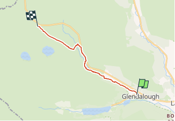
Percorso A piedi di 6,6 km da scoprire a Sconosciuto, County Wicklow, The Municipal District of Wicklow. Questo percorso è proposto da SityTrail - itinéraires balisés pédestres.
Descrizione
Simbolo: yellow monk on black ground
Localizzazione
Paese:
Ireland
Regione :
Sconosciuto
Dipartimento/Provincia :
County Wicklow
Comune :
The Municipal District of Wicklow
Località :
Brockagh
Partenza:(Dec)
Partenza:(UTM)
679184 ; 5876949 (29U) N.
Commenti
Percorsi nelle vicinanze
![Percorso A piedi The Municipal District of Wicklow - Spinc and Glenealo Valley - Photo](https://media.geolcdn.com/t/375/260/1560c5cb-814e-44b1-9214-44e578947b9a.jpeg&format=jpg&maxdim=2)
![A piedi A piedi](https://static1.geolcdn.com/sitytour/trail-icons/100.png)
Spinc and Glenealo Valley
A piedi
Facile
The Municipal District of Wicklow,
Sconosciuto,
County Wicklow,
Ireland
![](/images/other/stat-length.png)
9,2 km | 14,6 km-effort
3h 19min
![](https://static1.geolcdn.com/siteimages/upload/files/16400158638029165_repeat_loop_refresh_sync_direction_icon.png)
Sì
![Percorso Marcia The Municipal District of Wicklow - Glendalough - Photo](https://media.geolcdn.com/t/375/260/f9b26eb7-6032-4758-8e01-1b0a23e48b5d.jpg&format=jpg&maxdim=2)
![Marcia Marcia](https://static1.geolcdn.com/sitytour/trail-icons/101.png)
Glendalough
Marcia
Medio
The Municipal District of Wicklow,
Sconosciuto,
County Wicklow,
Ireland
![](/images/other/stat-length.png)
9,4 km | 13,7 km-effort
2h 21min
![](https://static1.geolcdn.com/siteimages/upload/files/16400158638029165_repeat_loop_refresh_sync_direction_icon.png)
Sì
![Percorso Marcia The Municipal District of Wicklow - Glendalough - Photo](https://media.geolcdn.com/t/375/260/ext.jpg?maxdim=2&url=https%3A%2F%2Fstatic1.geolcdn.com%2Fsiteimages%2Fupload%2Ffiles%2F1553511878bg_sport_marche.png)
![Marcia Marcia](https://static1.geolcdn.com/sitytour/trail-icons/101.png)
Glendalough
Marcia
Medio
The Municipal District of Wicklow,
Sconosciuto,
County Wicklow,
Ireland
![](/images/other/stat-length.png)
9,6 km | 14 km-effort
2h 59min
![](https://static1.geolcdn.com/siteimages/upload/files/16400158638029165_repeat_loop_refresh_sync_direction_icon.png)
Sì
![Percorso Marcia The Municipal District of Wicklow - Mountain Hike from Glendalough car park - Photo](https://media.geolcdn.com/t/375/260/ext.jpg?maxdim=2&url=https%3A%2F%2Fstatic1.geolcdn.com%2Fsiteimages%2Fupload%2Ffiles%2F1553511878bg_sport_marche.png)
![Marcia Marcia](https://static1.geolcdn.com/sitytour/trail-icons/101.png)
Mountain Hike from Glendalough car park
Marcia
Molto facile
The Municipal District of Wicklow,
Sconosciuto,
County Wicklow,
Ireland
![](/images/other/stat-length.png)
17,2 km | 26 km-effort
6h 1min
![](https://static1.geolcdn.com/siteimages/upload/files/16400158638029165_repeat_loop_refresh_sync_direction_icon.png)
Sì
![Percorso Marcia The Municipal District of Wicklow - The Brockaghs and St Kevins Road - Photo](https://media.geolcdn.com/t/375/260/ext.jpg?maxdim=2&url=https%3A%2F%2Fstatic1.geolcdn.com%2Fsiteimages%2Fupload%2Ffiles%2F1553511878bg_sport_marche.png)
![Marcia Marcia](https://static1.geolcdn.com/sitytour/trail-icons/101.png)
The Brockaghs and St Kevins Road
Marcia
Molto facile
The Municipal District of Wicklow,
Sconosciuto,
County Wicklow,
Ireland
![](/images/other/stat-length.png)
16,7 km | 25 km-effort
Sconosciuto
![](https://static1.geolcdn.com/siteimages/upload/files/16400158638029165_repeat_loop_refresh_sync_direction_icon.png)
Sì
![Percorso Marcia The Municipal District of Wicklow - glendalough outer circuit - Photo](https://media.geolcdn.com/t/375/260/ext.jpg?maxdim=2&url=https%3A%2F%2Fstatic1.geolcdn.com%2Fsiteimages%2Fupload%2Ffiles%2F1553511878bg_sport_marche.png)
![Marcia Marcia](https://static1.geolcdn.com/sitytour/trail-icons/101.png)
glendalough outer circuit
Marcia
Molto facile
The Municipal District of Wicklow,
Sconosciuto,
County Wicklow,
Ireland
![](/images/other/stat-length.png)
21 km | 33 km-effort
Sconosciuto
![](https://static1.geolcdn.com/siteimages/upload/files/16400158638029165_repeat_loop_refresh_sync_direction_icon.png)
Sì
![Percorso Altra attività The Municipal District of Wicklow - Camaderry - Photo](https://media.geolcdn.com/t/375/260/ext.jpg?maxdim=2&url=https%3A%2F%2Fstatic1.geolcdn.com%2Fsiteimages%2Fupload%2Ffiles%2F1545311037marcheuse_200dpi.jpg)
![Altra attività Altra attività](https://static1.geolcdn.com/sitytour/trail-icons/900.png)
Camaderry
Altra attività
Molto facile
The Municipal District of Wicklow,
Sconosciuto,
County Wicklow,
Ireland
![](/images/other/stat-length.png)
8,8 km | 15,8 km-effort
Sconosciuto
![](https://static1.geolcdn.com/siteimages/upload/files/16400158638029165_repeat_loop_refresh_sync_direction_icon.png)
Sì
![Percorso Altra attività The Municipal District of Wicklow - Camaderry - Photo](https://media.geolcdn.com/t/375/260/ext.jpg?maxdim=2&url=https%3A%2F%2Fstatic1.geolcdn.com%2Fsiteimages%2Fupload%2Ffiles%2F1545311037marcheuse_200dpi.jpg)
![Altra attività Altra attività](https://static1.geolcdn.com/sitytour/trail-icons/900.png)
Camaderry
Altra attività
Molto facile
The Municipal District of Wicklow,
Sconosciuto,
County Wicklow,
Ireland
![](/images/other/stat-length.png)
12,6 km | 20 km-effort
Sconosciuto
![](https://static1.geolcdn.com/siteimages/upload/files/16400158638029165_repeat_loop_refresh_sync_direction_icon.png)
Sì
![Percorso Marcia The Municipal District of Wicklow - glendalough - Photo](https://media.geolcdn.com/t/375/260/ext.jpg?maxdim=2&url=https%3A%2F%2Fstatic1.geolcdn.com%2Fsiteimages%2Fupload%2Ffiles%2F1553511878bg_sport_marche.png)
![Marcia Marcia](https://static1.geolcdn.com/sitytour/trail-icons/101.png)
glendalough
Marcia
Medio
The Municipal District of Wicklow,
Sconosciuto,
County Wicklow,
Ireland
![](/images/other/stat-length.png)
5,6 km | 7,3 km-effort
1h 39min
![](https://static1.geolcdn.com/siteimages/upload/files/16400158638029165_repeat_loop_refresh_sync_direction_icon.png)
Sì