![](/images/other/stat-length.png)
![Percorso A piedi Unknown - The Dramway - Photo](https://media.geolcdn.com/t/1900/400/ext.pjpeg?maxdim=2&url=https%3A%2F%2Fstatic1.geolcdn.com%2Fsiteimages%2Fupload%2Ffiles%2F1545311037marcheuse_200dpi.jpg)
The Dramway
SityTrail - itinéraires balisés pédestres
Tous les sentiers balisés d’Europe GUIDE+
![Lunghezza](/images/other/stat-length.png)
Lunghezza
14,9 km
![Altitudine massima](https://static1.geolcdn.com/siteimages/upload/files/1508320355ic_sort_altitude_max_24dp.png)
Altitudine massima
85 m
![Dislivello positivo](https://static1.geolcdn.com/siteimages/upload/files/1508320355ic_sort_den_pos_24dp.png)
Dislivello positivo
146 m
![Km-Effort](/images/other/stat-length.png)
Km-Effort
16,7 km
![Altitudine minima](https://static1.geolcdn.com/siteimages/upload/files/1508320355ic_sort_altitude_min_24dp.png)
Altitudine minima
10 m
![Dislivello negativo](https://static1.geolcdn.com/siteimages/upload/files/1508320355ic_sort_den_neg_24dp.png)
Dislivello negativo
87 m
![Boucle](https://static1.geolcdn.com/siteimages/upload/files/16400158638029165_repeat_loop_refresh_sync_direction_icon.png)
Boucle
No
Tag
Data di creazione :
2025-02-04 10:52:50.934
Ultima modifica :
2025-02-05 08:12:47.397
![A piedi](https://static1.geolcdn.com/sitytour/trail-icons/100.png)
3h47
Difficoltà : Facile
![Scannerizza questo codice QR per aprire il percorso nell'applicazione SityTrail](https://capi.geolives.com/qq0zvz2zws4bq2lad0pu/sitytour/trails/4339921/qr.png?size=200)
Applicazione GPS da escursionismo GRATUITA
Chi siamo
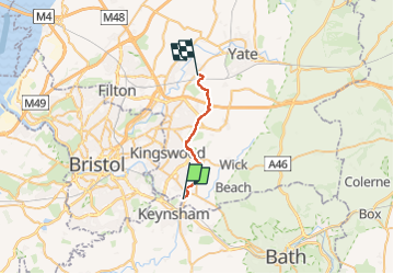
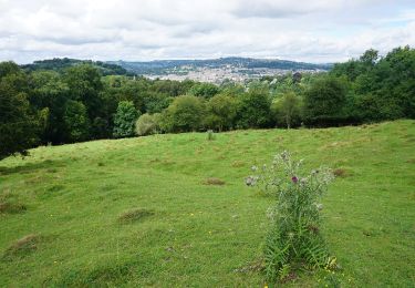
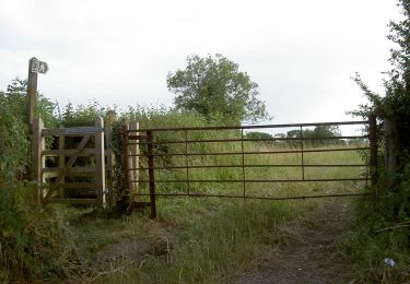
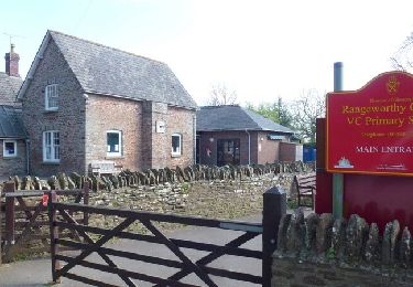
Percorso A piedi di 14,9 km da scoprire a Inghilterra, South Gloucestershire. Questo percorso è proposto da SityTrail - itinéraires balisés pédestres.
Descrizione
Simbolo: Green signs with logo
Localizzazione
Paese:
United Kingdom
Regione :
Inghilterra
Dipartimento/Provincia :
South Gloucestershire
Comune :
Unknown
Località :
Unknown
Partenza:(Dec)
Partenza:(UTM)
535587 ; 5697380 (30U) N.
Commenti
Percorsi nelle vicinanze
![Percorso A piedi - Prior's Wood - Photo](https://media.geolcdn.com/t/375/260/acbc1bce-18f0-457f-af5c-dfef7bc38652.jpeg&format=jpg&maxdim=2)
![A piedi A piedi](https://static1.geolcdn.com/sitytour/trail-icons/100.png)
Prior's Wood
A piedi
Facile
,
Inghilterra,
North Somerset,
United Kingdom
![](/images/other/stat-length.png)
3,1 km | 4,3 km-effort
58min
![](https://static1.geolcdn.com/siteimages/upload/files/16400158638029165_repeat_loop_refresh_sync_direction_icon.png)
Sì
![Percorso A piedi - Bath Skyline - Photo](https://media.geolcdn.com/t/375/260/f1af91b8-6763-482f-996c-c637d22deac6.jpeg&format=jpg&maxdim=2)
![A piedi A piedi](https://static1.geolcdn.com/sitytour/trail-icons/100.png)
Bath Skyline
A piedi
Facile
,
Inghilterra,
Bath and North East Somerset,
United Kingdom
![](/images/other/stat-length.png)
9,3 km | 12 km-effort
2h 43min
![](https://static1.geolcdn.com/siteimages/upload/files/16400158638029165_repeat_loop_refresh_sync_direction_icon.png)
Sì
![Percorso A piedi - Three Peaks Walk - Photo](https://media.geolcdn.com/t/375/260/8306e84a-44f7-4272-b2d9-e5792bb8d3bb.jpeg&format=jpg&maxdim=2)
![A piedi A piedi](https://static1.geolcdn.com/sitytour/trail-icons/100.png)
Three Peaks Walk
A piedi
Difficile
,
Inghilterra,
Bath and North East Somerset,
United Kingdom
![](/images/other/stat-length.png)
27 km | 34 km-effort
7h 45min
![](https://static1.geolcdn.com/siteimages/upload/files/16400158638029165_repeat_loop_refresh_sync_direction_icon.png)
Sì
![Percorso A piedi - Jubilee Way (Gloucestershire) - Photo](https://media.geolcdn.com/t/375/260/352e743c-46e4-4c8d-ae78-49084edf7625.jpeg&format=jpg&maxdim=2)
![A piedi A piedi](https://static1.geolcdn.com/sitytour/trail-icons/100.png)
Jubilee Way (Gloucestershire)
A piedi
Facile
,
Inghilterra,
South Gloucestershire,
United Kingdom
![](/images/other/stat-length.png)
4,3 km | 4,7 km-effort
1h 3min
![](https://static1.geolcdn.com/siteimages/upload/files/16400158638029165_repeat_loop_refresh_sync_direction_icon.png)
No
![Percorso Marcia - un petit tour dans Bristol - Photo](https://media.geolcdn.com/t/375/260/ext.jpg?maxdim=2&url=https%3A%2F%2Fservices.sitytrail.com%2FGeolivesWS%2FDownloadMedia.ashx%3FTrailID%3D430039%26Media%3Dfix__20150605194236.jpg)
![Marcia Marcia](https://static1.geolcdn.com/sitytour/trail-icons/101.png)
un petit tour dans Bristol
Marcia
Molto difficile
,
Inghilterra,
City of Bristol,
United Kingdom
![](/images/other/stat-length.png)
8,2 km | 9,9 km-effort
2h 9min
![](https://static1.geolcdn.com/siteimages/upload/files/16400158638029165_repeat_loop_refresh_sync_direction_icon.png)
Sì
![Percorso Marcia - j9 Bath - Photo](https://media.geolcdn.com/t/375/260/ext.jpg?maxdim=2&url=https%3A%2F%2Fstatic1.geolcdn.com%2Fsiteimages%2Fupload%2Ffiles%2F1553511878bg_sport_marche.png)
![Marcia Marcia](https://static1.geolcdn.com/sitytour/trail-icons/101.png)
j9 Bath
Marcia
Difficile
,
Inghilterra,
Bath and North East Somerset,
United Kingdom
![](/images/other/stat-length.png)
12,5 km | 14,6 km-effort
3h 1min
![](https://static1.geolcdn.com/siteimages/upload/files/16400158638029165_repeat_loop_refresh_sync_direction_icon.png)
No
![Percorso Marcia - j8 Bradford on avon - Photo](https://media.geolcdn.com/t/375/260/ext.jpg?maxdim=2&url=https%3A%2F%2Fstatic1.geolcdn.com%2Fsiteimages%2Fupload%2Ffiles%2F1553511878bg_sport_marche.png)
![Marcia Marcia](https://static1.geolcdn.com/sitytour/trail-icons/101.png)
j8 Bradford on avon
Marcia
Medio
,
Inghilterra,
Bath and North East Somerset,
United Kingdom
![](/images/other/stat-length.png)
9,9 km | 11,4 km-effort
2h 35min
![](https://static1.geolcdn.com/siteimages/upload/files/16400158638029165_repeat_loop_refresh_sync_direction_icon.png)
No
![Percorso Marcia - j7 Bath Skyline, vergers, cimetière - Photo](https://media.geolcdn.com/t/375/260/ext.jpg?maxdim=2&url=https%3A%2F%2Fstatic1.geolcdn.com%2Fsiteimages%2Fupload%2Ffiles%2F1553511878bg_sport_marche.png)
![Marcia Marcia](https://static1.geolcdn.com/sitytour/trail-icons/101.png)
j7 Bath Skyline, vergers, cimetière
Marcia
Difficile
,
Inghilterra,
Bath and North East Somerset,
United Kingdom
![](/images/other/stat-length.png)
10,7 km | 14,1 km-effort
3h 11min
![](https://static1.geolcdn.com/siteimages/upload/files/16400158638029165_repeat_loop_refresh_sync_direction_icon.png)
Sì