![](/images/other/stat-length.png)
![Percorso Marcia West Cork - Hungry Hill - Photo](https://media.geolcdn.com/t/1900/400/d0b58611-9340-4ec7-9d97-0e843f5725a3.jpg&format=pjpeg&maxdim=2)
Hungry Hill
Geert H.
Utente
![Lunghezza](/images/other/stat-length.png)
Lunghezza
12,3 km
![Altitudine massima](https://static1.geolcdn.com/siteimages/upload/files/1508320355ic_sort_altitude_max_24dp.png)
Altitudine massima
679 m
![Dislivello positivo](https://static1.geolcdn.com/siteimages/upload/files/1508320355ic_sort_den_pos_24dp.png)
Dislivello positivo
624 m
![Km-Effort](/images/other/stat-length.png)
Km-Effort
21 km
![Altitudine minima](https://static1.geolcdn.com/siteimages/upload/files/1508320355ic_sort_altitude_min_24dp.png)
Altitudine minima
31 m
![Dislivello negativo](https://static1.geolcdn.com/siteimages/upload/files/1508320355ic_sort_den_neg_24dp.png)
Dislivello negativo
693 m
![Boucle](https://static1.geolcdn.com/siteimages/upload/files/16400158638029165_repeat_loop_refresh_sync_direction_icon.png)
Boucle
No
Data di creazione :
2024-08-17 08:52:57.032
Ultima modifica :
2024-08-23 10:07:06.85
![Marcia](https://static1.geolcdn.com/sitytour/trail-icons/101.png)
3h51
Difficoltà : Difficile
![Scannerizza questo codice QR per aprire il percorso nell'applicazione SityTrail](https://capi.geolives.com/qq0zvz2zws4bq2lad0pu/sitytour/trails/4158710/qr.png?size=200)
Applicazione GPS da escursionismo GRATUITA
Chi siamo
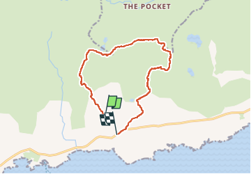
Percorso Marcia di 12,3 km da scoprire a Sconosciuto, County Cork, West Cork. Questo percorso è proposto da Geert H..
Descrizione
Beware, this trail is impossible to follow when the visibility is poor. The markings uphill to the top are barely visible red paint markers or stone cairns. The path from the top downhill is not marked and was followed by following the "path" on the openstreet map and GPS. But it is adventurous to say at least.
Localizzazione
Paese:
Ireland
Regione :
Sconosciuto
Dipartimento/Provincia :
County Cork
Comune :
West Cork
Località :
Curryglass
Partenza:(Dec)
Partenza:(UTM)
442962 ; 5724521 (29U) N.
Commenti
Percorsi nelle vicinanze
![Percorso Marcia West Cork - All Rerrin Loop - Photo](https://media.geolcdn.com/t/375/260/ext.jpg?maxdim=2&url=https%3A%2F%2Fstatic1.geolcdn.com%2Fsiteimages%2Fupload%2Ffiles%2F1553511878bg_sport_marche.png)
![Marcia Marcia](https://static1.geolcdn.com/sitytour/trail-icons/101.png)
All Rerrin Loop
Marcia
Facile
West Cork,
Sconosciuto,
County Cork,
Ireland
![](/images/other/stat-length.png)
6,4 km | 7,8 km-effort
Sconosciuto
![](https://static1.geolcdn.com/siteimages/upload/files/16400158638029165_repeat_loop_refresh_sync_direction_icon.png)
Sì