Percorso A piedi Maasmechelen - Etappe 3: Terhills (Maasmechelen) – Duinengordel (Opoeteren): 23 km - Photo

Etappe 3: Terhills (Maasmechelen) – Duinengordel (Opoeteren): 23 km

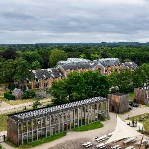
The Hoge Kempen National Park

© OpenStreetMap contributors
Lunghezza
Lunghezza
24 km
Altitudine massima
Altitudine massima
113 m
Dislivello positivo
Dislivello positivo
402 m
Km-Effort
Km-Effort  
29 km
Altitudine minima
Altitudine minima
34 m
Dislivello negativo
Dislivello negativo
392 m
Boucle
Boucle
No
Data di creazione :
2023-03-20 13:57:31.606
Ultima modifica :
2023-03-20 13:59:46.46

(0 Recensione)

A piedi
A piedi
6h37
Difficoltà : Medio

Scannerizza questo codice QR per aprire il percorso nell'applicazione SityTrail

Applicazione GPS da escursionismo GRATUITA

Logo SityTrail SityTrail

IGN / Istituti geografici

Scarica SityTrail dall'App Store Scarica SityTrail da Google Play

Logo SityTrail SityTrail World

Il mondo è tuo

Scarica SityTrail dall'App Store Scarica SityTrail da Google Play Scarica SityTrail da Huawei AppGallery

Chi siamo

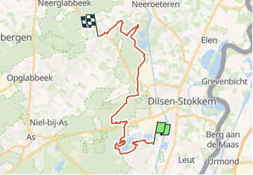
Percorso A piedi di 24 km da scoprire a Vlaanderen, Limburg, Maasmechelen. Questo percorso è proposto da National Park Trail.

Descrizione

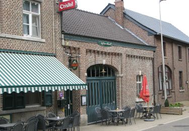
Just like the previous stage, this one runs from south to north across the edge of the Kempen Plateau. Here coniferous forests prevail over heathland. The hike starts with a literal and figurative highlight: climbing the slag heaps of the former Eisden coal mine. Further north you get to know Bergerven, where gravel extraction created a waterfowl area. Finally, you will discover the Bosbeek valley, ending up in the village of Opoeteren.

Profilo altimetrico

Foto

Localizzazione

Paese:
Belgium
Regione :
Vlaanderen
Dipartimento/Provincia :
Limburg
Comune :
Maasmechelen
Località :
Eisden
Partenza:(Dec)
Partenza:(UTM)
689691 ; 5653470 (31U) N.

Percorsi nelle vicinanze

Percorso Marcia Maasmechelen - Mechelse Heide  - Photo
Marcia
GUIDE
mumu.larandonneuse

Marcia

Facile
(2)
Maasmechelen, Vlaanderen, Limburg, Belgium
14,2 km | 16,2 km-effort
3h 41min
Sì
Percorso A piedi Maasmechelen - Erfgoedwandeling Eisden Tuinwijk - Photo
A piedi
PRO

A piedi

Facile
Maasmechelen, Vlaanderen, Limburg, Belgium
3,1 km | 3,3 km-effort
44min
Sì
Percorso A piedi Dilsen-Stokkem - Connecterra Rode driehoek - Photo
A piedi
PRO

A piedi

Facile
Dilsen-Stokkem, Vlaanderen, Limburg, Belgium
6,2 km | 7 km-effort
1h 35min
No
Percorso A piedi Dilsen-Stokkem - Stokkem & Oud-Dilsen Blauwe ruit - Photo
A piedi
PRO

A piedi

Facile
Dilsen-Stokkem, Vlaanderen, Limburg, Belgium
4,7 km | 5 km-effort
1h 8min
Sì
Percorso A piedi Maaseik - Bergerven Blauwe ruit - Photo
A piedi
PRO

A piedi

Facile
Maaseik, Vlaanderen, Limburg, Belgium
7,4 km | 8,3 km-effort
1h 53min
Sì
Percorso A piedi Maasmechelen - Leut & Meeswijk Oranje bol - Photo
A piedi
PRO

A piedi

Facile
Maasmechelen, Vlaanderen, Limburg, Belgium
10,3 km | 11,2 km-effort
2h 33min
Sì
Percorso A piedi Maasmechelen - Leut & Meeswijk Rode driehoek - Photo
A piedi
PRO

A piedi

Facile
Maasmechelen, Vlaanderen, Limburg, Belgium
14 km | 15 km-effort
3h 24min
Sì
Percorso A piedi Maasmechelen - Leut & Meeswijk Gele zeshoek - Photo
A piedi
PRO

A piedi

Facile
Maasmechelen, Vlaanderen, Limburg, Belgium
7 km | 7,4 km-effort
1h 40min
Sì
Percorso A piedi Maasmechelen - Leut & Meeswijk Groene rechthoek - Photo
A piedi
PRO

A piedi

Facile
Maasmechelen, Vlaanderen, Limburg, Belgium
3,5 km | 3,9 km-effort
53min
Sì


Chiudi
I miei abbonamenti