Grand grande 17km SityTrail > Percorsi > Outdoor > France > Grande Est > Vosges > Grand SityTrail > Percorsi > Outdoor > France > Grande Est > Vosges > Grand Grand grande 17km Nila81 Utente 3D © OpenStreetMap contributors Lunghezza 16,8 km Altitudine massima 440 m Dislivello positivo 236 m Km-Effort 19,9 km Altitudine minima 335 m Dislivello negativo 235 m Boucle Sì Data di creazione : 2023-02-17 20:05:57.343 Ultima modifica : 2023-02-22 13:13:47.508 (0 Recensione) Marcia 4h31 Difficoltà : Molto difficile Applicazione GPS da escursionismo GRATUITA SityTrail IGN / Istituti geografici SityTrail World Il mondo è tuo Chi siamo 
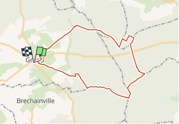
Percorso Marcia di 16,8 km da scoprire a Grande Est, Vosges, Grand. Questo percorso è proposto da Nila81. Legende | Maggiori dettagli (PDF) Profilo altimetrico Legende > 15% 15% - 10% 10% - 5% di piatto 5% - 10% 10% - 15% 15% - 30% > 30% Localizzazione Paese: France Regione : Grande Est Dipartimento/Provincia : Vosges Comune : Grand Località : Unknown Partenza:(Dec) 48.38470116560938 / 5.486512184143067 Partenza:(UTM) 684093 ; 5362047 (31U) N. Commenti Accedi per lasciare un commento o una valutazione Percorsi nelle vicinanze tracegps Un village à remonter le temps... - Grand Marcia Facile Grand, Grande Est, Vosges, France 2,9 km | 3,2 km-effort 1h 0min Sì Nila81 Grand G 2 Marcia Difficile Grand, Grande Est, Vosges, France 10,8 km | 13,1 km-effort 2h 58min Sì Nila81 Grand G 1 Marcia Medio Grand, Grande Est, Vosges, France 6,4 km | 7,6 km-effort 1h 44min Sì Nila81 Grand G 3 Marcia Difficile Grand, Grande Est, Vosges, France 13,9 km | 16,7 km-effort 3h 48min Sì