![](/images/other/stat-length.png)
![Percorso Marcia Chantemerle-lès-Grignan - SityTrail - Clansayes Le Rouvergue 12km - Photo](https://media.geolcdn.com/t/1900/400/ext.pjpeg?maxdim=2&url=https%3A%2F%2Fstatic1.geolcdn.com%2Fsiteimages%2Fupload%2Ffiles%2F1553511878bg_sport_marche.png)
SityTrail - Clansayes Le Rouvergue 12km
thonyc
Utente GUIDE
![Lunghezza](/images/other/stat-length.png)
Lunghezza
13,8 km
![Altitudine massima](https://static1.geolcdn.com/siteimages/upload/files/1508320355ic_sort_altitude_max_24dp.png)
Altitudine massima
324 m
![Dislivello positivo](https://static1.geolcdn.com/siteimages/upload/files/1508320355ic_sort_den_pos_24dp.png)
Dislivello positivo
332 m
![Km-Effort](/images/other/stat-length.png)
Km-Effort
18,2 km
![Altitudine minima](https://static1.geolcdn.com/siteimages/upload/files/1508320355ic_sort_altitude_min_24dp.png)
Altitudine minima
139 m
![Dislivello negativo](https://static1.geolcdn.com/siteimages/upload/files/1508320355ic_sort_den_neg_24dp.png)
Dislivello negativo
329 m
![Boucle](https://static1.geolcdn.com/siteimages/upload/files/16400158638029165_repeat_loop_refresh_sync_direction_icon.png)
Boucle
Sì
Data di creazione :
2022-10-03 13:15:40.347
Ultima modifica :
2022-11-24 14:59:41.664
![Marcia](https://static1.geolcdn.com/sitytour/trail-icons/101.png)
4h00
Difficoltà : Medio
![Scannerizza questo codice QR per aprire il percorso nell'applicazione SityTrail](https://capi.geolives.com/qq0zvz2zws4bq2lad0pu/sitytour/trails/3411473/qr.png?size=200)
Applicazione GPS da escursionismo GRATUITA
Chi siamo
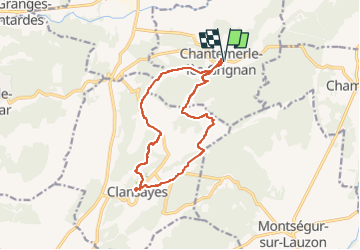
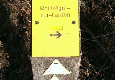
Percorso Marcia di 13,8 km da scoprire a Auvergne-Rhône-Alpes, Drôme, Chantemerle-lès-Grignan. Questo percorso è proposto da thonyc.
Descrizione
Très jolie rando.
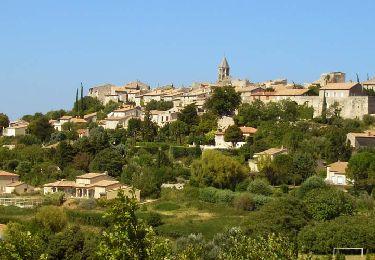
Village très bien restauré.
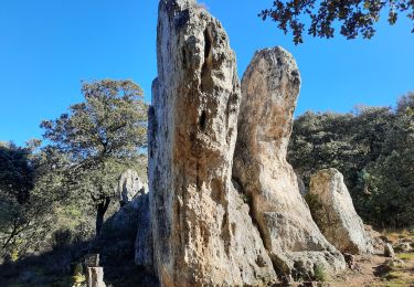
Les Jumelles de Rozet.
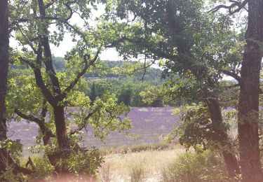
Le plateau du Rouvergue et ses champs de lavandes.
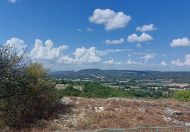
De belles vues sur la vallée du Rhône.
Localizzazione
Paese:
France
Regione :
Auvergne-Rhône-Alpes
Dipartimento/Provincia :
Drôme
Comune :
Chantemerle-lès-Grignan
Località :
Unknown
Partenza:(Dec)
Partenza:(UTM)
646280 ; 4918283 (31T) N.
Commenti
Percorsi nelle vicinanze
![Percorso Marcia Clansayes - SityTrail - Clansayes Le Rouvergue 6km - Photo](https://media.geolcdn.com/t/375/260/ext.jpg?maxdim=2&url=https%3A%2F%2Fmedia.geolcdn.com%2Ff%2Fde3feb6f-5587-4e87-a580-1261cf3df48e.jpg)
![Marcia Marcia](https://static1.geolcdn.com/sitytour/trail-icons/101.png)
SityTrail - Clansayes Le Rouvergue 6km
Marcia
Facile
(2)
Clansayes,
Auvergne-Rhône-Alpes,
Drôme,
France
![](/images/other/stat-length.png)
7,2 km | 8,4 km-effort
2h 0min
![](https://static1.geolcdn.com/siteimages/upload/files/16400158638029165_repeat_loop_refresh_sync_direction_icon.png)
Sì
![Percorso Marcia Chantemerle-lès-Grignan - Chantemerle-Les Grignan Les jumelles du Rozet Clansayes 15km - Photo](https://media.geolcdn.com/t/375/260/ext.jpg?maxdim=2&url=https%3A%2F%2Fmedia.geolcdn.com%2Ff%2Fe778a7ff-aae4-45e1-a529-5e7212fd1471.jpg)
![Marcia Marcia](https://static1.geolcdn.com/sitytour/trail-icons/101.png)
Chantemerle-Les Grignan Les jumelles du Rozet Clansayes 15km
Marcia
Molto difficile
(3)
Chantemerle-lès-Grignan,
Auvergne-Rhône-Alpes,
Drôme,
France
![](/images/other/stat-length.png)
15 km | 19,7 km-effort
4h 28min
![](https://static1.geolcdn.com/siteimages/upload/files/16400158638029165_repeat_loop_refresh_sync_direction_icon.png)
Sì
![Percorso Marcia Roussas - Roussas Panassas 8 km - Photo](https://media.geolcdn.com/t/375/260/ext.jpg?maxdim=2&url=https%3A%2F%2Fmedia.geolcdn.com%2Ff%2Fdaa93b3b-e486-4ddd-9c21-8f099d0a496e.jpg)
![Marcia Marcia](https://static1.geolcdn.com/sitytour/trail-icons/101.png)
Roussas Panassas 8 km
Marcia
Facile
(1)
Roussas,
Auvergne-Rhône-Alpes,
Drôme,
France
![](/images/other/stat-length.png)
7,8 km | 10,6 km-effort
2h 31min
![](https://static1.geolcdn.com/siteimages/upload/files/16400158638029165_repeat_loop_refresh_sync_direction_icon.png)
Sì
![Percorso Marcia Montségur-sur-Lauzon - Bassin des druides. Montségur-lauzon - Photo](https://media.geolcdn.com/t/375/260/ext.jpg?maxdim=2&url=https%3A%2F%2Fservices.sitytrail.com%2FGeolivesWS%2FDownloadMedia.ashx%3FTrailID%3D892897%26Media%3Dfix__20180124152347.jpg)
![Marcia Marcia](https://static1.geolcdn.com/sitytour/trail-icons/101.png)
Bassin des druides. Montségur-lauzon
Marcia
Facile
(1)
Montségur-sur-Lauzon,
Auvergne-Rhône-Alpes,
Drôme,
France
![](/images/other/stat-length.png)
10,7 km | 13,1 km-effort
3h 14min
![](https://static1.geolcdn.com/siteimages/upload/files/16400158638029165_repeat_loop_refresh_sync_direction_icon.png)
Sì
![Percorso Marcia Chantemerle-lès-Grignan - Crevasses de Chantemerle - Photo](https://media.geolcdn.com/t/375/260/ext.jpg?maxdim=2&url=https%3A%2F%2Fstatic1.geolcdn.com%2Fsiteimages%2Fupload%2Ffiles%2F1553511878bg_sport_marche.png)
![Marcia Marcia](https://static1.geolcdn.com/sitytour/trail-icons/101.png)
Crevasses de Chantemerle
Marcia
Medio
(1)
Chantemerle-lès-Grignan,
Auvergne-Rhône-Alpes,
Drôme,
France
![](/images/other/stat-length.png)
6,9 km | 9 km-effort
2h 2min
![](https://static1.geolcdn.com/siteimages/upload/files/16400158638029165_repeat_loop_refresh_sync_direction_icon.png)
Sì
![Percorso Marcia Clansayes - SityTrail - 2656269 - chantemerle-clansayes-15km - Photo](https://media.geolcdn.com/t/375/260/ext.jpg?maxdim=2&url=https%3A%2F%2Fmedia.geolcdn.com%2Ff%2F10944c4f-f60a-41d6-ab1f-e2a3431a6612.jpg)
![Marcia Marcia](https://static1.geolcdn.com/sitytour/trail-icons/101.png)
SityTrail - 2656269 - chantemerle-clansayes-15km
Marcia
Facile
Clansayes,
Auvergne-Rhône-Alpes,
Drôme,
France
![](/images/other/stat-length.png)
12,4 km | 15,8 km-effort
3h 0min
![](https://static1.geolcdn.com/siteimages/upload/files/16400158638029165_repeat_loop_refresh_sync_direction_icon.png)
Sì
![Percorso Marcia Chantemerle-lès-Grignan - Chantemerle Les crevasses 8km - Photo](https://media.geolcdn.com/t/375/260/ext.jpg?maxdim=2&url=https%3A%2F%2Fmedia.geolcdn.com%2Ff%2F431d5085-52aa-456d-90d6-4dc31ac6daad.jpg)
![Marcia Marcia](https://static1.geolcdn.com/sitytour/trail-icons/101.png)
Chantemerle Les crevasses 8km
Marcia
Medio
Chantemerle-lès-Grignan,
Auvergne-Rhône-Alpes,
Drôme,
France
![](/images/other/stat-length.png)
7,6 km | 9,8 km-effort
2h 4min
![](https://static1.geolcdn.com/siteimages/upload/files/16400158638029165_repeat_loop_refresh_sync_direction_icon.png)
Sì
![Percorso Marcia Valaurie - Valaurie Aiguebelle 16km - Photo](https://media.geolcdn.com/t/375/260/ext.jpg?maxdim=2&url=https%3A%2F%2Fmedia.geolcdn.com%2Ff%2Fdd559e93-ad87-4ef8-876d-977a34ec8b7a.jpg)
![Marcia Marcia](https://static1.geolcdn.com/sitytour/trail-icons/101.png)
Valaurie Aiguebelle 16km
Marcia
Medio
Valaurie,
Auvergne-Rhône-Alpes,
Drôme,
France
![](/images/other/stat-length.png)
16 km | 21 km-effort
5h 0min
![](https://static1.geolcdn.com/siteimages/upload/files/16400158638029165_repeat_loop_refresh_sync_direction_icon.png)
Sì
![Percorso Marcia Clansayes - clansayes - Photo](https://media.geolcdn.com/t/375/260/ext.jpg?maxdim=2&url=https%3A%2F%2Fmedia.geolcdn.com%2Ff%2Fe1927e02-68cb-404c-8cfe-a99af4c885ec.jpg)
![Marcia Marcia](https://static1.geolcdn.com/sitytour/trail-icons/101.png)
clansayes
Marcia
Medio
(1)
Clansayes,
Auvergne-Rhône-Alpes,
Drôme,
France
![](/images/other/stat-length.png)
9,7 km | 14 km-effort
4h 49min
![](https://static1.geolcdn.com/siteimages/upload/files/16400158638029165_repeat_loop_refresh_sync_direction_icon.png)
Sì