![](/images/other/stat-length.png)
Saint-Hubert - La Borne (SH07)
La Grande Forêt de Saint-Hubert
Randonnées de la Grande Forêt de Saint-Hubert GUIDE+
![Lunghezza](/images/other/stat-length.png)
![Altitudine massima](https://static1.geolcdn.com/siteimages/upload/files/1508320355ic_sort_altitude_max_24dp.png)
![Dislivello positivo](https://static1.geolcdn.com/siteimages/upload/files/1508320355ic_sort_den_pos_24dp.png)
![Km-Effort](/images/other/stat-length.png)
![Altitudine minima](https://static1.geolcdn.com/siteimages/upload/files/1508320355ic_sort_altitude_min_24dp.png)
![Dislivello negativo](https://static1.geolcdn.com/siteimages/upload/files/1508320355ic_sort_den_neg_24dp.png)
![Boucle](https://static1.geolcdn.com/siteimages/upload/files/16400158638029165_repeat_loop_refresh_sync_direction_icon.png)
![Tag](https://services.sitytrail.com/GeolivesWS/DownloadMedia.ashx?TrailID=334588&Media=balise.png)
![Marcia](https://static1.geolcdn.com/sitytour/trail-icons/101.png)
3h47
Difficoltà : Difficile
![Scannerizza questo codice QR per aprire il percorso nell'applicazione SityTrail](https://capi.geolives.com/qq0zvz2zws4bq2lad0pu/sitytour/trails/334588/qr.png?size=200)
Applicazione GPS da escursionismo GRATUITA
Chi siamo
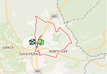
Percorso Marcia di 13,9 km da scoprire a Wallonie, Luxembourg, Saint-Hubert. Questo percorso è proposto da La Grande Forêt de Saint-Hubert.
Descrizione
Extrait de la carte de promenade « Au Pays de Saint-Hubert » (30 balades pédestres, 6 circuits VTT – carte topographique 1/25.000) disponible au Royal Syndicat d’Initiative de Saint-Hubert au prix de 8€.
Royal Syndicat d’Initiative de Saint-Hubert
Place du Marché, n°15
B-6870 SAINT-HUBERT
Tél.: 32 (0)61 61 30 10
Fax: 32 (0)61 61 54 44
rsi@saint-hubert-tourisme.be
www.rsi-sainthubert.be
facebook.com/rsisainthubert
Punti di interesse
Localizzazione
Commenti
Percorsi nelle vicinanze
![Percorso Marcia Saint-Hubert - Hatrival - Banalbois (SH13) - Photo](https://media.geolcdn.com/t/375/260/ext.jpg?maxdim=2&url=https%3A%2F%2Fservices.sitytrail.com%2FGeolivesWS%2FDownloadMedia.ashx%3FTrailID%3D334467%26Media%3D16828998-416a-43a0-960f-95ce479e5d6d.jpg)
![Marcia Marcia](https://static1.geolcdn.com/sitytour/trail-icons/101.png)
Marcia
![](/images/other/stat-length.png)
![](https://static1.geolcdn.com/siteimages/upload/files/16400158638029165_repeat_loop_refresh_sync_direction_icon.png)
![Marcia Marcia](https://static1.geolcdn.com/sitytour/trail-icons/101.png)
Marcia
![](/images/other/stat-length.png)
![](https://static1.geolcdn.com/siteimages/upload/files/16400158638029165_repeat_loop_refresh_sync_direction_icon.png)
![Percorso Marcia Saint-Hubert - Vesqueville - Vesqueville (SH09) - Photo](https://media.geolcdn.com/t/375/260/ext.jpg?maxdim=2&url=https%3A%2F%2Fservices.sitytrail.com%2FGeolivesWS%2FDownloadMedia.ashx%3FTrailID%3D334610%26Media%3D79c980a9-bd48-4f1e-9150-6b805f1400ff.jpg)
![Marcia Marcia](https://static1.geolcdn.com/sitytour/trail-icons/101.png)
Marcia
![](/images/other/stat-length.png)
![](https://static1.geolcdn.com/siteimages/upload/files/16400158638029165_repeat_loop_refresh_sync_direction_icon.png)
![Percorso Marcia Saint-Hubert - Saint-Hubert - Les Abanages (SH03) - Photo](https://media.geolcdn.com/t/375/260/ext.jpg?maxdim=2&url=https%3A%2F%2Fservices.sitytrail.com%2FGeolivesWS%2FDownloadMedia.ashx%3FTrailID%3D334550%26Media%3D8af2823f-59d0-452e-b66b-4a477ca4facd.JPG)
![Marcia Marcia](https://static1.geolcdn.com/sitytour/trail-icons/101.png)
Marcia
![](/images/other/stat-length.png)
![](https://static1.geolcdn.com/siteimages/upload/files/16400158638029165_repeat_loop_refresh_sync_direction_icon.png)
![Percorso Marcia Saint-Hubert - Saint-Hubert - Les Gottes (SH02) - Photo](https://media.geolcdn.com/t/375/260/ext.jpg?maxdim=2&url=https%3A%2F%2Fservices.sitytrail.com%2FGeolivesWS%2FDownloadMedia.ashx%3FTrailID%3D334532%26Media%3D483dd5de-c3cc-4d3d-acb4-87fceee0aac0.JPG)
![Marcia Marcia](https://static1.geolcdn.com/sitytour/trail-icons/101.png)
Marcia
![](/images/other/stat-length.png)
![](https://static1.geolcdn.com/siteimages/upload/files/16400158638029165_repeat_loop_refresh_sync_direction_icon.png)
![Percorso Marcia Saint-Hubert - Marche ADEPS Arville - Photo](https://media.geolcdn.com/t/375/260/3bbd3001-2495-4fe0-a9c1-b38774f0038e.jpg&format=jpg&maxdim=2)
![Marcia Marcia](https://static1.geolcdn.com/sitytour/trail-icons/101.png)
Marcia
![](/images/other/stat-length.png)
![](https://static1.geolcdn.com/siteimages/upload/files/16400158638029165_repeat_loop_refresh_sync_direction_icon.png)
![Percorso Marcia Saint-Hubert - ADEPS Saint Hubert - Photo](https://media.geolcdn.com/t/375/260/018b420c-08b1-4fdb-919c-55acbcd603df.jpg&format=jpg&maxdim=2)
![Marcia Marcia](https://static1.geolcdn.com/sitytour/trail-icons/101.png)
Marcia
![](/images/other/stat-length.png)
![](https://static1.geolcdn.com/siteimages/upload/files/16400158638029165_repeat_loop_refresh_sync_direction_icon.png)
![Marcia Marcia](https://static1.geolcdn.com/sitytour/trail-icons/101.png)
Marcia
![](/images/other/stat-length.png)
![](https://static1.geolcdn.com/siteimages/upload/files/16400158638029165_repeat_loop_refresh_sync_direction_icon.png)
![Marcia Marcia](https://static1.geolcdn.com/sitytour/trail-icons/101.png)
Marcia
![](/images/other/stat-length.png)
![](https://static1.geolcdn.com/siteimages/upload/files/16400158638029165_repeat_loop_refresh_sync_direction_icon.png)
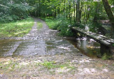
globalement c'est une belle balade. Mais le depart et le retour via le zoning industriel et en longeant les grandes routes est assez deprimant. a ameliorer via un autre chemin.
Trop souvent sur la route ou sentier asphalté, et fort fréquenté...
dommage de venir dans cette belle région pour faire 90 % de tarmac
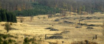
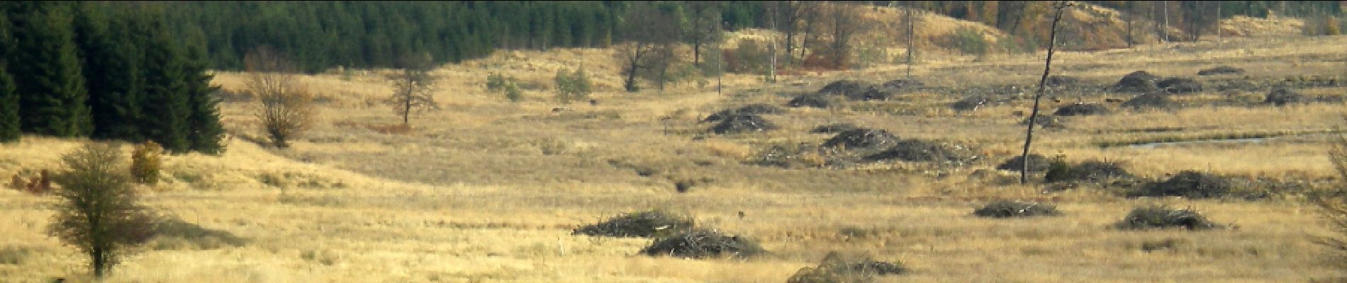
Très belle randonnée sur les hauteurs, de beaux panoramas à voir
top
ce parcours est magnifique, notamment la partie dans la forêt de Saint Hubert ou celle près du monastère d'hurtebise, dans lequel il faut s'arrêter. mais les passages près des bretelles d'autoroutes sont assez dangereux et peu agréables, de même que la route asphaltee vers l'aéroport, car les voitures y roulent fort vite.
super handig