![](/images/other/stat-length.png)
![Percorso Marcia Perros-Guirec - Le Sentier des Douaniers à Perros-Guirec - Photo](https://media.geolcdn.com/t/1900/400/ext.pjpeg?maxdim=2&url=https%3A%2F%2Fservices.sitytrail.com%2FGeolivesWS%2FDownloadMedia.ashx%3FTrailID%3D317020%26Media%3D16162_5.jpg)
Le Sentier des Douaniers à Perros-Guirec
tracegps
Utente
![Lunghezza](/images/other/stat-length.png)
Lunghezza
8,1 km
![Altitudine massima](https://static1.geolcdn.com/siteimages/upload/files/1508320355ic_sort_altitude_max_24dp.png)
Altitudine massima
59 m
![Dislivello positivo](https://static1.geolcdn.com/siteimages/upload/files/1508320355ic_sort_den_pos_24dp.png)
Dislivello positivo
127 m
![Km-Effort](/images/other/stat-length.png)
Km-Effort
9,9 km
![Altitudine minima](https://static1.geolcdn.com/siteimages/upload/files/1508320355ic_sort_altitude_min_24dp.png)
Altitudine minima
-1 m
![Dislivello negativo](https://static1.geolcdn.com/siteimages/upload/files/1508320355ic_sort_den_neg_24dp.png)
Dislivello negativo
146 m
![Boucle](https://static1.geolcdn.com/siteimages/upload/files/16400158638029165_repeat_loop_refresh_sync_direction_icon.png)
Boucle
No
Data di creazione :
2014-12-10 00:00:00.0
Ultima modifica :
2014-12-10 00:00:00.0
![Marcia](https://static1.geolcdn.com/sitytour/trail-icons/101.png)
2h30
Difficoltà : Medio
![Scannerizza questo codice QR per aprire il percorso nell'applicazione SityTrail](https://capi.geolives.com/qq0zvz2zws4bq2lad0pu/sitytour/trails/317020/qr.png?size=200)
Applicazione GPS da escursionismo GRATUITA
Chi siamo
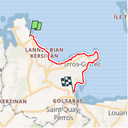
Percorso Marcia di 8,1 km da scoprire a Bretagna, Côtes-d'Armor, Perros-Guirec. Questo percorso è proposto da tracegps.
Descrizione
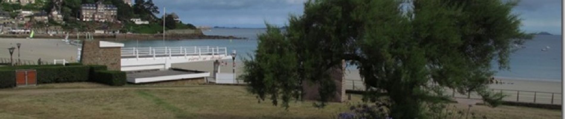
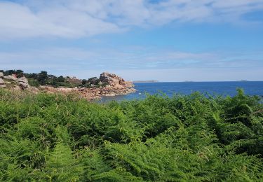
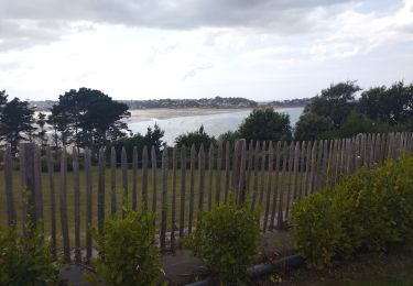
Très jolie promenade sur le Sentier des Douaniers. Vue sur la mer et découverte sur le chemin d'une superbe plage avec ses commerces (Trestaou).
Localizzazione
Paese:
France
Regione :
Bretagna
Dipartimento/Provincia :
Côtes-d'Armor
Comune :
Perros-Guirec
Località :
Unknown
Partenza:(Dec)
Partenza:(UTM)
465199 ; 5408376 (30U) N.
Commenti
Percorsi nelle vicinanze
![Percorso Marcia Perros-Guirec - Perros-Guirec - GR34 - 11.1km 185m 2h50 - 2023 09 08 - Photo](https://media.geolcdn.com/t/375/260/d1728063-b6c3-4241-bba7-0eab61cebb20.jpg&format=jpg&maxdim=2)
![Marcia Marcia](https://static1.geolcdn.com/sitytour/trail-icons/101.png)
Perros-Guirec - GR34 - 11.1km 185m 2h50 - 2023 09 08
Marcia
Medio
(1)
Perros-Guirec,
Bretagna,
Côtes-d'Armor,
France
![](/images/other/stat-length.png)
11,1 km | 13,6 km-effort
2h 50min
![](https://static1.geolcdn.com/siteimages/upload/files/16400158638029165_repeat_loop_refresh_sync_direction_icon.png)
Sì
![Percorso Marcia Trégastel - Trégastel - GR34 Île Renote Moulin à marée Chapelle de Gorgon - 13.8km 100m 3h35 - 2023 09 07 - Photo](https://media.geolcdn.com/t/375/260/f7b585bc-cd92-4f03-b6f8-635e10f5e6be.jpg&format=jpg&maxdim=2)
![Marcia Marcia](https://static1.geolcdn.com/sitytour/trail-icons/101.png)
Trégastel - GR34 Île Renote Moulin à marée Chapelle de Gorgon - 13.8km 100m 3...
Marcia
Difficile
(2)
Trégastel,
Bretagna,
Côtes-d'Armor,
France
![](/images/other/stat-length.png)
13,8 km | 15,1 km-effort
3h 35min
![](https://static1.geolcdn.com/siteimages/upload/files/16400158638029165_repeat_loop_refresh_sync_direction_icon.png)
Sì
![Percorso Marcia Perros-Guirec - la côte de granit rose à Ploumanach - Photo](https://media.geolcdn.com/t/375/260/64deb34e-d59c-4f9a-95ec-bcb98ff541ad.jpg&format=jpg&maxdim=2)
![Marcia Marcia](https://static1.geolcdn.com/sitytour/trail-icons/101.png)
la côte de granit rose à Ploumanach
Marcia
Molto facile
(2)
Perros-Guirec,
Bretagna,
Côtes-d'Armor,
France
![](/images/other/stat-length.png)
6 km | 6,9 km-effort
2h 38min
![](https://static1.geolcdn.com/siteimages/upload/files/16400158638029165_repeat_loop_refresh_sync_direction_icon.png)
Sì
![Percorso Marcia Perros-Guirec - Les sentiers de Ploumanac'h - Photo](https://media.geolcdn.com/t/375/260/ext.jpg?maxdim=2&url=https%3A%2F%2Fservices.sitytrail.com%2FGeolivesWS%2FDownloadMedia.ashx%3FTrailID%3D317019%26Media%3D16161_1.jpg)
![Marcia Marcia](https://static1.geolcdn.com/sitytour/trail-icons/101.png)
Les sentiers de Ploumanac'h
Marcia
Medio
(2)
Perros-Guirec,
Bretagna,
Côtes-d'Armor,
France
![](/images/other/stat-length.png)
10,3 km | 12 km-effort
3h 0min
![](https://static1.geolcdn.com/siteimages/upload/files/16400158638029165_repeat_loop_refresh_sync_direction_icon.png)
Sì
![Percorso Marcia Louannec - Louannec - GR34 PR - 11.5km 185m 3h00 (40mn) - 2023 09 14 - Photo](https://media.geolcdn.com/t/375/260/e980ede6-67ca-4aa3-94c9-619423761500.jpg&format=jpg&maxdim=2)
![Marcia Marcia](https://static1.geolcdn.com/sitytour/trail-icons/101.png)
Louannec - GR34 PR - 11.5km 185m 3h00 (40mn) - 2023 09 14
Marcia
Difficile
Louannec,
Bretagna,
Côtes-d'Armor,
France
![](/images/other/stat-length.png)
11,5 km | 13,9 km-effort
3h 0min
![](https://static1.geolcdn.com/siteimages/upload/files/16400158638029165_repeat_loop_refresh_sync_direction_icon.png)
Sì
![Percorso Marcia Trégastel - Trégastel - GR34 Ploumanac'h Kasino de Perros-Guirec - 11.7km 200m 2h55 (50mn) - 2023 09 08 - Photo](https://media.geolcdn.com/t/375/260/3132b43e-4920-4682-bf35-15b1d429cbae.jpg&format=jpg&maxdim=2)
![Marcia Marcia](https://static1.geolcdn.com/sitytour/trail-icons/101.png)
Trégastel - GR34 Ploumanac'h Kasino de Perros-Guirec - 11.7km 200m 2h55 (50mn...
Marcia
Medio
Trégastel,
Bretagna,
Côtes-d'Armor,
France
![](/images/other/stat-length.png)
11,7 km | 14,4 km-effort
2h 55min
![](https://static1.geolcdn.com/siteimages/upload/files/16400158638029165_repeat_loop_refresh_sync_direction_icon.png)
Sì
![Percorso Marcia Pleumeur-Bodou - Pleumeur-Bodou - GR34 Chapelle Saint-Samson - 7.7km 60m 1h55 - 2023 09 06 - Photo](https://media.geolcdn.com/t/375/260/5d74374c-67e8-400e-845c-98d92708147a.jpg&format=jpg&maxdim=2)
![Marcia Marcia](https://static1.geolcdn.com/sitytour/trail-icons/101.png)
Pleumeur-Bodou - GR34 Chapelle Saint-Samson - 7.7km 60m 1h55 - 2023 09 06
Marcia
Medio
Pleumeur-Bodou,
Bretagna,
Côtes-d'Armor,
France
![](/images/other/stat-length.png)
7,7 km | 8,5 km-effort
1h 55min
![](https://static1.geolcdn.com/siteimages/upload/files/16400158638029165_repeat_loop_refresh_sync_direction_icon.png)
Sì
![Percorso Cicloturismo Pleumeur-Bodou - Landrellec à kercoz - Photo](https://media.geolcdn.com/t/375/260/9edc18fe-d348-4dcd-a457-97cbb66b8768.jpg&format=jpg&maxdim=2)
![Cicloturismo Cicloturismo](https://static1.geolcdn.com/sitytour/trail-icons/204.png)
Landrellec à kercoz
Cicloturismo
Facile
Pleumeur-Bodou,
Bretagna,
Côtes-d'Armor,
France
![](/images/other/stat-length.png)
52 km | 61 km-effort
4h 19min
![](https://static1.geolcdn.com/siteimages/upload/files/16400158638029165_repeat_loop_refresh_sync_direction_icon.png)
No
![Percorso Marcia Trégastel - GR34-EtapeIII-J05 - Photo](https://media.geolcdn.com/t/375/260/ext.jpg?maxdim=2&url=https%3A%2F%2Fstatic1.geolcdn.com%2Fsiteimages%2Fupload%2Ffiles%2F1553511878bg_sport_marche.png)
![Marcia Marcia](https://static1.geolcdn.com/sitytour/trail-icons/101.png)
GR34-EtapeIII-J05
Marcia
Facile
(1)
Trégastel,
Bretagna,
Côtes-d'Armor,
France
![](/images/other/stat-length.png)
19,2 km | 21 km-effort
6h 30min
![](https://static1.geolcdn.com/siteimages/upload/files/16400158638029165_repeat_loop_refresh_sync_direction_icon.png)
No