![](/images/other/stat-length.png)
![Percorso A piedi Clausthal-Zellerfeld - Goetheweg - Photo](https://media.geolcdn.com/t/1900/400/ext.pjpeg?maxdim=2&url=https%3A%2F%2Fstatic1.geolcdn.com%2Fsiteimages%2Fupload%2Ffiles%2F1545311037marcheuse_200dpi.jpg)
Goetheweg
SityTrail - itinéraires balisés pédestres
Tous les sentiers balisés d’Europe GUIDE+
![Lunghezza](/images/other/stat-length.png)
Lunghezza
8,6 km
![Altitudine massima](https://static1.geolcdn.com/siteimages/upload/files/1508320355ic_sort_altitude_max_24dp.png)
Altitudine massima
1140 m
![Dislivello positivo](https://static1.geolcdn.com/siteimages/upload/files/1508320355ic_sort_den_pos_24dp.png)
Dislivello positivo
350 m
![Km-Effort](/images/other/stat-length.png)
Km-Effort
12,1 km
![Altitudine minima](https://static1.geolcdn.com/siteimages/upload/files/1508320355ic_sort_altitude_min_24dp.png)
Altitudine minima
796 m
![Dislivello negativo](https://static1.geolcdn.com/siteimages/upload/files/1508320355ic_sort_den_neg_24dp.png)
Dislivello negativo
17 m
![Boucle](https://static1.geolcdn.com/siteimages/upload/files/16400158638029165_repeat_loop_refresh_sync_direction_icon.png)
Boucle
No
Tag
Data di creazione :
2022-02-21 08:17:43.039
Ultima modifica :
2022-02-21 08:17:43.039
![A piedi](https://static1.geolcdn.com/sitytour/trail-icons/100.png)
2h45
Difficoltà : Facile
![Scannerizza questo codice QR per aprire il percorso nell'applicazione SityTrail](https://capi.geolives.com/qq0zvz2zws4bq2lad0pu/sitytour/trails/3136603/qr.png?size=200)
Applicazione GPS da escursionismo GRATUITA
Chi siamo
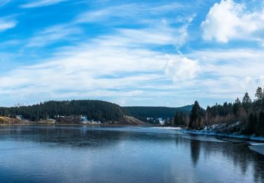
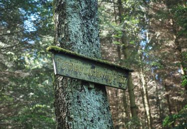
Percorso A piedi di 8,6 km da scoprire a Niedersachsen, Landkreis Goslar, Clausthal-Zellerfeld. Questo percorso è proposto da SityTrail - itinéraires balisés pédestres.
Descrizione
Nationalpark Harz
Sito web: https://www.nationalpark-harz.de/de/downloads/wanderwege/?we_objectID=456&refDID=3495
Localizzazione
Paese:
Germany
Regione :
Niedersachsen
Dipartimento/Provincia :
Landkreis Goslar
Comune :
Clausthal-Zellerfeld
Località :
Altenau - Schulenberg i.O.
Partenza:(Dec)
Partenza:(UTM)
605991 ; 5740196 (32U) N.
Commenti
Percorsi nelle vicinanze
![Percorso A piedi Harz (LK Goslar) - HK 7: Bad Grund - Okertal - Bad Harzburg - Photo](https://media.geolcdn.com/t/375/260/5ec67649-2277-4b30-b807-d8796dff005f.jpeg&format=jpg&maxdim=2)
![A piedi A piedi](https://static1.geolcdn.com/sitytour/trail-icons/100.png)
HK 7: Bad Grund - Okertal - Bad Harzburg
A piedi
Facile
Harz (LK Goslar),
Niedersachsen,
Landkreis Goslar,
Germany
![](/images/other/stat-length.png)
7,8 km | 10,1 km-effort
2h 18min
![](https://static1.geolcdn.com/siteimages/upload/files/16400158638029165_repeat_loop_refresh_sync_direction_icon.png)
No
![Percorso A piedi Clausthal-Zellerfeld - Rund um das Große Torfhausmoor - Photo](https://media.geolcdn.com/t/375/260/2f3d7e96-7e4b-4b83-b692-89c4b1b12b00.jpeg&format=jpg&maxdim=2)
![A piedi A piedi](https://static1.geolcdn.com/sitytour/trail-icons/100.png)
Rund um das Große Torfhausmoor
A piedi
Facile
Clausthal-Zellerfeld,
Niedersachsen,
Landkreis Goslar,
Germany
![](/images/other/stat-length.png)
4,9 km | 6 km-effort
1h 22min
![](https://static1.geolcdn.com/siteimages/upload/files/16400158638029165_repeat_loop_refresh_sync_direction_icon.png)
No
![Percorso A piedi Harz (LK Goslar) - Eckertalsperren-Rundweg - Photo](https://media.geolcdn.com/t/375/260/5c9ed9cb-b69d-4e8f-93d8-96beb9994ac2.jpeg&format=jpg&maxdim=2)
![A piedi A piedi](https://static1.geolcdn.com/sitytour/trail-icons/100.png)
Eckertalsperren-Rundweg
A piedi
Facile
Harz (LK Goslar),
Niedersachsen,
Landkreis Goslar,
Germany
![](/images/other/stat-length.png)
8,5 km | 10,4 km-effort
2h 21min
![](https://static1.geolcdn.com/siteimages/upload/files/16400158638029165_repeat_loop_refresh_sync_direction_icon.png)
Sì
![Percorso A piedi Harz (LK Goslar) - Harzklub-Weg 10G - Photo](https://media.geolcdn.com/t/375/260/3bff2b33-6ce0-4f45-be60-b11e4df98e90.jpeg&format=jpg&maxdim=2)
![A piedi A piedi](https://static1.geolcdn.com/sitytour/trail-icons/100.png)
Harzklub-Weg 10G
A piedi
Facile
Harz (LK Goslar),
Niedersachsen,
Landkreis Goslar,
Germany
![](/images/other/stat-length.png)
3,3 km | 3,8 km-effort
52min
![](https://static1.geolcdn.com/siteimages/upload/files/16400158638029165_repeat_loop_refresh_sync_direction_icon.png)
No
![Percorso A piedi Harz (LK Goslar) - Rehberger Graben - Photo](https://media.geolcdn.com/t/375/260/ext.jpg?maxdim=2&url=https%3A%2F%2Fstatic1.geolcdn.com%2Fsiteimages%2Fupload%2Ffiles%2F1545311037marcheuse_200dpi.jpg)
![A piedi A piedi](https://static1.geolcdn.com/sitytour/trail-icons/100.png)
Rehberger Graben
A piedi
Facile
Harz (LK Goslar),
Niedersachsen,
Landkreis Goslar,
Germany
![](/images/other/stat-length.png)
7,4 km | 8,9 km-effort
2h 1min
![](https://static1.geolcdn.com/siteimages/upload/files/16400158638029165_repeat_loop_refresh_sync_direction_icon.png)
No
![Percorso Sentiero Harz (LK Goslar) - Tarfhaus - Photo](https://media.geolcdn.com/t/375/260/ext.jpg?maxdim=2&url=https%3A%2F%2Fstatic1.geolcdn.com%2Fsiteimages%2Fupload%2Ffiles%2F1524743154running.jpg)
![Sentiero Sentiero](https://static1.geolcdn.com/sitytour/trail-icons/104.png)
Tarfhaus
Sentiero
Facile
Harz (LK Goslar),
Niedersachsen,
Landkreis Goslar,
Germany
![](/images/other/stat-length.png)
9,7 km | 14,1 km-effort
1h 15min
![](https://static1.geolcdn.com/siteimages/upload/files/16400158638029165_repeat_loop_refresh_sync_direction_icon.png)
No
![Percorso Marcia Clausthal-Zellerfeld - tarfhaismoor - Photo](https://media.geolcdn.com/t/375/260/ext.jpg?maxdim=2&url=https%3A%2F%2Fstatic1.geolcdn.com%2Fsiteimages%2Fupload%2Ffiles%2F1553511878bg_sport_marche.png)
![Marcia Marcia](https://static1.geolcdn.com/sitytour/trail-icons/101.png)
tarfhaismoor
Marcia
Molto facile
Clausthal-Zellerfeld,
Niedersachsen,
Landkreis Goslar,
Germany
![](/images/other/stat-length.png)
5,5 km | 6,8 km-effort
1h 32min
![](https://static1.geolcdn.com/siteimages/upload/files/16400158638029165_repeat_loop_refresh_sync_direction_icon.png)
Sì
![Percorso Mountainbike Clausthal-Zellerfeld - Broken - Photo](https://media.geolcdn.com/t/375/260/ext.jpg?maxdim=2&url=https%3A%2F%2Fstatic1.geolcdn.com%2Fsiteimages%2Fupload%2Ffiles%2F1524743154velo.jpg)
![Mountainbike Mountainbike](https://static1.geolcdn.com/sitytour/trail-icons/202.png)
Broken
Mountainbike
Difficile
Clausthal-Zellerfeld,
Niedersachsen,
Landkreis Goslar,
Germany
![](/images/other/stat-length.png)
51 km | 68 km-effort
5h 12min
![](https://static1.geolcdn.com/siteimages/upload/files/16400158638029165_repeat_loop_refresh_sync_direction_icon.png)
Sì