![](/images/other/stat-length.png)
![Percorso A piedi Greinbach - Penzendorf Wanderweg 8 - Photo](https://media.geolcdn.com/t/1900/400/d692d0d6-d9fb-4e98-b02b-1feb77799686.jpeg&format=pjpeg&maxdim=2)
Penzendorf Wanderweg 8
SityTrail - itinéraires balisés pédestres
Tous les sentiers balisés d’Europe GUIDE+
![Lunghezza](/images/other/stat-length.png)
Lunghezza
5,3 km
![Altitudine massima](https://static1.geolcdn.com/siteimages/upload/files/1508320355ic_sort_altitude_max_24dp.png)
Altitudine massima
928 m
![Dislivello positivo](https://static1.geolcdn.com/siteimages/upload/files/1508320355ic_sort_den_pos_24dp.png)
Dislivello positivo
62 m
![Km-Effort](/images/other/stat-length.png)
Km-Effort
7 km
![Altitudine minima](https://static1.geolcdn.com/siteimages/upload/files/1508320355ic_sort_altitude_min_24dp.png)
Altitudine minima
633 m
![Dislivello negativo](https://static1.geolcdn.com/siteimages/upload/files/1508320355ic_sort_den_neg_24dp.png)
Dislivello negativo
332 m
![Boucle](https://static1.geolcdn.com/siteimages/upload/files/16400158638029165_repeat_loop_refresh_sync_direction_icon.png)
Boucle
No
Tag
Data di creazione :
2022-02-16 16:54:50.915
Ultima modifica :
2022-03-03 13:53:16.785
![A piedi](https://static1.geolcdn.com/sitytour/trail-icons/100.png)
1h35
Difficoltà : Facile
![Scannerizza questo codice QR per aprire il percorso nell'applicazione SityTrail](https://capi.geolives.com/qq0zvz2zws4bq2lad0pu/sitytour/trails/3128266/qr.png?size=200)
Applicazione GPS da escursionismo GRATUITA
Chi siamo
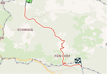
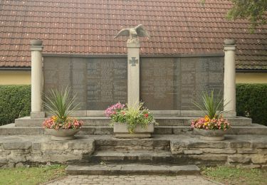
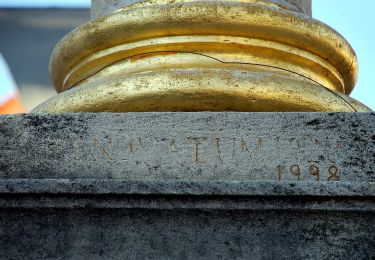
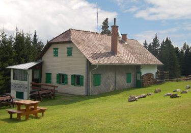
Percorso A piedi di 5,3 km da scoprire a Stiria, Bezirk Hartberg-Fürstenfeld, Greinbach. Questo percorso è proposto da SityTrail - itinéraires balisés pédestres.
Descrizione
Trail created by Steirische Berg und Naturwacht Orsteinsatzstelle Hartberg.
Symbol: blau-weiss-blau 8
Localizzazione
Paese:
Austria
Regione :
Stiria
Dipartimento/Provincia :
Bezirk Hartberg-Fürstenfeld
Comune :
Greinbach
Località :
Unknown
Partenza:(Dec)
Partenza:(UTM)
568886 ; 5241811 (33T) N.
Commenti
Percorsi nelle vicinanze
![Percorso A piedi Grafendorf bei Hartberg - Stambach Weg 1 - Photo](https://media.geolcdn.com/t/375/260/c62fbda3-1413-4d24-97ed-ac34e183a5b7.jpeg&format=jpg&maxdim=2)
![A piedi A piedi](https://static1.geolcdn.com/sitytour/trail-icons/100.png)
Stambach Weg 1
A piedi
Facile
Grafendorf bei Hartberg,
Stiria,
Bezirk Hartberg-Fürstenfeld,
Austria
![](/images/other/stat-length.png)
10 km | 16,3 km-effort
3h 41min
![](https://static1.geolcdn.com/siteimages/upload/files/16400158638029165_repeat_loop_refresh_sync_direction_icon.png)
Sì
![Percorso A piedi Grafendorf bei Hartberg - Stambach Weg 4 - Photo](https://media.geolcdn.com/t/375/260/6cd60473-fc2c-43f7-8f1a-26a1b64a16ff.jpeg&format=jpg&maxdim=2)
![A piedi A piedi](https://static1.geolcdn.com/sitytour/trail-icons/100.png)
Stambach Weg 4
A piedi
Facile
Grafendorf bei Hartberg,
Stiria,
Bezirk Hartberg-Fürstenfeld,
Austria
![](/images/other/stat-length.png)
4,6 km | 7,1 km-effort
1h 37min
![](https://static1.geolcdn.com/siteimages/upload/files/16400158638029165_repeat_loop_refresh_sync_direction_icon.png)
Sì
![Percorso A piedi Grafendorf bei Hartberg - Stambach Weg 14 - Photo](https://media.geolcdn.com/t/375/260/c62fbda3-1413-4d24-97ed-ac34e183a5b7.jpeg&format=jpg&maxdim=2)
![A piedi A piedi](https://static1.geolcdn.com/sitytour/trail-icons/100.png)
Stambach Weg 14
A piedi
Facile
Grafendorf bei Hartberg,
Stiria,
Bezirk Hartberg-Fürstenfeld,
Austria
![](/images/other/stat-length.png)
4,9 km | 7,6 km-effort
1h 43min
![](https://static1.geolcdn.com/siteimages/upload/files/16400158638029165_repeat_loop_refresh_sync_direction_icon.png)
Sì
![Percorso A piedi Vorau - Pankaratiusweg Pöllauberg - Vorau - Photo](https://media.geolcdn.com/t/375/260/feffc530-8690-488d-aea3-dd878ee854a5.jpeg&format=jpg&maxdim=2)
![A piedi A piedi](https://static1.geolcdn.com/sitytour/trail-icons/100.png)
Pankaratiusweg Pöllauberg - Vorau
A piedi
Facile
Vorau,
Stiria,
Bezirk Hartberg-Fürstenfeld,
Austria
![](/images/other/stat-length.png)
12,6 km | 18,2 km-effort
4h 8min
![](https://static1.geolcdn.com/siteimages/upload/files/16400158638029165_repeat_loop_refresh_sync_direction_icon.png)
No
![Percorso A piedi Pöllauberg - Grafendorf Masenberg Weg 18 - Photo](https://media.geolcdn.com/t/375/260/deb6a9f4-4a39-45a6-a3ce-260c78519870.jpeg&format=jpg&maxdim=2)
![A piedi A piedi](https://static1.geolcdn.com/sitytour/trail-icons/100.png)
Grafendorf Masenberg Weg 18
A piedi
Facile
Pöllauberg,
Stiria,
Bezirk Hartberg-Fürstenfeld,
Austria
![](/images/other/stat-length.png)
12,5 km | 15,9 km-effort
3h 36min
![](https://static1.geolcdn.com/siteimages/upload/files/16400158638029165_repeat_loop_refresh_sync_direction_icon.png)
No
![Percorso A piedi Pöllauberg - Grafendorf Masenberg Weg 17 - Photo](https://media.geolcdn.com/t/375/260/deb6a9f4-4a39-45a6-a3ce-260c78519870.jpeg&format=jpg&maxdim=2)
![A piedi A piedi](https://static1.geolcdn.com/sitytour/trail-icons/100.png)
Grafendorf Masenberg Weg 17
A piedi
Facile
Pöllauberg,
Stiria,
Bezirk Hartberg-Fürstenfeld,
Austria
![](/images/other/stat-length.png)
12,2 km | 15,4 km-effort
3h 29min
![](https://static1.geolcdn.com/siteimages/upload/files/16400158638029165_repeat_loop_refresh_sync_direction_icon.png)
No
![Percorso A piedi Hartberg - Ringwarte Brühl Spielstätte - Photo](https://media.geolcdn.com/t/375/260/20adf768-0326-43f9-a7e2-11fb5c56a5e5.jpeg&format=jpg&maxdim=2)
![A piedi A piedi](https://static1.geolcdn.com/sitytour/trail-icons/100.png)
Ringwarte Brühl Spielstätte
A piedi
Facile
Hartberg,
Stiria,
Bezirk Hartberg-Fürstenfeld,
Austria
![](/images/other/stat-length.png)
4,6 km | 6,1 km-effort
1h 23min
![](https://static1.geolcdn.com/siteimages/upload/files/16400158638029165_repeat_loop_refresh_sync_direction_icon.png)
No
![Percorso A piedi Pöllauberg - Waldlehrpfad Masenberg - Photo](https://media.geolcdn.com/t/375/260/927723a2-70f8-4695-954c-391eddc5a724.jpeg&format=jpg&maxdim=2)
![A piedi A piedi](https://static1.geolcdn.com/sitytour/trail-icons/100.png)
Waldlehrpfad Masenberg
A piedi
Facile
Pöllauberg,
Stiria,
Bezirk Hartberg-Fürstenfeld,
Austria
![](/images/other/stat-length.png)
4,5 km | 7,6 km-effort
1h 44min
![](https://static1.geolcdn.com/siteimages/upload/files/16400158638029165_repeat_loop_refresh_sync_direction_icon.png)
No
![Percorso A piedi Grafendorf bei Hartberg - Penzendorf Wanderweg 8a - Photo](https://media.geolcdn.com/t/375/260/6cd60473-fc2c-43f7-8f1a-26a1b64a16ff.jpeg&format=jpg&maxdim=2)
![A piedi A piedi](https://static1.geolcdn.com/sitytour/trail-icons/100.png)
Penzendorf Wanderweg 8a
A piedi
Facile
Grafendorf bei Hartberg,
Stiria,
Bezirk Hartberg-Fürstenfeld,
Austria
![](/images/other/stat-length.png)
3,9 km | 5,8 km-effort
1h 18min
![](https://static1.geolcdn.com/siteimages/upload/files/16400158638029165_repeat_loop_refresh_sync_direction_icon.png)
No