![](/images/other/stat-length.png)
![Percorso A piedi Gemeinde Enzesfeld-Lindabrunn - Lindabrunn - Piesting - Photo](https://media.geolcdn.com/t/1900/400/ext.pjpeg?maxdim=2&url=https%3A%2F%2Fmedia.geolcdn.com%2Ff%2F8d72710b-9375-4484-9d46-f122098df0b3.jpeg)
Lindabrunn - Piesting
SityTrail - itinéraires balisés pédestres
Tous les sentiers balisés d’Europe PRO
![Lunghezza](/images/other/stat-length.png)
Lunghezza
5,3 km
![Altitudine massima](https://static1.geolcdn.com/siteimages/upload/files/1508320355ic_sort_altitude_max_24dp.png)
Altitudine massima
501 m
![Dislivello positivo](https://static1.geolcdn.com/siteimages/upload/files/1508320355ic_sort_den_pos_24dp.png)
Dislivello positivo
177 m
![Km-Effort](/images/other/stat-length.png)
Km-Effort
7,6 km
![Altitudine minima](https://static1.geolcdn.com/siteimages/upload/files/1508320355ic_sort_altitude_min_24dp.png)
Altitudine minima
338 m
![Dislivello negativo](https://static1.geolcdn.com/siteimages/upload/files/1508320355ic_sort_den_neg_24dp.png)
Dislivello negativo
156 m
![Boucle](https://static1.geolcdn.com/siteimages/upload/files/16400158638029165_repeat_loop_refresh_sync_direction_icon.png)
Boucle
No
Tag
Data di creazione :
2022-02-16 16:08:55.975
Ultima modifica :
2022-03-03 02:26:19.043
![A piedi](https://static1.geolcdn.com/sitytour/trail-icons/100.png)
1h43
Difficoltà : Facile
![Scannerizza questo codice QR per aprire il percorso nell'applicazione SityTrail](https://capi.geolives.com/qq0zvz2zws4bq2lad0pu/sitytour/trails/3126120/qr.png?size=200)
Applicazione GPS da escursionismo GRATUITA
Chi siamo
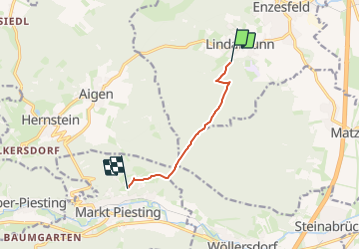
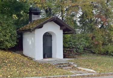
Percorso A piedi di 5,3 km da scoprire a Bassa Austria, Bezirk Baden, Gemeinde Enzesfeld-Lindabrunn. Questo percorso è proposto da SityTrail - itinéraires balisés pédestres.
Descrizione
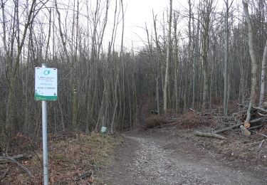
Trail created by Österreichischer Touristenklub, Sektion Triestingtal.
Symbol: roter, waagrechter Balken
Localizzazione
Paese:
Austria
Regione :
Bassa Austria
Dipartimento/Provincia :
Bezirk Baden
Comune :
Gemeinde Enzesfeld-Lindabrunn
Località :
Unknown
Partenza:(Dec)
Partenza:(UTM)
587299 ; 5306751 (33T) N.
Commenti
Percorsi nelle vicinanze
![Percorso A piedi Gemeinde Berndorf - St.Veit/Triesting (Hst.ÖBB) - Hirtenberg - Großau - Photo](https://media.geolcdn.com/t/375/260/ext.jpg?maxdim=2&url=https%3A%2F%2Fmedia.geolcdn.com%2Ff%2Fb2ff8fd8-3889-4de0-8f86-6deee493a5ce.jpeg)
![A piedi A piedi](https://static1.geolcdn.com/sitytour/trail-icons/100.png)
St.Veit/Triesting (Hst.ÖBB) - Hirtenberg - Großau
A piedi
Facile
Gemeinde Berndorf,
Bassa Austria,
Bezirk Baden,
Austria
![](/images/other/stat-length.png)
5,7 km | 7,5 km-effort
1h 41min
![](https://static1.geolcdn.com/siteimages/upload/files/16400158638029165_repeat_loop_refresh_sync_direction_icon.png)
No
![Percorso A piedi Gemeinde Berndorf - Lindenberg - Großau - Vöslauerhütte - Photo](https://media.geolcdn.com/t/375/260/ext.jpg?maxdim=2&url=https%3A%2F%2Fmedia.geolcdn.com%2Ff%2F9e9e7942-699a-4508-b2d6-e5f8e665eaab.jpeg)
![A piedi A piedi](https://static1.geolcdn.com/sitytour/trail-icons/100.png)
Lindenberg - Großau - Vöslauerhütte
A piedi
Facile
Gemeinde Berndorf,
Bassa Austria,
Bezirk Baden,
Austria
![](/images/other/stat-length.png)
5 km | 7,2 km-effort
1h 37min
![](https://static1.geolcdn.com/siteimages/upload/files/16400158638029165_repeat_loop_refresh_sync_direction_icon.png)
No
![Percorso A piedi Kottingbrunn - Laufend geniessen (Höllrigl Kottingbrunn) - Photo](https://media.geolcdn.com/t/375/260/ext.jpg?maxdim=2&url=https%3A%2F%2Fmedia.geolcdn.com%2Ff%2F072190bf-039e-45c2-ac1a-47a3071ac183.jpeg)
![A piedi A piedi](https://static1.geolcdn.com/sitytour/trail-icons/100.png)
Laufend geniessen (Höllrigl Kottingbrunn)
A piedi
Facile
Kottingbrunn,
Bassa Austria,
Bezirk Baden,
Austria
![](/images/other/stat-length.png)
5,3 km | 5,8 km-effort
1h 19min
![](https://static1.geolcdn.com/siteimages/upload/files/16400158638029165_repeat_loop_refresh_sync_direction_icon.png)
Sì
![Percorso A piedi Gemeinde Hernstein - Auf dem Hart (Ergänzung zum Wanderweg 4) - Photo](https://media.geolcdn.com/t/375/260/ext.jpg?maxdim=2&url=https%3A%2F%2Fmedia.geolcdn.com%2Ff%2Fbdfde13c-1a23-460f-9e17-c8b8f1d1c67c.jpeg)
![A piedi A piedi](https://static1.geolcdn.com/sitytour/trail-icons/100.png)
Auf dem Hart (Ergänzung zum Wanderweg 4)
A piedi
Facile
Gemeinde Hernstein,
Bassa Austria,
Bezirk Baden,
Austria
![](/images/other/stat-length.png)
3,7 km | 4,1 km-effort
56min
![](https://static1.geolcdn.com/siteimages/upload/files/16400158638029165_repeat_loop_refresh_sync_direction_icon.png)
No
![Percorso A piedi Gemeinde Berndorf - Berndorf - Hoher Lindkogel - Photo](https://media.geolcdn.com/t/375/260/ext.jpg?maxdim=2&url=https%3A%2F%2Fmedia.geolcdn.com%2Ff%2Ff28711c1-c58f-44b3-bc80-6633d2190f0e.jpeg)
![A piedi A piedi](https://static1.geolcdn.com/sitytour/trail-icons/100.png)
Berndorf - Hoher Lindkogel
A piedi
Facile
Gemeinde Berndorf,
Bassa Austria,
Bezirk Baden,
Austria
![](/images/other/stat-length.png)
9,7 km | 16,8 km-effort
3h 48min
![](https://static1.geolcdn.com/siteimages/upload/files/16400158638029165_repeat_loop_refresh_sync_direction_icon.png)
No
![Percorso A piedi Gemeinde Berndorf - Berndorf Runde - Photo](https://media.geolcdn.com/t/375/260/ext.jpg?maxdim=2&url=https%3A%2F%2Fmedia.geolcdn.com%2Ff%2F6a62f1c4-b11c-465b-959f-5b4bb61832ea.jpeg)
![A piedi A piedi](https://static1.geolcdn.com/sitytour/trail-icons/100.png)
Berndorf Runde
A piedi
Facile
Gemeinde Berndorf,
Bassa Austria,
Bezirk Baden,
Austria
![](/images/other/stat-length.png)
9,3 km | 11,5 km-effort
2h 36min
![](https://static1.geolcdn.com/siteimages/upload/files/16400158638029165_repeat_loop_refresh_sync_direction_icon.png)
Sì
![Percorso A piedi Gemeinde Berndorf - Arthur Krupp Runde (Berndorf) - Photo](https://media.geolcdn.com/t/375/260/ext.jpg?maxdim=2&url=https%3A%2F%2Fmedia.geolcdn.com%2Ff%2F16dd14be-fc53-49db-8e00-2a3ab7b7a7f0.jpeg)
![A piedi A piedi](https://static1.geolcdn.com/sitytour/trail-icons/100.png)
Arthur Krupp Runde (Berndorf)
A piedi
Facile
Gemeinde Berndorf,
Bassa Austria,
Bezirk Baden,
Austria
![](/images/other/stat-length.png)
6,3 km | 8,8 km-effort
2h 0min
![](https://static1.geolcdn.com/siteimages/upload/files/16400158638029165_repeat_loop_refresh_sync_direction_icon.png)
No
![Percorso A piedi Gemeinde Piesting - Markt Piesting - Alkersdorf - Mühltal - Oberpiesting - Photo](https://media.geolcdn.com/t/375/260/ext.jpg?maxdim=2&url=https%3A%2F%2Fmedia.geolcdn.com%2Ff%2Fda4e84a1-619a-4126-b958-37ccde8f4cf9.jpeg)
![A piedi A piedi](https://static1.geolcdn.com/sitytour/trail-icons/100.png)
Markt Piesting - Alkersdorf - Mühltal - Oberpiesting
A piedi
Facile
Gemeinde Piesting,
Bassa Austria,
Bezirk Wiener Neustadt,
Austria
![](/images/other/stat-length.png)
4,9 km | 7,9 km-effort
1h 48min
![](https://static1.geolcdn.com/siteimages/upload/files/16400158638029165_repeat_loop_refresh_sync_direction_icon.png)
No
![Percorso A piedi Gemeinde Piesting - Markt Piesting Waldbad - Zitterwirt - Piesting B21 - Photo](https://media.geolcdn.com/t/375/260/ext.jpg?maxdim=2&url=https%3A%2F%2Fmedia.geolcdn.com%2Ff%2F3d6a13ac-18b3-4b71-9d85-8941251c398b.jpeg)
![A piedi A piedi](https://static1.geolcdn.com/sitytour/trail-icons/100.png)
Markt Piesting Waldbad - Zitterwirt - Piesting B21
A piedi
Facile
Gemeinde Piesting,
Bassa Austria,
Bezirk Wiener Neustadt,
Austria
![](/images/other/stat-length.png)
3,1 km | 4,7 km-effort
1h 4min
![](https://static1.geolcdn.com/siteimages/upload/files/16400158638029165_repeat_loop_refresh_sync_direction_icon.png)
No