![](/images/other/stat-length.png)
![Percorso A piedi Bronckhorst - Galgengoorroute - Photo](https://media.geolcdn.com/t/1900/400/c92f287c-aa3f-4433-b05a-27c905051b74.jpeg&format=pjpeg&maxdim=2)
Galgengoorroute
SityTrail - itinéraires balisés pédestres
Tous les sentiers balisés d’Europe GUIDE+
![Lunghezza](/images/other/stat-length.png)
Lunghezza
10 km
![Altitudine massima](https://static1.geolcdn.com/siteimages/upload/files/1508320355ic_sort_altitude_max_24dp.png)
Altitudine massima
28 m
![Dislivello positivo](https://static1.geolcdn.com/siteimages/upload/files/1508320355ic_sort_den_pos_24dp.png)
Dislivello positivo
70 m
![Km-Effort](/images/other/stat-length.png)
Km-Effort
11 km
![Altitudine minima](https://static1.geolcdn.com/siteimages/upload/files/1508320355ic_sort_altitude_min_24dp.png)
Altitudine minima
9 m
![Dislivello negativo](https://static1.geolcdn.com/siteimages/upload/files/1508320355ic_sort_den_neg_24dp.png)
Dislivello negativo
71 m
![Boucle](https://static1.geolcdn.com/siteimages/upload/files/16400158638029165_repeat_loop_refresh_sync_direction_icon.png)
Boucle
Sì
Tag
Data di creazione :
2022-02-14 14:35:41.838
Ultima modifica :
2022-02-14 14:35:41.838
![A piedi](https://static1.geolcdn.com/sitytour/trail-icons/100.png)
2h29
Difficoltà : Facile
![Scannerizza questo codice QR per aprire il percorso nell'applicazione SityTrail](https://capi.geolives.com/qq0zvz2zws4bq2lad0pu/sitytour/trails/3108877/qr.png?size=200)
Applicazione GPS da escursionismo GRATUITA
Chi siamo
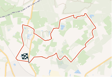
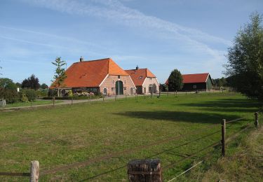
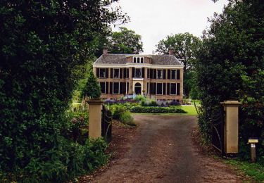
Percorso A piedi di 10 km da scoprire a Gelderland, Sconosciuto, Bronckhorst. Questo percorso è proposto da SityTrail - itinéraires balisés pédestres.
Descrizione
Trail created by Recreatieschap Achterhoek Liemers.
Sito web: http://www.recreatieschap.nl/startpunten/top_vorden.aspx
Localizzazione
Paese:
Netherlands
Regione :
Gelderland
Dipartimento/Provincia :
Sconosciuto
Comune :
Bronckhorst
Località :
Unknown
Partenza:(Dec)
Partenza:(UTM)
315933 ; 5776961 (32U) N.
Commenti
Percorsi nelle vicinanze
![Percorso A piedi Lochem - Rondje Velhorst - Photo](https://media.geolcdn.com/t/375/260/55919bbd-4040-4eb2-9b13-521e584d1f27.jpeg&format=jpg&maxdim=2)
![A piedi A piedi](https://static1.geolcdn.com/sitytour/trail-icons/100.png)
Rondje Velhorst
A piedi
Facile
Lochem,
Gelderland,
Sconosciuto,
Netherlands
![](/images/other/stat-length.png)
3,6 km | 4 km-effort
55min
![](https://static1.geolcdn.com/siteimages/upload/files/16400158638029165_repeat_loop_refresh_sync_direction_icon.png)
Sì
![Percorso A piedi Bronckhorst - Hackfortse Enkroute - Photo](https://media.geolcdn.com/t/375/260/40f9f402-e097-413d-87d3-c98c81a339fc.jpeg&format=jpg&maxdim=2)
![A piedi A piedi](https://static1.geolcdn.com/sitytour/trail-icons/100.png)
Hackfortse Enkroute
A piedi
Facile
Bronckhorst,
Gelderland,
Sconosciuto,
Netherlands
![](/images/other/stat-length.png)
16,5 km | 18 km-effort
4h 5min
![](https://static1.geolcdn.com/siteimages/upload/files/16400158638029165_repeat_loop_refresh_sync_direction_icon.png)
Sì
![Percorso A piedi Lochem - Rondje Almen - Photo](https://media.geolcdn.com/t/375/260/9448f3cc-3218-4985-8aea-1eaf9a59cd1e.jpeg&format=jpg&maxdim=2)
![A piedi A piedi](https://static1.geolcdn.com/sitytour/trail-icons/100.png)
Rondje Almen
A piedi
Facile
Lochem,
Gelderland,
Sconosciuto,
Netherlands
![](/images/other/stat-length.png)
4,6 km | 4,8 km-effort
1h 5min
![](https://static1.geolcdn.com/siteimages/upload/files/16400158638029165_repeat_loop_refresh_sync_direction_icon.png)
Sì
![Percorso A piedi Bronckhorst - De Wildenborch Route - Photo](https://media.geolcdn.com/t/375/260/03237455-549e-486d-9ec0-9a1319ae6ede.jpeg&format=jpg&maxdim=2)
![A piedi A piedi](https://static1.geolcdn.com/sitytour/trail-icons/100.png)
De Wildenborch Route
A piedi
Facile
Bronckhorst,
Gelderland,
Sconosciuto,
Netherlands
![](/images/other/stat-length.png)
6,5 km | 7 km-effort
1h 35min
![](https://static1.geolcdn.com/siteimages/upload/files/16400158638029165_repeat_loop_refresh_sync_direction_icon.png)
Sì
![Percorso A piedi Lochem - Onderlaatsche Laakroute - Photo](https://media.geolcdn.com/t/375/260/0c1a3f46-6d65-476b-aa36-984711d78f86.jpeg&format=jpg&maxdim=2)
![A piedi A piedi](https://static1.geolcdn.com/sitytour/trail-icons/100.png)
Onderlaatsche Laakroute
A piedi
Facile
Lochem,
Gelderland,
Sconosciuto,
Netherlands
![](/images/other/stat-length.png)
5,9 km | 6,5 km-effort
1h 28min
![](https://static1.geolcdn.com/siteimages/upload/files/16400158638029165_repeat_loop_refresh_sync_direction_icon.png)
Sì
![Percorso A piedi Bronckhorst - Groene Wissel Vorden - Photo](https://media.geolcdn.com/t/375/260/8a04b06c-899e-4d67-8753-414f94f77f6b.jpeg&format=jpg&maxdim=2)
![A piedi A piedi](https://static1.geolcdn.com/sitytour/trail-icons/100.png)
Groene Wissel Vorden
A piedi
Facile
Bronckhorst,
Gelderland,
Sconosciuto,
Netherlands
![](/images/other/stat-length.png)
16,5 km | 18,2 km-effort
4h 8min
![](https://static1.geolcdn.com/siteimages/upload/files/16400158638029165_repeat_loop_refresh_sync_direction_icon.png)
Sì
![Percorso A piedi Zutphen - Leestensche Broekpad (Klompenpad) - Photo](https://media.geolcdn.com/t/375/260/44e3f8db-a211-4e70-b435-60081fcd3243.jpeg&format=jpg&maxdim=2)
![A piedi A piedi](https://static1.geolcdn.com/sitytour/trail-icons/100.png)
Leestensche Broekpad (Klompenpad)
A piedi
Facile
Zutphen,
Gelderland,
Sconosciuto,
Netherlands
![](/images/other/stat-length.png)
11,7 km | 12,6 km-effort
2h 51min
![](https://static1.geolcdn.com/siteimages/upload/files/16400158638029165_repeat_loop_refresh_sync_direction_icon.png)
Sì
![Percorso A piedi Lochem - Wandelroute Velhorst - Photo](https://media.geolcdn.com/t/375/260/e9cc0aa8-ce7b-4228-a4f9-08b8b8f29085.jpeg&format=jpg&maxdim=2)
![A piedi A piedi](https://static1.geolcdn.com/sitytour/trail-icons/100.png)
Wandelroute Velhorst
A piedi
Facile
Lochem,
Gelderland,
Sconosciuto,
Netherlands
![](/images/other/stat-length.png)
17,2 km | 18,9 km-effort
4h 17min
![](https://static1.geolcdn.com/siteimages/upload/files/16400158638029165_repeat_loop_refresh_sync_direction_icon.png)
Sì
![Percorso A piedi Bronckhorst - Ockhorstroute - Photo](https://media.geolcdn.com/t/375/260/6cd8504f-9b6a-4dbb-968b-06c70e52fa7b.jpeg&format=jpg&maxdim=2)
![A piedi A piedi](https://static1.geolcdn.com/sitytour/trail-icons/100.png)
Ockhorstroute
A piedi
Facile
Bronckhorst,
Gelderland,
Sconosciuto,
Netherlands
![](/images/other/stat-length.png)
7,7 km | 8,4 km-effort
1h 54min
![](https://static1.geolcdn.com/siteimages/upload/files/16400158638029165_repeat_loop_refresh_sync_direction_icon.png)
Sì