![](/images/other/stat-length.png)
![Percorso A piedi Montfaucon - CH-Les Sarains - fixme - Photo](https://media.geolcdn.com/t/1900/400/ext.pjpeg?maxdim=2&url=https%3A%2F%2Fstatic1.geolcdn.com%2Fsiteimages%2Fupload%2Ffiles%2F1545311037marcheuse_200dpi.jpg)
CH-Les Sarains - fixme
SityTrail - itinéraires balisés pédestres
Tous les sentiers balisés d’Europe GUIDE+
![Lunghezza](/images/other/stat-length.png)
Lunghezza
3,5 km
![Altitudine massima](https://static1.geolcdn.com/siteimages/upload/files/1508320355ic_sort_altitude_max_24dp.png)
Altitudine massima
1051 m
![Dislivello positivo](https://static1.geolcdn.com/siteimages/upload/files/1508320355ic_sort_den_pos_24dp.png)
Dislivello positivo
67 m
![Km-Effort](/images/other/stat-length.png)
Km-Effort
4,6 km
![Altitudine minima](https://static1.geolcdn.com/siteimages/upload/files/1508320355ic_sort_altitude_min_24dp.png)
Altitudine minima
936 m
![Dislivello negativo](https://static1.geolcdn.com/siteimages/upload/files/1508320355ic_sort_den_neg_24dp.png)
Dislivello negativo
125 m
![Boucle](https://static1.geolcdn.com/siteimages/upload/files/16400158638029165_repeat_loop_refresh_sync_direction_icon.png)
Boucle
No
Data di creazione :
2022-02-14 08:55:49.493
Ultima modifica :
2022-02-14 08:55:49.493
![A piedi](https://static1.geolcdn.com/sitytour/trail-icons/100.png)
1h03
Difficoltà : Facile
![Scannerizza questo codice QR per aprire il percorso nell'applicazione SityTrail](https://capi.geolives.com/qq0zvz2zws4bq2lad0pu/sitytour/trails/3106792/qr.png?size=200)
Applicazione GPS da escursionismo GRATUITA
Chi siamo
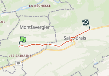
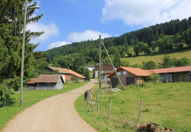
Percorso A piedi di 3,5 km da scoprire a Giura, District des Franches-Montagnes, Montfaucon. Questo percorso è proposto da SityTrail - itinéraires balisés pédestres.
Descrizione
Les Sarains - fixme
Symbol: gelbe Raute
Localizzazione
Paese:
Switzerland
Regione :
Giura
Dipartimento/Provincia :
District des Franches-Montagnes
Comune :
Montfaucon
Località :
Unknown
Partenza:(Dec)
Partenza:(UTM)
354923 ; 5240511 (32T) N.
Commenti
Percorsi nelle vicinanze
![Percorso A piedi Montfaucon - Pré Petitjean - - Photo](https://media.geolcdn.com/t/375/260/d3e4699c-161c-4bf6-8b9d-6e6635dcf90a.jpeg&format=jpg&maxdim=2)
![A piedi A piedi](https://static1.geolcdn.com/sitytour/trail-icons/100.png)
Pré Petitjean -
A piedi
Facile
Montfaucon,
Giura,
District des Franches-Montagnes,
Switzerland
![](/images/other/stat-length.png)
4,2 km | 5,4 km-effort
1h 13min
![](https://static1.geolcdn.com/siteimages/upload/files/16400158638029165_repeat_loop_refresh_sync_direction_icon.png)
No
![Percorso A piedi Clos du Doubs - Passerelle de La Charbonniere - Soubey - Photo](https://media.geolcdn.com/t/375/260/827ab20e-fac6-4ddc-a128-657f5a8fe4c8.jpeg&format=jpg&maxdim=2)
![A piedi A piedi](https://static1.geolcdn.com/sitytour/trail-icons/100.png)
Passerelle de La Charbonniere - Soubey
A piedi
Facile
Clos du Doubs,
Giura,
District de Porrentruy,
Switzerland
![](/images/other/stat-length.png)
5 km | 6,2 km-effort
1h 24min
![](https://static1.geolcdn.com/siteimages/upload/files/16400158638029165_repeat_loop_refresh_sync_direction_icon.png)
No
![Percorso A piedi Saint-Brais - Le Poye - fixme - Photo](https://media.geolcdn.com/t/375/260/091e7155-675e-45d4-8da6-1d843ef54918.jpeg&format=jpg&maxdim=2)
![A piedi A piedi](https://static1.geolcdn.com/sitytour/trail-icons/100.png)
Le Poye - fixme
A piedi
Facile
Saint-Brais,
Giura,
District des Franches-Montagnes,
Switzerland
![](/images/other/stat-length.png)
3,7 km | 5,5 km-effort
1h 15min
![](https://static1.geolcdn.com/siteimages/upload/files/16400158638029165_repeat_loop_refresh_sync_direction_icon.png)
No
![Percorso A piedi Montfaucon - Le Poye - fixme - Photo](https://media.geolcdn.com/t/375/260/39ac1a07-c510-467c-860e-aa6389e033ff.jpeg&format=jpg&maxdim=2)
![A piedi A piedi](https://static1.geolcdn.com/sitytour/trail-icons/100.png)
Le Poye - fixme
A piedi
Facile
Montfaucon,
Giura,
District des Franches-Montagnes,
Switzerland
![](/images/other/stat-length.png)
3,2 km | 4,6 km-effort
1h 3min
![](https://static1.geolcdn.com/siteimages/upload/files/16400158638029165_repeat_loop_refresh_sync_direction_icon.png)
No
![Percorso A piedi Saint-Brais - Tariche - Pont de Ravines - Photo](https://media.geolcdn.com/t/375/260/976f4996-25f5-4d97-aa6d-b26d356687f2.jpeg&format=jpg&maxdim=2)
![A piedi A piedi](https://static1.geolcdn.com/sitytour/trail-icons/100.png)
Tariche - Pont de Ravines
A piedi
Facile
Saint-Brais,
Giura,
District des Franches-Montagnes,
Switzerland
![](/images/other/stat-length.png)
4,1 km | 5 km-effort
1h 7min
![](https://static1.geolcdn.com/siteimages/upload/files/16400158638029165_repeat_loop_refresh_sync_direction_icon.png)
No
![Percorso A piedi Saint-Brais - Tariche - Le Poye - Photo](https://media.geolcdn.com/t/375/260/976f4996-25f5-4d97-aa6d-b26d356687f2.jpeg&format=jpg&maxdim=2)
![A piedi A piedi](https://static1.geolcdn.com/sitytour/trail-icons/100.png)
Tariche - Le Poye
A piedi
Facile
Saint-Brais,
Giura,
District des Franches-Montagnes,
Switzerland
![](/images/other/stat-length.png)
3,4 km | 4,8 km-effort
1h 5min
![](https://static1.geolcdn.com/siteimages/upload/files/16400158638029165_repeat_loop_refresh_sync_direction_icon.png)
No
![Percorso A piedi Soubey - Soubey - Les Enfers - Photo](https://media.geolcdn.com/t/375/260/827ab20e-fac6-4ddc-a128-657f5a8fe4c8.jpeg&format=jpg&maxdim=2)
![A piedi A piedi](https://static1.geolcdn.com/sitytour/trail-icons/100.png)
Soubey - Les Enfers
A piedi
Facile
Soubey,
Giura,
District des Franches-Montagnes,
Switzerland
![](/images/other/stat-length.png)
3,5 km | 8,2 km-effort
1h 52min
![](https://static1.geolcdn.com/siteimages/upload/files/16400158638029165_repeat_loop_refresh_sync_direction_icon.png)
No
![Percorso A piedi Soubey - Soubey - Moulin Jeannottat - Photo](https://media.geolcdn.com/t/375/260/827ab20e-fac6-4ddc-a128-657f5a8fe4c8.jpeg&format=jpg&maxdim=2)
![A piedi A piedi](https://static1.geolcdn.com/sitytour/trail-icons/100.png)
Soubey - Moulin Jeannottat
A piedi
Facile
Soubey,
Giura,
District des Franches-Montagnes,
Switzerland
![](/images/other/stat-length.png)
5,1 km | 7,6 km-effort
1h 43min
![](https://static1.geolcdn.com/siteimages/upload/files/16400158638029165_repeat_loop_refresh_sync_direction_icon.png)
No
![Percorso A piedi Montfaucon - Montfaucon - Le Bémont - Photo](https://media.geolcdn.com/t/375/260/ext.jpg?maxdim=2&url=https%3A%2F%2Fstatic1.geolcdn.com%2Fsiteimages%2Fupload%2Ffiles%2F1545311037marcheuse_200dpi.jpg)
![A piedi A piedi](https://static1.geolcdn.com/sitytour/trail-icons/100.png)
Montfaucon - Le Bémont
A piedi
Facile
Montfaucon,
Giura,
District des Franches-Montagnes,
Switzerland
![](/images/other/stat-length.png)
3,6 km | 4,2 km-effort
56min
![](https://static1.geolcdn.com/siteimages/upload/files/16400158638029165_repeat_loop_refresh_sync_direction_icon.png)
No