![](/images/other/stat-length.png)
![Percorso A piedi Rheinau - Brücke Rheinau - Strick - Photo](https://media.geolcdn.com/t/1900/400/edfdb82e-b4c7-4ec1-803b-fc0a6334a895.jpeg&format=pjpeg&maxdim=2)
Brücke Rheinau - Strick
SityTrail - itinéraires balisés pédestres
Tous les sentiers balisés d’Europe GUIDE+
![Lunghezza](/images/other/stat-length.png)
Lunghezza
3,8 km
![Altitudine massima](https://static1.geolcdn.com/siteimages/upload/files/1508320355ic_sort_altitude_max_24dp.png)
Altitudine massima
389 m
![Dislivello positivo](https://static1.geolcdn.com/siteimages/upload/files/1508320355ic_sort_den_pos_24dp.png)
Dislivello positivo
50 m
![Km-Effort](/images/other/stat-length.png)
Km-Effort
4,5 km
![Altitudine minima](https://static1.geolcdn.com/siteimages/upload/files/1508320355ic_sort_altitude_min_24dp.png)
Altitudine minima
350 m
![Dislivello negativo](https://static1.geolcdn.com/siteimages/upload/files/1508320355ic_sort_den_neg_24dp.png)
Dislivello negativo
61 m
![Boucle](https://static1.geolcdn.com/siteimages/upload/files/16400158638029165_repeat_loop_refresh_sync_direction_icon.png)
Boucle
No
Tag
Data di creazione :
2022-02-14 08:47:23.382
Ultima modifica :
2022-02-14 08:47:23.382
![A piedi](https://static1.geolcdn.com/sitytour/trail-icons/100.png)
1h00
Difficoltà : Facile
![Scannerizza questo codice QR per aprire il percorso nell'applicazione SityTrail](https://capi.geolives.com/qq0zvz2zws4bq2lad0pu/sitytour/trails/3106068/qr.png?size=200)
Applicazione GPS da escursionismo GRATUITA
Chi siamo
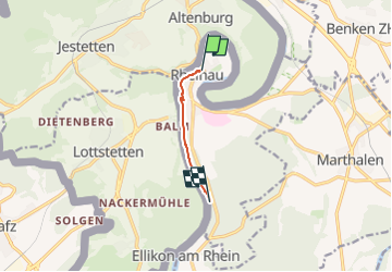
Percorso A piedi di 3,8 km da scoprire a Zurigo, Bezirk Andelfingen, Rheinau. Questo percorso è proposto da SityTrail - itinéraires balisés pédestres.
Descrizione
Brücke Rheinau - Strick
Symbol: gelber Diamant (waagrecht)
Localizzazione
Paese:
Switzerland
Regione :
Zurigo
Dipartimento/Provincia :
Bezirk Andelfingen
Comune :
Rheinau
Località :
Unknown
Partenza:(Dec)
Partenza:(UTM)
470200 ; 5276904 (32T) N.
Commenti
Percorsi nelle vicinanze
![Percorso A piedi Rafz - Rafz - Eglisau Bahnhof - Photo](https://media.geolcdn.com/t/375/260/db32595a-b7f7-4371-b947-c2ac8504042d.jpeg&format=jpg&maxdim=2)
![A piedi A piedi](https://static1.geolcdn.com/sitytour/trail-icons/100.png)
Rafz - Eglisau Bahnhof
A piedi
Facile
Rafz,
Zurigo,
Bezirk Bülach,
Switzerland
![](/images/other/stat-length.png)
5,4 km | 6,3 km-effort
1h 26min
![](https://static1.geolcdn.com/siteimages/upload/files/16400158638029165_repeat_loop_refresh_sync_direction_icon.png)
No
![Percorso A piedi Rafz - Rafz - Ellikon am Rhein - Photo](https://media.geolcdn.com/t/375/260/25c4e05d-745d-4279-a6b0-ba809d7600a9.jpeg&format=jpg&maxdim=2)
![A piedi A piedi](https://static1.geolcdn.com/sitytour/trail-icons/100.png)
Rafz - Ellikon am Rhein
A piedi
Facile
Rafz,
Zurigo,
Bezirk Bülach,
Switzerland
![](/images/other/stat-length.png)
7,1 km | 9,5 km-effort
2h 9min
![](https://static1.geolcdn.com/siteimages/upload/files/16400158638029165_repeat_loop_refresh_sync_direction_icon.png)
No
![Percorso A piedi Rafz - Rafz Bahnhof - Lottstetten - Photo](https://media.geolcdn.com/t/375/260/6f369ae1-d2f7-4e1f-be8b-70d0bbdeb91e.jpeg&format=jpg&maxdim=2)
![A piedi A piedi](https://static1.geolcdn.com/sitytour/trail-icons/100.png)
Rafz Bahnhof - Lottstetten
A piedi
Facile
Rafz,
Zurigo,
Bezirk Bülach,
Switzerland
![](/images/other/stat-length.png)
5,4 km | 7,3 km-effort
1h 39min
![](https://static1.geolcdn.com/siteimages/upload/files/16400158638029165_repeat_loop_refresh_sync_direction_icon.png)
No
![Percorso A piedi Rafz - Rafz Bahnhof - Nack - Photo](https://media.geolcdn.com/t/375/260/052bc02c-b012-4124-9cd6-58dc89d28dd1.jpeg&format=jpg&maxdim=2)
![A piedi A piedi](https://static1.geolcdn.com/sitytour/trail-icons/100.png)
Rafz Bahnhof - Nack
A piedi
Facile
Rafz,
Zurigo,
Bezirk Bülach,
Switzerland
![](/images/other/stat-length.png)
5,4 km | 7,5 km-effort
1h 42min
![](https://static1.geolcdn.com/siteimages/upload/files/16400158638029165_repeat_loop_refresh_sync_direction_icon.png)
No
![Percorso A piedi Lottstetten - Ziegelhütte - Fähre Ellikon am Rhein (Hochwasser Alternativroute) - Photo](https://media.geolcdn.com/t/375/260/daccca04-78af-4d11-ac2d-cc1fe3034220.jpeg&format=jpg&maxdim=2)
![A piedi A piedi](https://static1.geolcdn.com/sitytour/trail-icons/100.png)
Ziegelhütte - Fähre Ellikon am Rhein (Hochwasser Alternativroute)
A piedi
Facile
Lottstetten,
Baden-Württemberg,
Landkreis Waldshut,
Germany
![](/images/other/stat-length.png)
5 km | 5,7 km-effort
1h 17min
![](https://static1.geolcdn.com/siteimages/upload/files/16400158638029165_repeat_loop_refresh_sync_direction_icon.png)
No
![Percorso A piedi Laufen-Uhwiesen - Nohlbrücke - Wehrbrücke Rheinau - Photo](https://media.geolcdn.com/t/375/260/cff12f90-adb2-4075-82f2-1fb0bf9a06a8.jpeg&format=jpg&maxdim=2)
![A piedi A piedi](https://static1.geolcdn.com/sitytour/trail-icons/100.png)
Nohlbrücke - Wehrbrücke Rheinau
A piedi
Facile
Laufen-Uhwiesen,
Zurigo,
Bezirk Andelfingen,
Switzerland
![](/images/other/stat-length.png)
5,6 km | 6,5 km-effort
1h 27min
![](https://static1.geolcdn.com/siteimages/upload/files/16400158638029165_repeat_loop_refresh_sync_direction_icon.png)
No
![Percorso A piedi Rheinau - Brücke Rheinau - Strick - Photo](https://media.geolcdn.com/t/375/260/edfdb82e-b4c7-4ec1-803b-fc0a6334a895.jpeg&format=jpg&maxdim=2)
![A piedi A piedi](https://static1.geolcdn.com/sitytour/trail-icons/100.png)
Brücke Rheinau - Strick
A piedi
Facile
Rheinau,
Zurigo,
Bezirk Andelfingen,
Switzerland
![](/images/other/stat-length.png)
3,8 km | 4,5 km-effort
1h 1min
![](https://static1.geolcdn.com/siteimages/upload/files/16400158638029165_repeat_loop_refresh_sync_direction_icon.png)
No
![Percorso A piedi Rafz - Rafz - Wil - Photo](https://media.geolcdn.com/t/375/260/04242084-88ad-45e0-846a-5689a0216b40.jpeg&format=jpg&maxdim=2)
![A piedi A piedi](https://static1.geolcdn.com/sitytour/trail-icons/100.png)
![Percorso A piedi Dachsen - Mettli - EW Rheinau Wehrbrücke - Photo](https://media.geolcdn.com/t/375/260/e97a8f87-552d-4714-93de-b473f5c84261.jpeg&format=jpg&maxdim=2)
![A piedi A piedi](https://static1.geolcdn.com/sitytour/trail-icons/100.png)
Mettli - EW Rheinau Wehrbrücke
A piedi
Facile
Dachsen,
Zurigo,
Bezirk Andelfingen,
Switzerland
![](/images/other/stat-length.png)
3,8 km | 4,6 km-effort
1h 2min
![](https://static1.geolcdn.com/siteimages/upload/files/16400158638029165_repeat_loop_refresh_sync_direction_icon.png)
No