![](/images/other/stat-length.png)
![Percorso A piedi Rimsting - Chiemsee Rundweg - Photo](https://media.geolcdn.com/t/1900/400/ext.pjpeg?maxdim=2&url=https%3A%2F%2Fmedia.geolcdn.com%2Ff%2Fa3783cef-8491-4f1d-8527-28c3198aef67.jpeg)
Chiemsee Rundweg
SityTrail - itinéraires balisés pédestres
Tous les sentiers balisés d’Europe PRO
![Lunghezza](/images/other/stat-length.png)
Lunghezza
58 km
![Altitudine massima](https://static1.geolcdn.com/siteimages/upload/files/1508320355ic_sort_altitude_max_24dp.png)
Altitudine massima
599 m
![Dislivello positivo](https://static1.geolcdn.com/siteimages/upload/files/1508320355ic_sort_den_pos_24dp.png)
Dislivello positivo
570 m
![Km-Effort](/images/other/stat-length.png)
Km-Effort
66 km
![Altitudine minima](https://static1.geolcdn.com/siteimages/upload/files/1508320355ic_sort_altitude_min_24dp.png)
Altitudine minima
514 m
![Dislivello negativo](https://static1.geolcdn.com/siteimages/upload/files/1508320355ic_sort_den_neg_24dp.png)
Dislivello negativo
577 m
![Boucle](https://static1.geolcdn.com/siteimages/upload/files/16400158638029165_repeat_loop_refresh_sync_direction_icon.png)
Boucle
Sì
Tag
Data di creazione :
2022-02-11 19:23:24.163
Ultima modifica :
2022-02-11 19:23:24.163
![A piedi](https://static1.geolcdn.com/sitytour/trail-icons/100.png)
14h57
Difficoltà : Molto difficile
![Scannerizza questo codice QR per aprire il percorso nell'applicazione SityTrail](https://capi.geolives.com/qq0zvz2zws4bq2lad0pu/sitytour/trails/3100618/qr.png?size=200)
Applicazione GPS da escursionismo GRATUITA
Chi siamo
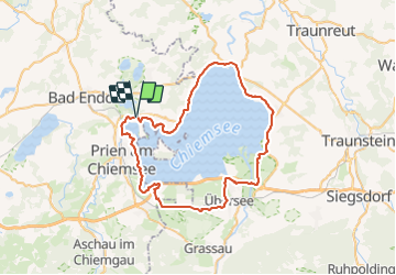
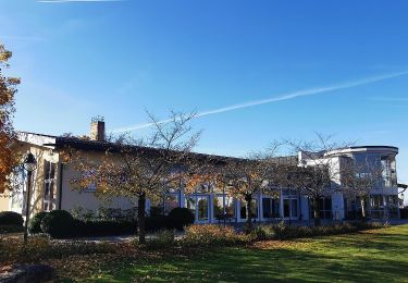
Percorso A piedi di 58 km da scoprire a Baviera, Landkreis Rosenheim, Rimsting. Questo percorso è proposto da SityTrail - itinéraires balisés pédestres.
Descrizione
Kopie des Radwegs "Chiemsee Rundweg"
Symbol: Runde Schilder mit Chiemsee im Hintergrund, grünem Rahmen und Abbildung eines Fußgängers und Radfahrers
Localizzazione
Paese:
Germany
Regione :
Baviera
Dipartimento/Provincia :
Landkreis Rosenheim
Comune :
Rimsting
Località :
Unknown
Partenza:(Dec)
Partenza:(UTM)
303048 ; 5307381 (33T) N.
Commenti
Percorsi nelle vicinanze
![Percorso A piedi Prien am Chiemsee - Rundweg 1 - Photo](https://media.geolcdn.com/t/375/260/ext.jpg?maxdim=2&url=https%3A%2F%2Fmedia.geolcdn.com%2Ff%2F3a34bc52-9a86-4da3-b0da-5309ee43fba5.jpeg)
![A piedi A piedi](https://static1.geolcdn.com/sitytour/trail-icons/100.png)
Rundweg 1
A piedi
Facile
Prien am Chiemsee,
Baviera,
Landkreis Rosenheim,
Germany
![](/images/other/stat-length.png)
3,9 km | 5,4 km-effort
1h 13min
![](https://static1.geolcdn.com/siteimages/upload/files/16400158638029165_repeat_loop_refresh_sync_direction_icon.png)
Sì
![Percorso A piedi Chiemsee - Rundweg - Tour 1 - Photo](https://media.geolcdn.com/t/375/260/ext.jpg?maxdim=2&url=https%3A%2F%2Fmedia.geolcdn.com%2Ff%2Fddfa5a3a-103c-4358-a1be-47d68e697cb0.jpeg)
![A piedi A piedi](https://static1.geolcdn.com/sitytour/trail-icons/100.png)
Rundweg - Tour 1
A piedi
Facile
Chiemsee,
Baviera,
Landkreis Rosenheim,
Germany
![](/images/other/stat-length.png)
4 km | 4,6 km-effort
1h 3min
![](https://static1.geolcdn.com/siteimages/upload/files/16400158638029165_repeat_loop_refresh_sync_direction_icon.png)
Sì
![Percorso A piedi Chiemsee - Rundweg - Tour 2 - Photo](https://media.geolcdn.com/t/375/260/ext.jpg?maxdim=2&url=https%3A%2F%2Fmedia.geolcdn.com%2Ff%2Fc589e373-20ec-4a86-9891-32bd0698d01a.jpeg)
![A piedi A piedi](https://static1.geolcdn.com/sitytour/trail-icons/100.png)
Rundweg - Tour 2
A piedi
Facile
Chiemsee,
Baviera,
Landkreis Rosenheim,
Germany
![](/images/other/stat-length.png)
4,7 km | 5,6 km-effort
1h 15min
![](https://static1.geolcdn.com/siteimages/upload/files/16400158638029165_repeat_loop_refresh_sync_direction_icon.png)
Sì
![Percorso A piedi Bad Endorf - Wanderweg 5 - Bad Endorf - Photo](https://media.geolcdn.com/t/375/260/ext.jpg?maxdim=2&url=https%3A%2F%2Fmedia.geolcdn.com%2Ff%2F3de04759-bc4f-4e48-9110-323c1773c99c.jpeg)
![A piedi A piedi](https://static1.geolcdn.com/sitytour/trail-icons/100.png)
Wanderweg 5 - Bad Endorf
A piedi
Facile
Bad Endorf,
Baviera,
Landkreis Rosenheim,
Germany
![](/images/other/stat-length.png)
3,8 km | 4,7 km-effort
1h 4min
![](https://static1.geolcdn.com/siteimages/upload/files/16400158638029165_repeat_loop_refresh_sync_direction_icon.png)
No
![Percorso A piedi Bad Endorf - Wanderweg 9 - Bad Endorf - Photo](https://media.geolcdn.com/t/375/260/ext.jpg?maxdim=2&url=https%3A%2F%2Fmedia.geolcdn.com%2Ff%2F3de04759-bc4f-4e48-9110-323c1773c99c.jpeg)
![A piedi A piedi](https://static1.geolcdn.com/sitytour/trail-icons/100.png)
Wanderweg 9 - Bad Endorf
A piedi
Facile
Bad Endorf,
Baviera,
Landkreis Rosenheim,
Germany
![](/images/other/stat-length.png)
7,9 km | 9,4 km-effort
2h 8min
![](https://static1.geolcdn.com/siteimages/upload/files/16400158638029165_repeat_loop_refresh_sync_direction_icon.png)
Sì
![Percorso A piedi Bad Endorf - Wanderweg 7 - Bad Endorf - Stockhamer Rundweg - Photo](https://media.geolcdn.com/t/375/260/ext.jpg?maxdim=2&url=https%3A%2F%2Fmedia.geolcdn.com%2Ff%2F3de04759-bc4f-4e48-9110-323c1773c99c.jpeg)
![A piedi A piedi](https://static1.geolcdn.com/sitytour/trail-icons/100.png)
Wanderweg 7 - Bad Endorf - Stockhamer Rundweg
A piedi
Facile
Bad Endorf,
Baviera,
Landkreis Rosenheim,
Germany
![](/images/other/stat-length.png)
6 km | 7,2 km-effort
1h 38min
![](https://static1.geolcdn.com/siteimages/upload/files/16400158638029165_repeat_loop_refresh_sync_direction_icon.png)
Sì
![Percorso A piedi Bad Endorf - Wanderweg 4 - Bad Endorf - Photo](https://media.geolcdn.com/t/375/260/ext.jpg?maxdim=2&url=https%3A%2F%2Fmedia.geolcdn.com%2Ff%2Fd4576c82-5f44-4a90-b157-f67182de83b4.jpeg)
![A piedi A piedi](https://static1.geolcdn.com/sitytour/trail-icons/100.png)
Wanderweg 4 - Bad Endorf
A piedi
Facile
Bad Endorf,
Baviera,
Landkreis Rosenheim,
Germany
![](/images/other/stat-length.png)
6,1 km | 7,7 km-effort
1h 44min
![](https://static1.geolcdn.com/siteimages/upload/files/16400158638029165_repeat_loop_refresh_sync_direction_icon.png)
Sì
![Percorso A piedi Bad Endorf - Wanderweg 3 - Bad Endorf - Photo](https://media.geolcdn.com/t/375/260/ext.jpg?maxdim=2&url=https%3A%2F%2Fmedia.geolcdn.com%2Ff%2Ffbe6b374-0a82-4441-adce-5301e49d18a5.jpeg)
![A piedi A piedi](https://static1.geolcdn.com/sitytour/trail-icons/100.png)
Wanderweg 3 - Bad Endorf
A piedi
Facile
Bad Endorf,
Baviera,
Landkreis Rosenheim,
Germany
![](/images/other/stat-length.png)
4,5 km | 5,7 km-effort
1h 17min
![](https://static1.geolcdn.com/siteimages/upload/files/16400158638029165_repeat_loop_refresh_sync_direction_icon.png)
Sì
![Percorso A piedi Bad Endorf - Wanderweg 16 - Bad Endorf - Photo](https://media.geolcdn.com/t/375/260/ext.jpg?maxdim=2&url=https%3A%2F%2Fmedia.geolcdn.com%2Ff%2Fd4576c82-5f44-4a90-b157-f67182de83b4.jpeg)
![A piedi A piedi](https://static1.geolcdn.com/sitytour/trail-icons/100.png)
Wanderweg 16 - Bad Endorf
A piedi
Facile
Bad Endorf,
Baviera,
Landkreis Rosenheim,
Germany
![](/images/other/stat-length.png)
5,3 km | 6,5 km-effort
1h 28min
![](https://static1.geolcdn.com/siteimages/upload/files/16400158638029165_repeat_loop_refresh_sync_direction_icon.png)
No