![](/images/other/stat-length.png)
![Percorso A piedi Niederkrüchten - Elmpterwald Grenzgeschichten - Photo](https://media.geolcdn.com/t/1900/400/ext.pjpeg?maxdim=2&url=https%3A%2F%2Fmedia.geolcdn.com%2Ff%2F8e14d6fd-9613-4986-a202-609e7f4050ef.jpeg)
Elmpterwald Grenzgeschichten
SityTrail - itinéraires balisés pédestres
Tous les sentiers balisés d’Europe PRO
![Lunghezza](/images/other/stat-length.png)
Lunghezza
4,6 km
![Altitudine massima](https://static1.geolcdn.com/siteimages/upload/files/1508320355ic_sort_altitude_max_24dp.png)
Altitudine massima
68 m
![Dislivello positivo](https://static1.geolcdn.com/siteimages/upload/files/1508320355ic_sort_den_pos_24dp.png)
Dislivello positivo
63 m
![Km-Effort](/images/other/stat-length.png)
Km-Effort
5,4 km
![Altitudine minima](https://static1.geolcdn.com/siteimages/upload/files/1508320355ic_sort_altitude_min_24dp.png)
Altitudine minima
32 m
![Dislivello negativo](https://static1.geolcdn.com/siteimages/upload/files/1508320355ic_sort_den_neg_24dp.png)
Dislivello negativo
41 m
![Boucle](https://static1.geolcdn.com/siteimages/upload/files/16400158638029165_repeat_loop_refresh_sync_direction_icon.png)
Boucle
No
Tag
Data di creazione :
2022-02-11 19:06:10.064
Ultima modifica :
2022-02-11 19:06:10.064
![A piedi](https://static1.geolcdn.com/sitytour/trail-icons/100.png)
1h13
Difficoltà : Facile
![Scannerizza questo codice QR per aprire il percorso nell'applicazione SityTrail](https://capi.geolives.com/qq0zvz2zws4bq2lad0pu/sitytour/trails/3100256/qr.png?size=200)
Applicazione GPS da escursionismo GRATUITA
Chi siamo
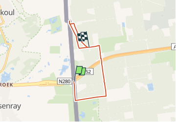
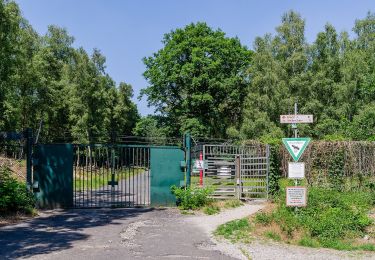
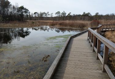
Percorso A piedi di 4,6 km da scoprire a Renania Settentrionale-Vestfalia, Kreis Viersen, Niederkrüchten. Questo percorso è proposto da SityTrail - itinéraires balisés pédestres.
Descrizione
Symbol: Weißer Pfeil auf braunen Quadrat
Localizzazione
Paese:
Germany
Regione :
Renania Settentrionale-Vestfalia
Dipartimento/Provincia :
Kreis Viersen
Comune :
Niederkrüchten
Località :
Unknown
Partenza:(Dec)
Partenza:(UTM)
295391 ; 5676132 (32U) N.
Commenti
Percorsi nelle vicinanze
![Percorso A piedi Niederkrüchten - Rundweg A12 Grenzwald - Photo](https://media.geolcdn.com/t/375/260/ext.jpg?maxdim=2&url=https%3A%2F%2Fmedia.geolcdn.com%2Ff%2Fd86b75dd-95c2-4b3f-b833-706a4cf4ba8d.jpeg)
![A piedi A piedi](https://static1.geolcdn.com/sitytour/trail-icons/100.png)
Rundweg A12 Grenzwald
A piedi
Medio
Niederkrüchten,
Renania Settentrionale-Vestfalia,
Kreis Viersen,
Germany
![](/images/other/stat-length.png)
25 km | 28 km-effort
6h 23min
![](https://static1.geolcdn.com/siteimages/upload/files/16400158638029165_repeat_loop_refresh_sync_direction_icon.png)
Sì
![Percorso A piedi Niederkrüchten - Rundweg A5 Elmpter Bruch - Photo](https://media.geolcdn.com/t/375/260/ext.jpg?maxdim=2&url=https%3A%2F%2Fmedia.geolcdn.com%2Ff%2F9628a06c-b0fa-49d7-a29e-92d1d1b8998a.jpeg)
![A piedi A piedi](https://static1.geolcdn.com/sitytour/trail-icons/100.png)
Rundweg A5 Elmpter Bruch
A piedi
Facile
Niederkrüchten,
Renania Settentrionale-Vestfalia,
Kreis Viersen,
Germany
![](/images/other/stat-length.png)
5,2 km | 6 km-effort
1h 21min
![](https://static1.geolcdn.com/siteimages/upload/files/16400158638029165_repeat_loop_refresh_sync_direction_icon.png)
Sì
![Percorso A piedi Niederkrüchten - Rundweg A4 Venekotensee - Photo](https://media.geolcdn.com/t/375/260/ext.jpg?maxdim=2&url=https%3A%2F%2Fmedia.geolcdn.com%2Ff%2Ff6e54f0a-1b74-4f37-96ed-eefad164534e.jpeg)
![A piedi A piedi](https://static1.geolcdn.com/sitytour/trail-icons/100.png)
Rundweg A4 Venekotensee
A piedi
Facile
Niederkrüchten,
Renania Settentrionale-Vestfalia,
Kreis Viersen,
Germany
![](/images/other/stat-length.png)
4,7 km | 5,3 km-effort
1h 12min
![](https://static1.geolcdn.com/siteimages/upload/files/16400158638029165_repeat_loop_refresh_sync_direction_icon.png)
Sì
![Percorso A piedi Roerdalen - Meinvennen - Photo](https://media.geolcdn.com/t/375/260/ext.jpg?maxdim=2&url=https%3A%2F%2Fmedia.geolcdn.com%2Ff%2Fdev_67061552-b6d4-4c65-8168-a2737beb5331.jpeg)
![A piedi A piedi](https://static1.geolcdn.com/sitytour/trail-icons/100.png)
Meinvennen
A piedi
Facile
Roerdalen,
Limburg,
Sconosciuto,
Netherlands
![](/images/other/stat-length.png)
17,4 km | 19,8 km-effort
4h 29min
![](https://static1.geolcdn.com/siteimages/upload/files/16400158638029165_repeat_loop_refresh_sync_direction_icon.png)
Sì
![Percorso A piedi Roermond - Schwalmbruch W1 - Photo](https://media.geolcdn.com/t/375/260/ext.jpg?maxdim=2&url=https%3A%2F%2Fmedia.geolcdn.com%2Ff%2F9628a06c-b0fa-49d7-a29e-92d1d1b8998a.jpeg)
![A piedi A piedi](https://static1.geolcdn.com/sitytour/trail-icons/100.png)
Schwalmbruch W1
A piedi
Facile
Roermond,
Limburg,
Sconosciuto,
Netherlands
![](/images/other/stat-length.png)
14,9 km | 16,6 km-effort
3h 46min
![](https://static1.geolcdn.com/siteimages/upload/files/16400158638029165_repeat_loop_refresh_sync_direction_icon.png)
Sì
![Percorso A piedi Brüggen - NSG Brachter Wald Wanderweg Weiß - Photo](https://media.geolcdn.com/t/375/260/ext.jpg?maxdim=2&url=https%3A%2F%2Fmedia.geolcdn.com%2Ff%2Fa6368e0a-31b4-4a02-933f-455dce497f22.jpeg)
![A piedi A piedi](https://static1.geolcdn.com/sitytour/trail-icons/100.png)
NSG Brachter Wald Wanderweg Weiß
A piedi
Facile
Brüggen,
Renania Settentrionale-Vestfalia,
Kreis Viersen,
Germany
![](/images/other/stat-length.png)
4,6 km | 5 km-effort
1h 8min
![](https://static1.geolcdn.com/siteimages/upload/files/16400158638029165_repeat_loop_refresh_sync_direction_icon.png)
No
![Percorso A piedi Brüggen - NSG Brachter Wald Wanderweg Grün - Photo](https://media.geolcdn.com/t/375/260/ext.jpg?maxdim=2&url=https%3A%2F%2Fmedia.geolcdn.com%2Ff%2Fa6368e0a-31b4-4a02-933f-455dce497f22.jpeg)
![A piedi A piedi](https://static1.geolcdn.com/sitytour/trail-icons/100.png)
NSG Brachter Wald Wanderweg Grün
A piedi
Facile
Brüggen,
Renania Settentrionale-Vestfalia,
Kreis Viersen,
Germany
![](/images/other/stat-length.png)
4,1 km | 4,6 km-effort
1h 2min
![](https://static1.geolcdn.com/siteimages/upload/files/16400158638029165_repeat_loop_refresh_sync_direction_icon.png)
No
![Percorso A piedi Niederkrüchten - Elmpter Schwalmbruch Rundwanderweg Rot - Photo](https://media.geolcdn.com/t/375/260/ext.jpg?maxdim=2&url=https%3A%2F%2Fmedia.geolcdn.com%2Ff%2Ff6e54f0a-1b74-4f37-96ed-eefad164534e.jpeg)
![A piedi A piedi](https://static1.geolcdn.com/sitytour/trail-icons/100.png)
Elmpter Schwalmbruch Rundwanderweg Rot
A piedi
Facile
Niederkrüchten,
Renania Settentrionale-Vestfalia,
Kreis Viersen,
Germany
![](/images/other/stat-length.png)
4,3 km | 4,9 km-effort
1h 7min
![](https://static1.geolcdn.com/siteimages/upload/files/16400158638029165_repeat_loop_refresh_sync_direction_icon.png)
Sì
![Percorso A piedi Niederkrüchten - Elmpter Schwalmbruch Rundwanderweg Blau - Photo](https://media.geolcdn.com/t/375/260/ext.jpg?maxdim=2&url=https%3A%2F%2Fmedia.geolcdn.com%2Ff%2F3f5d1254-931e-4a69-812d-066e556ce1d8.jpeg)
![A piedi A piedi](https://static1.geolcdn.com/sitytour/trail-icons/100.png)
Elmpter Schwalmbruch Rundwanderweg Blau
A piedi
Facile
Niederkrüchten,
Renania Settentrionale-Vestfalia,
Kreis Viersen,
Germany
![](/images/other/stat-length.png)
3,2 km | 3,6 km-effort
49min
![](https://static1.geolcdn.com/siteimages/upload/files/16400158638029165_repeat_loop_refresh_sync_direction_icon.png)
Sì