![](/images/other/stat-length.png)
![Percorso A piedi Duingen - DU 6 Töpferweg - Photo](https://media.geolcdn.com/t/1900/400/cb250ec2-9c29-44e9-94fa-f5ab9d279f44.jpeg&format=pjpeg&maxdim=2)
DU 6 Töpferweg
SityTrail - itinéraires balisés pédestres
Tous les sentiers balisés d’Europe GUIDE+
![Lunghezza](/images/other/stat-length.png)
Lunghezza
10,8 km
![Altitudine massima](https://static1.geolcdn.com/siteimages/upload/files/1508320355ic_sort_altitude_max_24dp.png)
Altitudine massima
305 m
![Dislivello positivo](https://static1.geolcdn.com/siteimages/upload/files/1508320355ic_sort_den_pos_24dp.png)
Dislivello positivo
192 m
![Km-Effort](/images/other/stat-length.png)
Km-Effort
13,3 km
![Altitudine minima](https://static1.geolcdn.com/siteimages/upload/files/1508320355ic_sort_altitude_min_24dp.png)
Altitudine minima
171 m
![Dislivello negativo](https://static1.geolcdn.com/siteimages/upload/files/1508320355ic_sort_den_neg_24dp.png)
Dislivello negativo
186 m
![Boucle](https://static1.geolcdn.com/siteimages/upload/files/16400158638029165_repeat_loop_refresh_sync_direction_icon.png)
Boucle
Sì
Tag
Data di creazione :
2022-02-11 18:34:16.168
Ultima modifica :
2022-02-11 18:34:16.168
![A piedi](https://static1.geolcdn.com/sitytour/trail-icons/100.png)
3h01
Difficoltà : Facile
![Scannerizza questo codice QR per aprire il percorso nell'applicazione SityTrail](https://capi.geolives.com/qq0zvz2zws4bq2lad0pu/sitytour/trails/3099642/qr.png?size=200)
Applicazione GPS da escursionismo GRATUITA
Chi siamo
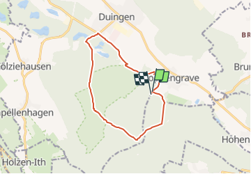
Percorso A piedi di 10,8 km da scoprire a Niedersachsen, Landkreis Hildesheim, Duingen. Questo percorso è proposto da SityTrail - itinéraires balisés pédestres.
Descrizione
Trail created by Samtgemeinde Duingen.
Sito web: https://waldhotel-humboldt.de/cms/wp-content/uploads/2013/03/Flyer_Waldhotel_wandern.pdf
Localizzazione
Paese:
Germany
Regione :
Niedersachsen
Dipartimento/Provincia :
Landkreis Hildesheim
Comune :
Duingen
Località :
Duingen
Partenza:(Dec)
Partenza:(UTM)
549089 ; 5759373 (32U) N.
Commenti
Percorsi nelle vicinanze
![Percorso A piedi Duingen - DU 5 Wiesenweg Fölziehausen - Photo](https://media.geolcdn.com/t/375/260/6507ac41-eb6f-43a3-8cf4-0681b462983c.jpeg&format=jpg&maxdim=2)
![A piedi A piedi](https://static1.geolcdn.com/sitytour/trail-icons/100.png)
DU 5 Wiesenweg Fölziehausen
A piedi
Facile
Duingen,
Niedersachsen,
Landkreis Hildesheim,
Germany
![](/images/other/stat-length.png)
13,9 km | 16,9 km-effort
3h 50min
![](https://static1.geolcdn.com/siteimages/upload/files/16400158638029165_repeat_loop_refresh_sync_direction_icon.png)
Sì
![Percorso A piedi Duingen - DU 1 Panoramaweg Pottland - Photo](https://media.geolcdn.com/t/375/260/09e7db2f-b647-4720-9d72-2bc9107dca4d.jpeg&format=jpg&maxdim=2)
![A piedi A piedi](https://static1.geolcdn.com/sitytour/trail-icons/100.png)
DU 1 Panoramaweg Pottland
A piedi
Medio
Duingen,
Niedersachsen,
Landkreis Hildesheim,
Germany
![](/images/other/stat-length.png)
18,7 km | 24 km-effort
5h 26min
![](https://static1.geolcdn.com/siteimages/upload/files/16400158638029165_repeat_loop_refresh_sync_direction_icon.png)
Sì
![Percorso A piedi Grünenplan - HZ3 Auf dem Kammweg zum Raabe-Turm - Photo](https://media.geolcdn.com/t/375/260/bb4f132c-838d-43d7-b944-3ee07de6c057.jpeg&format=jpg&maxdim=2)
![A piedi A piedi](https://static1.geolcdn.com/sitytour/trail-icons/100.png)
HZ3 Auf dem Kammweg zum Raabe-Turm
A piedi
Facile
Grünenplan,
Niedersachsen,
Landkreis Holzminden,
Germany
![](/images/other/stat-length.png)
5,9 km | 7,8 km-effort
1h 46min
![](https://static1.geolcdn.com/siteimages/upload/files/16400158638029165_repeat_loop_refresh_sync_direction_icon.png)
Sì
![Percorso A piedi Duingen - DU 4 Haidkopfweg - Photo](https://media.geolcdn.com/t/375/260/aa6515ba-5dba-4259-9e8f-5e33c1c22cee.jpeg&format=jpg&maxdim=2)
![A piedi A piedi](https://static1.geolcdn.com/sitytour/trail-icons/100.png)
DU 4 Haidkopfweg
A piedi
Facile
Duingen,
Niedersachsen,
Landkreis Hildesheim,
Germany
![](/images/other/stat-length.png)
4,6 km | 5,9 km-effort
1h 20min
![](https://static1.geolcdn.com/siteimages/upload/files/16400158638029165_repeat_loop_refresh_sync_direction_icon.png)
Sì
![Percorso A piedi Duingen - Rundweg 01 um Bruchsee bei Duingen - Photo](https://media.geolcdn.com/t/375/260/6507ac41-eb6f-43a3-8cf4-0681b462983c.jpeg&format=jpg&maxdim=2)
![A piedi A piedi](https://static1.geolcdn.com/sitytour/trail-icons/100.png)
Rundweg 01 um Bruchsee bei Duingen
A piedi
Facile
Duingen,
Niedersachsen,
Landkreis Hildesheim,
Germany
![](/images/other/stat-length.png)
3,1 km | 3,5 km-effort
47min
![](https://static1.geolcdn.com/siteimages/upload/files/16400158638029165_repeat_loop_refresh_sync_direction_icon.png)
Sì
![Percorso A piedi Duingen - Geologischer Lehrpfad Weenzerbruch - Photo](https://media.geolcdn.com/t/375/260/aa6515ba-5dba-4259-9e8f-5e33c1c22cee.jpeg&format=jpg&maxdim=2)
![A piedi A piedi](https://static1.geolcdn.com/sitytour/trail-icons/100.png)
Geologischer Lehrpfad Weenzerbruch
A piedi
Facile
Duingen,
Niedersachsen,
Landkreis Hildesheim,
Germany
![](/images/other/stat-length.png)
4,6 km | 5,9 km-effort
1h 20min
![](https://static1.geolcdn.com/siteimages/upload/files/16400158638029165_repeat_loop_refresh_sync_direction_icon.png)
Sì