![](/images/other/stat-length.png)
![Percorso A piedi Oranienbaum-Wörlitz - Förster Wöpke Weg - Photo](https://media.geolcdn.com/t/1900/400/f8beb8ab-cc36-40b3-9311-01cca62a7ad3.jpeg&format=pjpeg&maxdim=2)
Förster Wöpke Weg
SityTrail - itinéraires balisés pédestres
Tous les sentiers balisés d’Europe GUIDE+
![Lunghezza](/images/other/stat-length.png)
Lunghezza
10,6 km
![Altitudine massima](https://static1.geolcdn.com/siteimages/upload/files/1508320355ic_sort_altitude_max_24dp.png)
Altitudine massima
77 m
![Dislivello positivo](https://static1.geolcdn.com/siteimages/upload/files/1508320355ic_sort_den_pos_24dp.png)
Dislivello positivo
57 m
![Km-Effort](/images/other/stat-length.png)
Km-Effort
11,4 km
![Altitudine minima](https://static1.geolcdn.com/siteimages/upload/files/1508320355ic_sort_altitude_min_24dp.png)
Altitudine minima
57 m
![Dislivello negativo](https://static1.geolcdn.com/siteimages/upload/files/1508320355ic_sort_den_neg_24dp.png)
Dislivello negativo
69 m
![Boucle](https://static1.geolcdn.com/siteimages/upload/files/16400158638029165_repeat_loop_refresh_sync_direction_icon.png)
Boucle
No
Tag
Data di creazione :
2022-02-11 17:48:46.139
Ultima modifica :
2022-02-11 17:48:46.139
![A piedi](https://static1.geolcdn.com/sitytour/trail-icons/100.png)
2h35
Difficoltà : Facile
![Scannerizza questo codice QR per aprire il percorso nell'applicazione SityTrail](https://capi.geolives.com/qq0zvz2zws4bq2lad0pu/sitytour/trails/3098569/qr.png?size=200)
Applicazione GPS da escursionismo GRATUITA
Chi siamo
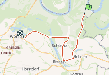
Percorso A piedi di 10,6 km da scoprire a Sachsen-Anhalt, Wittenberg, Oranienbaum-Wörlitz. Questo percorso è proposto da SityTrail - itinéraires balisés pédestres.
Descrizione
Trail created by Wörlitz-Information.
auch als Radroute
Localizzazione
Paese:
Germany
Regione :
Sachsen-Anhalt
Dipartimento/Provincia :
Wittenberg
Comune :
Oranienbaum-Wörlitz
Località :
Wörlitz
Partenza:(Dec)
Partenza:(UTM)
327688 ; 5748120 (33U) N.
Commenti
Percorsi nelle vicinanze
![Percorso A piedi Wittenberg - Rundweg Friedenthaler Grund - Photo](https://media.geolcdn.com/t/375/260/8cd0903c-5389-476c-805d-14d7949e1703.jpeg&format=jpg&maxdim=2)
![A piedi A piedi](https://static1.geolcdn.com/sitytour/trail-icons/100.png)
Rundweg Friedenthaler Grund
A piedi
Facile
Wittenberg,
Sachsen-Anhalt,
Wittenberg,
Germany
![](/images/other/stat-length.png)
11,3 km | 12,9 km-effort
2h 56min
![](https://static1.geolcdn.com/siteimages/upload/files/16400158638029165_repeat_loop_refresh_sync_direction_icon.png)
Sì
![Percorso A piedi Rabenstein/Fläming - Naturparkrundwanderweg 42 - Photo](https://media.geolcdn.com/t/375/260/7e9358dc-bca0-4036-8a9f-215abbe06064.jpeg&format=jpg&maxdim=2)
![A piedi A piedi](https://static1.geolcdn.com/sitytour/trail-icons/100.png)
Naturparkrundwanderweg 42
A piedi
Facile
Rabenstein/Fläming,
Brandeburgo,
Potsdam-Mittelmark,
Germany
![](/images/other/stat-length.png)
6,8 km | 8,3 km-effort
1h 53min
![](https://static1.geolcdn.com/siteimages/upload/files/16400158638029165_repeat_loop_refresh_sync_direction_icon.png)
Sì
![Percorso A piedi Bad Schmiedeberg - Rundweg Lausiger Teiche - Photo](https://media.geolcdn.com/t/375/260/78c1d6b1-6685-4ed8-9b9f-e9b4e581afdd.jpeg&format=jpg&maxdim=2)
![A piedi A piedi](https://static1.geolcdn.com/sitytour/trail-icons/100.png)
Rundweg Lausiger Teiche
A piedi
Facile
Bad Schmiedeberg,
Sachsen-Anhalt,
Wittenberg,
Germany
![](/images/other/stat-length.png)
5,2 km | 6,1 km-effort
1h 23min
![](https://static1.geolcdn.com/siteimages/upload/files/16400158638029165_repeat_loop_refresh_sync_direction_icon.png)
Sì
![Percorso A piedi Gräfenhainichen - Heidekammweg - Photo](https://media.geolcdn.com/t/375/260/ecdee783-4388-4e9e-afbb-1b6158b0ca8b.jpeg&format=jpg&maxdim=2)
![A piedi A piedi](https://static1.geolcdn.com/sitytour/trail-icons/100.png)
Heidekammweg
A piedi
Facile
Gräfenhainichen,
Sachsen-Anhalt,
Wittenberg,
Germany
![](/images/other/stat-length.png)
11,8 km | 13,5 km-effort
3h 4min
![](https://static1.geolcdn.com/siteimages/upload/files/16400158638029165_repeat_loop_refresh_sync_direction_icon.png)
No
![Percorso A piedi Bad Schmiedeberg - Reinharzer Weg - Photo](https://media.geolcdn.com/t/375/260/f619f56f-8cd9-4462-9cad-235c86aacc6b.jpeg&format=jpg&maxdim=2)
![A piedi A piedi](https://static1.geolcdn.com/sitytour/trail-icons/100.png)
Reinharzer Weg
A piedi
Facile
Bad Schmiedeberg,
Sachsen-Anhalt,
Wittenberg,
Germany
![](/images/other/stat-length.png)
13,4 km | 15,3 km-effort
3h 28min
![](https://static1.geolcdn.com/siteimages/upload/files/16400158638029165_repeat_loop_refresh_sync_direction_icon.png)
No
![Percorso A piedi Bad Schmiedeberg - Wanderweg der Lieder - Photo](https://media.geolcdn.com/t/375/260/f619f56f-8cd9-4462-9cad-235c86aacc6b.jpeg&format=jpg&maxdim=2)
![A piedi A piedi](https://static1.geolcdn.com/sitytour/trail-icons/100.png)
Wanderweg der Lieder
A piedi
Facile
Bad Schmiedeberg,
Sachsen-Anhalt,
Wittenberg,
Germany
![](/images/other/stat-length.png)
15,7 km | 18,2 km-effort
4h 7min
![](https://static1.geolcdn.com/siteimages/upload/files/16400158638029165_repeat_loop_refresh_sync_direction_icon.png)
No
![Percorso A piedi Bad Schmiedeberg - Heide-Biber-Tour - Photo](https://media.geolcdn.com/t/375/260/5ec8da43-63dd-4884-8b99-bdc4265b1b6b.jpeg&format=jpg&maxdim=2)
![A piedi A piedi](https://static1.geolcdn.com/sitytour/trail-icons/100.png)
Heide-Biber-Tour
A piedi
Difficile
Bad Schmiedeberg,
Sachsen-Anhalt,
Wittenberg,
Germany
![](/images/other/stat-length.png)
30 km | 35 km-effort
7h 50min
![](https://static1.geolcdn.com/siteimages/upload/files/16400158638029165_repeat_loop_refresh_sync_direction_icon.png)
No
![Percorso A piedi Kemberg - Dammwildweg - Photo](https://media.geolcdn.com/t/375/260/ext.jpg?maxdim=2&url=https%3A%2F%2Fstatic1.geolcdn.com%2Fsiteimages%2Fupload%2Ffiles%2F1545311037marcheuse_200dpi.jpg)
![A piedi A piedi](https://static1.geolcdn.com/sitytour/trail-icons/100.png)
Dammwildweg
A piedi
Facile
Kemberg,
Sachsen-Anhalt,
Wittenberg,
Germany
![](/images/other/stat-length.png)
7,4 km | 8,2 km-effort
1h 52min
![](https://static1.geolcdn.com/siteimages/upload/files/16400158638029165_repeat_loop_refresh_sync_direction_icon.png)
Sì
![Percorso A piedi Oranienbaum-Wörlitz - Wildebergweg - Photo](https://media.geolcdn.com/t/375/260/ext.jpg?maxdim=2&url=https%3A%2F%2Fstatic1.geolcdn.com%2Fsiteimages%2Fupload%2Ffiles%2F1545311037marcheuse_200dpi.jpg)
![A piedi A piedi](https://static1.geolcdn.com/sitytour/trail-icons/100.png)
Wildebergweg
A piedi
Facile
Oranienbaum-Wörlitz,
Sachsen-Anhalt,
Wittenberg,
Germany
![](/images/other/stat-length.png)
10,6 km | 11,5 km-effort
2h 36min
![](https://static1.geolcdn.com/siteimages/upload/files/16400158638029165_repeat_loop_refresh_sync_direction_icon.png)
Sì