![](/images/other/stat-length.png)
![Percorso A piedi Maxhütte-Haidhof - Ökumenischer Besinnungsweg Thema](https://media.geolcdn.com/t/1900/400/c914bf07-7efa-46ed-9460-9376ea7cffb3.jpeg&format=pjpeg&maxdim=2)
Ökumenischer Besinnungsweg Thema "Arbeit"
SityTrail - itinéraires balisés pédestres
Tous les sentiers balisés d’Europe GUIDE+
![Lunghezza](/images/other/stat-length.png)
Lunghezza
4,4 km
![Altitudine massima](https://static1.geolcdn.com/siteimages/upload/files/1508320355ic_sort_altitude_max_24dp.png)
Altitudine massima
421 m
![Dislivello positivo](https://static1.geolcdn.com/siteimages/upload/files/1508320355ic_sort_den_pos_24dp.png)
Dislivello positivo
60 m
![Km-Effort](/images/other/stat-length.png)
Km-Effort
5,3 km
![Altitudine minima](https://static1.geolcdn.com/siteimages/upload/files/1508320355ic_sort_altitude_min_24dp.png)
Altitudine minima
367 m
![Dislivello negativo](https://static1.geolcdn.com/siteimages/upload/files/1508320355ic_sort_den_neg_24dp.png)
Dislivello negativo
76 m
![Boucle](https://static1.geolcdn.com/siteimages/upload/files/16400158638029165_repeat_loop_refresh_sync_direction_icon.png)
Boucle
No
Tag
Data di creazione :
2022-02-11 17:10:37.551
Ultima modifica :
2022-02-11 17:10:37.551
![A piedi](https://static1.geolcdn.com/sitytour/trail-icons/100.png)
1h11
Difficoltà : Facile
![Scannerizza questo codice QR per aprire il percorso nell'applicazione SityTrail](https://capi.geolives.com/qq0zvz2zws4bq2lad0pu/sitytour/trails/3097451/qr.png?size=200)
Applicazione GPS da escursionismo GRATUITA
Chi siamo
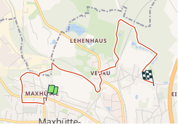
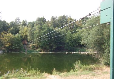
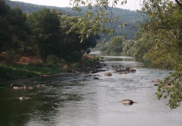
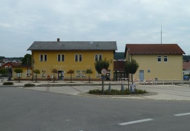
Percorso A piedi di 4,4 km da scoprire a Baviera, Landkreis Schwandorf, Maxhütte-Haidhof. Questo percorso è proposto da SityTrail - itinéraires balisés pédestres.
Descrizione
Trail created by Stadt Burglengenfeld, Stadt Teublitz, Stadt Maxhütte-Haidhof.
Symbol: yellow_round with white 14
Foto
"
data-pinterest-text="Pin it"
data-tweet-text="share on twitter"
data-facebook-share-url="https://www.sitytrail.com/it/trails/3097451-maxhuttexhaidhof--okumenischer-besinnungsweg-thema-xarbeitx/?photo=0#lg=1&slide=0"
data-twitter-share-url="https://www.sitytrail.com/it/trails/3097451-maxhuttexhaidhof--okumenischer-besinnungsweg-thema-xarbeitx/?photo=0#lg=1&slide=0"
data-googleplus-share-url="https://www.sitytrail.com/it/trails/3097451-maxhuttexhaidhof--okumenischer-besinnungsweg-thema-xarbeitx/?photo=0#lg=1&slide=0"
data-pinterest-share-url="https://www.sitytrail.com/it/trails/3097451-maxhuttexhaidhof--okumenischer-besinnungsweg-thema-xarbeitx/?photo=0#lg=1&slide=0">
"
data-pinterest-text="Pin it"
data-tweet-text="share on twitter"
data-facebook-share-url="https://www.sitytrail.com/it/trails/3097451-maxhuttexhaidhof--okumenischer-besinnungsweg-thema-xarbeitx/?photo=1#lg=1&slide=1"
data-twitter-share-url="https://www.sitytrail.com/it/trails/3097451-maxhuttexhaidhof--okumenischer-besinnungsweg-thema-xarbeitx/?photo=1#lg=1&slide=1"
data-googleplus-share-url="https://www.sitytrail.com/it/trails/3097451-maxhuttexhaidhof--okumenischer-besinnungsweg-thema-xarbeitx/?photo=1#lg=1&slide=1"
data-pinterest-share-url="https://www.sitytrail.com/it/trails/3097451-maxhuttexhaidhof--okumenischer-besinnungsweg-thema-xarbeitx/?photo=1#lg=1&slide=1">
"
data-pinterest-text="Pin it"
data-tweet-text="share on twitter"
data-facebook-share-url="https://www.sitytrail.com/it/trails/3097451-maxhuttexhaidhof--okumenischer-besinnungsweg-thema-xarbeitx/?photo=2#lg=1&slide=2"
data-twitter-share-url="https://www.sitytrail.com/it/trails/3097451-maxhuttexhaidhof--okumenischer-besinnungsweg-thema-xarbeitx/?photo=2#lg=1&slide=2"
data-googleplus-share-url="https://www.sitytrail.com/it/trails/3097451-maxhuttexhaidhof--okumenischer-besinnungsweg-thema-xarbeitx/?photo=2#lg=1&slide=2"
data-pinterest-share-url="https://www.sitytrail.com/it/trails/3097451-maxhuttexhaidhof--okumenischer-besinnungsweg-thema-xarbeitx/?photo=2#lg=1&slide=2">
![Percorso A piedi Maxhütte-Haidhof - Ökumenischer Besinnungsweg Thema Percorso A piedi Maxhütte-Haidhof - Ökumenischer Besinnungsweg Thema](https://media.geolcdn.com/t/170/100/36449fe2-4602-493c-bdd5-6c036f3183a9.jpeg&format=jpg&maxdim=2)
![Percorso A piedi Maxhütte-Haidhof - Ökumenischer Besinnungsweg Thema Percorso A piedi Maxhütte-Haidhof - Ökumenischer Besinnungsweg Thema](https://media.geolcdn.com/t/170/100/c914bf07-7efa-46ed-9460-9376ea7cffb3.jpeg&format=jpg&maxdim=2)
![Percorso A piedi Maxhütte-Haidhof - Ökumenischer Besinnungsweg Thema Percorso A piedi Maxhütte-Haidhof - Ökumenischer Besinnungsweg Thema](https://media.geolcdn.com/t/170/100/a1595dee-c876-4e7a-94af-fd87fd8ef38e.jpeg&format=jpg&maxdim=2)
Localizzazione
Paese:
Germany
Regione :
Baviera
Dipartimento/Provincia :
Landkreis Schwandorf
Comune :
Maxhütte-Haidhof
Località :
Unknown
Partenza:(Dec)
Partenza:(UTM)
288302 ; 5453945 (33U) N.
Commenti
Percorsi nelle vicinanze
![Percorso A piedi Regenstauf - Tour 6 »Schwarzbergtour« - Photo](https://media.geolcdn.com/t/375/260/82c6bac3-13b2-423e-8be9-687a1b5300a6.jpeg&format=jpg&maxdim=2)
![A piedi A piedi](https://static1.geolcdn.com/sitytour/trail-icons/100.png)
Tour 6 »Schwarzbergtour«
A piedi
Facile
Regenstauf,
Baviera,
Landkreis Regensburg,
Germany
![](/images/other/stat-length.png)
10,1 km | 13,7 km-effort
3h 6min
![](https://static1.geolcdn.com/siteimages/upload/files/16400158638029165_repeat_loop_refresh_sync_direction_icon.png)
Sì
![Percorso A piedi Maxhütte-Haidhof - Regentalsteig nach Hirschling (Gelbe 8) - Photo](https://media.geolcdn.com/t/375/260/b11983bc-bc26-43bd-9762-2dddd756d7eb.jpeg&format=jpg&maxdim=2)
![A piedi A piedi](https://static1.geolcdn.com/sitytour/trail-icons/100.png)
Regentalsteig nach Hirschling (Gelbe 8)
A piedi
Facile
Maxhütte-Haidhof,
Baviera,
Landkreis Schwandorf,
Germany
![](/images/other/stat-length.png)
8,3 km | 11,6 km-effort
2h 38min
![](https://static1.geolcdn.com/siteimages/upload/files/16400158638029165_repeat_loop_refresh_sync_direction_icon.png)
No
![Percorso A piedi Burglengenfeld - Panoramasteig im Städtedreieck (Dunkelblaue 6) - Photo](https://media.geolcdn.com/t/375/260/204efabd-a7a0-4de3-a754-23817a5a56d3.jpeg&format=jpg&maxdim=2)
![A piedi A piedi](https://static1.geolcdn.com/sitytour/trail-icons/100.png)
Panoramasteig im Städtedreieck (Dunkelblaue 6)
A piedi
Facile
Burglengenfeld,
Baviera,
Landkreis Schwandorf,
Germany
![](/images/other/stat-length.png)
10,2 km | 12,8 km-effort
2h 55min
![](https://static1.geolcdn.com/siteimages/upload/files/16400158638029165_repeat_loop_refresh_sync_direction_icon.png)
No
![Percorso A piedi Burglengenfeld - Städtedreieck-Rundweg 5 (Grün) - Photo](https://media.geolcdn.com/t/375/260/204efabd-a7a0-4de3-a754-23817a5a56d3.jpeg&format=jpg&maxdim=2)
![A piedi A piedi](https://static1.geolcdn.com/sitytour/trail-icons/100.png)
Städtedreieck-Rundweg 5 (Grün)
A piedi
Facile
Burglengenfeld,
Baviera,
Landkreis Schwandorf,
Germany
![](/images/other/stat-length.png)
13,3 km | 16,6 km-effort
3h 46min
![](https://static1.geolcdn.com/siteimages/upload/files/16400158638029165_repeat_loop_refresh_sync_direction_icon.png)
Sì
![Percorso A piedi Burglengenfeld - Städtedreieck-Rundweg 3 (Orange) - Photo](https://media.geolcdn.com/t/375/260/204efabd-a7a0-4de3-a754-23817a5a56d3.jpeg&format=jpg&maxdim=2)
![A piedi A piedi](https://static1.geolcdn.com/sitytour/trail-icons/100.png)
Städtedreieck-Rundweg 3 (Orange)
A piedi
Facile
Burglengenfeld,
Baviera,
Landkreis Schwandorf,
Germany
![](/images/other/stat-length.png)
9,1 km | 10,6 km-effort
2h 24min
![](https://static1.geolcdn.com/siteimages/upload/files/16400158638029165_repeat_loop_refresh_sync_direction_icon.png)
No
![Percorso A piedi Teublitz - O 43 Marienthal - Teublitz (Rotes Dreieck) - Photo](https://media.geolcdn.com/t/375/260/82c6bac3-13b2-423e-8be9-687a1b5300a6.jpeg&format=jpg&maxdim=2)
![A piedi A piedi](https://static1.geolcdn.com/sitytour/trail-icons/100.png)
O 43 Marienthal - Teublitz (Rotes Dreieck)
A piedi
Facile
Teublitz,
Baviera,
Landkreis Schwandorf,
Germany
![](/images/other/stat-length.png)
10,2 km | 11,9 km-effort
2h 42min
![](https://static1.geolcdn.com/siteimages/upload/files/16400158638029165_repeat_loop_refresh_sync_direction_icon.png)
No
![Percorso A piedi Maxhütte-Haidhof - O 78 Leonberg - Ramspau (Rotes Rechteck) - Photo](https://media.geolcdn.com/t/375/260/29b953b4-0667-477d-9468-40f029d19d63.jpeg&format=jpg&maxdim=2)
![A piedi A piedi](https://static1.geolcdn.com/sitytour/trail-icons/100.png)
O 78 Leonberg - Ramspau (Rotes Rechteck)
A piedi
Facile
Maxhütte-Haidhof,
Baviera,
Landkreis Schwandorf,
Germany
![](/images/other/stat-length.png)
5,2 km | 6,7 km-effort
1h 31min
![](https://static1.geolcdn.com/siteimages/upload/files/16400158638029165_repeat_loop_refresh_sync_direction_icon.png)
No
![Percorso A piedi Maxhütte-Haidhof - O 46 Bahnhof Maxhütte-Haidhof - Knotenpunkt Geilenberg (Rotes Rechteck) - Photo](https://media.geolcdn.com/t/375/260/cb8d5781-7b95-400c-afc6-37c26f2edcb0.jpeg&format=jpg&maxdim=2)
![A piedi A piedi](https://static1.geolcdn.com/sitytour/trail-icons/100.png)
O 46 Bahnhof Maxhütte-Haidhof - Knotenpunkt Geilenberg (Rotes Rechteck)
A piedi
Facile
Maxhütte-Haidhof,
Baviera,
Landkreis Schwandorf,
Germany
![](/images/other/stat-length.png)
9 km | 12,8 km-effort
2h 54min
![](https://static1.geolcdn.com/siteimages/upload/files/16400158638029165_repeat_loop_refresh_sync_direction_icon.png)
No
![Percorso A piedi Maxhütte-Haidhof - O 48 Bahnhof Maxhütte-Haidhof - Marienthal (Blaues Rechteck) - Photo](https://media.geolcdn.com/t/375/260/cb8d5781-7b95-400c-afc6-37c26f2edcb0.jpeg&format=jpg&maxdim=2)
![A piedi A piedi](https://static1.geolcdn.com/sitytour/trail-icons/100.png)
O 48 Bahnhof Maxhütte-Haidhof - Marienthal (Blaues Rechteck)
A piedi
Facile
Maxhütte-Haidhof,
Baviera,
Landkreis Schwandorf,
Germany
![](/images/other/stat-length.png)
7,1 km | 9,4 km-effort
2h 8min
![](https://static1.geolcdn.com/siteimages/upload/files/16400158638029165_repeat_loop_refresh_sync_direction_icon.png)
No