![](/images/other/stat-length.png)
![Percorso A piedi Weimar (Lahn) - Naturerlebnispfad Niederwalgern - Photo](https://media.geolcdn.com/t/1900/400/ext.pjpeg?maxdim=2&url=https%3A%2F%2Fmedia.geolcdn.com%2Ff%2F2fcf05ab-bf8a-461d-a25b-c1b8172c29a1.jpeg)
Naturerlebnispfad Niederwalgern
SityTrail - itinéraires balisés pédestres
Tous les sentiers balisés d’Europe PRO
![Lunghezza](/images/other/stat-length.png)
Lunghezza
10,5 km
![Altitudine massima](https://static1.geolcdn.com/siteimages/upload/files/1508320355ic_sort_altitude_max_24dp.png)
Altitudine massima
258 m
![Dislivello positivo](https://static1.geolcdn.com/siteimages/upload/files/1508320355ic_sort_den_pos_24dp.png)
Dislivello positivo
152 m
![Km-Effort](/images/other/stat-length.png)
Km-Effort
12,5 km
![Altitudine minima](https://static1.geolcdn.com/siteimages/upload/files/1508320355ic_sort_altitude_min_24dp.png)
Altitudine minima
167 m
![Dislivello negativo](https://static1.geolcdn.com/siteimages/upload/files/1508320355ic_sort_den_neg_24dp.png)
Dislivello negativo
150 m
![Boucle](https://static1.geolcdn.com/siteimages/upload/files/16400158638029165_repeat_loop_refresh_sync_direction_icon.png)
Boucle
Sì
Tag
Data di creazione :
2022-02-11 17:03:06.777
Ultima modifica :
2022-02-11 17:03:06.777
![A piedi](https://static1.geolcdn.com/sitytour/trail-icons/100.png)
2h50
Difficoltà : Facile
![Scannerizza questo codice QR per aprire il percorso nell'applicazione SityTrail](https://capi.geolives.com/qq0zvz2zws4bq2lad0pu/sitytour/trails/3097232/qr.png?size=200)
Applicazione GPS da escursionismo GRATUITA
Chi siamo
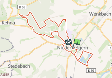
Percorso A piedi di 10,5 km da scoprire a Assia, Landkreis Marburg-Biedenkopf, Weimar (Lahn). Questo percorso è proposto da SityTrail - itinéraires balisés pédestres.
Descrizione
Trail created by Heinzelmännchen Niederwalgern.
Symbol: Roter Punkt auf gelbem Hintergrund
Localizzazione
Paese:
Germany
Regione :
Assia
Dipartimento/Provincia :
Landkreis Marburg-Biedenkopf
Comune :
Weimar (Lahn)
Località :
Unknown
Partenza:(Dec)
Partenza:(UTM)
479047 ; 5620332 (32U) N.
Commenti
Percorsi nelle vicinanze
![Percorso A piedi Weimar (Lahn) - [W1] Rundweg durch die Gemeinde Weimar (Lahn) - Photo](https://media.geolcdn.com/t/375/260/ext.jpg?maxdim=2&url=https%3A%2F%2Fmedia.geolcdn.com%2Ff%2F3bc795d5-8ccb-48ab-b7f6-fe7f27730326.jpeg)
![A piedi A piedi](https://static1.geolcdn.com/sitytour/trail-icons/100.png)
[W1] Rundweg durch die Gemeinde Weimar (Lahn)
A piedi
Molto difficile
Weimar (Lahn),
Assia,
Landkreis Marburg-Biedenkopf,
Germany
![](/images/other/stat-length.png)
50 km | 62 km-effort
14h 3min
![](https://static1.geolcdn.com/siteimages/upload/files/16400158638029165_repeat_loop_refresh_sync_direction_icon.png)
Sì
![Percorso A piedi Weimar (Lahn) - [W8-Alternative] Ortsrundweg Roth - Wolfshausen - Argenstein - Roth - Photo](https://media.geolcdn.com/t/375/260/ext.jpg?maxdim=2&url=https%3A%2F%2Fmedia.geolcdn.com%2Ff%2Fa1b86607-88a4-4848-8acb-0b8e51303bdb.jpeg)
![A piedi A piedi](https://static1.geolcdn.com/sitytour/trail-icons/100.png)
[W8-Alternative] Ortsrundweg Roth - Wolfshausen - Argenstein - Roth
A piedi
Facile
Weimar (Lahn),
Assia,
Landkreis Marburg-Biedenkopf,
Germany
![](/images/other/stat-length.png)
11,4 km | 13,4 km-effort
3h 3min
![](https://static1.geolcdn.com/siteimages/upload/files/16400158638029165_repeat_loop_refresh_sync_direction_icon.png)
Sì
![Percorso A piedi Weimar (Lahn) - [W8] Ortsrundweg Roth - Wolfshausen - Argenstein - Roth-Landsynagoge - Photo](https://media.geolcdn.com/t/375/260/ext.jpg?maxdim=2&url=https%3A%2F%2Fmedia.geolcdn.com%2Ff%2Fa1b86607-88a4-4848-8acb-0b8e51303bdb.jpeg)
![A piedi A piedi](https://static1.geolcdn.com/sitytour/trail-icons/100.png)
[W8] Ortsrundweg Roth - Wolfshausen - Argenstein - Roth-Landsynagoge
A piedi
Facile
Weimar (Lahn),
Assia,
Landkreis Marburg-Biedenkopf,
Germany
![](/images/other/stat-length.png)
11,9 km | 14,1 km-effort
3h 12min
![](https://static1.geolcdn.com/siteimages/upload/files/16400158638029165_repeat_loop_refresh_sync_direction_icon.png)
Sì
![Percorso A piedi Weimar (Lahn) - [W7] Ortsrundweg Niederwalgern - Kehna - Stedebach - Niederwalgern - Photo](https://media.geolcdn.com/t/375/260/ext.jpg?maxdim=2&url=https%3A%2F%2Fmedia.geolcdn.com%2Ff%2F2a98fd64-b158-468b-bf37-6a7c1e3c189d.jpeg)
![A piedi A piedi](https://static1.geolcdn.com/sitytour/trail-icons/100.png)
[W7] Ortsrundweg Niederwalgern - Kehna - Stedebach - Niederwalgern
A piedi
Facile
Weimar (Lahn),
Assia,
Landkreis Marburg-Biedenkopf,
Germany
![](/images/other/stat-length.png)
8,8 km | 10,8 km-effort
2h 26min
![](https://static1.geolcdn.com/siteimages/upload/files/16400158638029165_repeat_loop_refresh_sync_direction_icon.png)
Sì
![Percorso A piedi Weimar (Lahn) - [W3] Ortsrundweg Oberweimar - Allna - Oberweimar - Photo](https://media.geolcdn.com/t/375/260/ext.jpg?maxdim=2&url=https%3A%2F%2Fmedia.geolcdn.com%2Ff%2Ff5153156-6f06-4603-b3b8-7256b8f991b7.jpeg)
![A piedi A piedi](https://static1.geolcdn.com/sitytour/trail-icons/100.png)
[W3] Ortsrundweg Oberweimar - Allna - Oberweimar
A piedi
Facile
Weimar (Lahn),
Assia,
Landkreis Marburg-Biedenkopf,
Germany
![](/images/other/stat-length.png)
6,3 km | 8,2 km-effort
1h 52min
![](https://static1.geolcdn.com/siteimages/upload/files/16400158638029165_repeat_loop_refresh_sync_direction_icon.png)
Sì
![Percorso A piedi Weimar (Lahn) - [W6] Ortsrundweg Niederweimar - Oberweimar - Niederweimar - Photo](https://media.geolcdn.com/t/375/260/ext.jpg?maxdim=2&url=https%3A%2F%2Fmedia.geolcdn.com%2Ff%2F3bc795d5-8ccb-48ab-b7f6-fe7f27730326.jpeg)
![A piedi A piedi](https://static1.geolcdn.com/sitytour/trail-icons/100.png)
[W6] Ortsrundweg Niederweimar - Oberweimar - Niederweimar
A piedi
Facile
Weimar (Lahn),
Assia,
Landkreis Marburg-Biedenkopf,
Germany
![](/images/other/stat-length.png)
10,1 km | 12,8 km-effort
2h 53min
![](https://static1.geolcdn.com/siteimages/upload/files/16400158638029165_repeat_loop_refresh_sync_direction_icon.png)
Sì
![Percorso A piedi Weimar (Lahn) - [W2] Ortsrundweg Oberweimar - Wenkbach - Oberweimar - Photo](https://media.geolcdn.com/t/375/260/ext.jpg?maxdim=2&url=https%3A%2F%2Fmedia.geolcdn.com%2Ff%2F6da0cae2-72c4-47db-9d8f-f58978ab8205.jpeg)
![A piedi A piedi](https://static1.geolcdn.com/sitytour/trail-icons/100.png)
[W2] Ortsrundweg Oberweimar - Wenkbach - Oberweimar
A piedi
Facile
Weimar (Lahn),
Assia,
Landkreis Marburg-Biedenkopf,
Germany
![](/images/other/stat-length.png)
10,9 km | 13,1 km-effort
2h 59min
![](https://static1.geolcdn.com/siteimages/upload/files/16400158638029165_repeat_loop_refresh_sync_direction_icon.png)
Sì
![Percorso Bicicletta Marburg - Duitsland - Lahntal vanaf de bron - Photo](https://media.geolcdn.com/t/375/260/ext.jpg?maxdim=2&url=https%3A%2F%2Fstatic1.geolcdn.com%2Fsiteimages%2Fupload%2Ffiles%2F1524743154velo.jpg)
![Bicicletta Bicicletta](https://static1.geolcdn.com/sitytour/trail-icons/200.png)
Duitsland - Lahntal vanaf de bron
Bicicletta
Molto facile
Marburg,
Assia,
Landkreis Marburg-Biedenkopf,
Germany
![](/images/other/stat-length.png)
146 km | 186 km-effort
Sconosciuto
![](https://static1.geolcdn.com/siteimages/upload/files/16400158638029165_repeat_loop_refresh_sync_direction_icon.png)
Sì