![](/images/other/stat-length.png)
![Percorso A piedi Dirmstein - Chorbrünnel-Rundweg - Photo](https://media.geolcdn.com/t/1900/400/7989779f-d6f8-4dde-9e17-41abb606bc3f.jpeg&format=pjpeg&maxdim=2)
Chorbrünnel-Rundweg
SityTrail - itinéraires balisés pédestres
Tous les sentiers balisés d’Europe GUIDE+
![Lunghezza](/images/other/stat-length.png)
Lunghezza
3,3 km
![Altitudine massima](https://static1.geolcdn.com/siteimages/upload/files/1508320355ic_sort_altitude_max_24dp.png)
Altitudine massima
140 m
![Dislivello positivo](https://static1.geolcdn.com/siteimages/upload/files/1508320355ic_sort_den_pos_24dp.png)
Dislivello positivo
42 m
![Km-Effort](/images/other/stat-length.png)
Km-Effort
3,9 km
![Altitudine minima](https://static1.geolcdn.com/siteimages/upload/files/1508320355ic_sort_altitude_min_24dp.png)
Altitudine minima
106 m
![Dislivello negativo](https://static1.geolcdn.com/siteimages/upload/files/1508320355ic_sort_den_neg_24dp.png)
Dislivello negativo
42 m
![Boucle](https://static1.geolcdn.com/siteimages/upload/files/16400158638029165_repeat_loop_refresh_sync_direction_icon.png)
Boucle
Sì
Tag
Data di creazione :
2022-02-11 16:47:19.32
Ultima modifica :
2022-02-11 16:47:19.32
![A piedi](https://static1.geolcdn.com/sitytour/trail-icons/100.png)
52m
Difficoltà : Facile
![Scannerizza questo codice QR per aprire il percorso nell'applicazione SityTrail](https://capi.geolives.com/qq0zvz2zws4bq2lad0pu/sitytour/trails/3096852/qr.png?size=200)
Applicazione GPS da escursionismo GRATUITA
Chi siamo
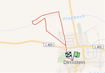
Percorso A piedi di 3,3 km da scoprire a Renania-Palatinato, Landkreis Bad Dürkheim, Dirmstein. Questo percorso è proposto da SityTrail - itinéraires balisés pédestres.
Descrizione
Symbol: grüne Tafel mit schwarzem Rand, orangegelber Steinarkade samt dem rot-blauen Symbol eines Brunnens
Localizzazione
Paese:
Germany
Regione :
Renania-Palatinato
Dipartimento/Provincia :
Landkreis Bad Dürkheim
Comune :
Dirmstein
Località :
Unknown
Partenza:(Dec)
Partenza:(UTM)
445508 ; 5490454 (32U) N.
Commenti
Percorsi nelle vicinanze
![Percorso A piedi Dackenheim - Rundwanderweg 3 (Höningen) - Photo](https://media.geolcdn.com/t/375/260/e6fef176-7f1f-4546-9af7-be9846c7e2bc.jpeg&format=jpg&maxdim=2)
![A piedi A piedi](https://static1.geolcdn.com/sitytour/trail-icons/100.png)
Rundwanderweg 3 (Höningen)
A piedi
Facile
Dackenheim,
Renania-Palatinato,
Landkreis Bad Dürkheim,
Germany
![](/images/other/stat-length.png)
5,2 km | 7,1 km-effort
1h 36min
![](https://static1.geolcdn.com/siteimages/upload/files/16400158638029165_repeat_loop_refresh_sync_direction_icon.png)
Sì
![Percorso A piedi Wachenheim an der Weinstraße - Wachenheim Rundweg Nr. 5 - Photo](https://media.geolcdn.com/t/375/260/e36f20b3-8cd0-4038-9b04-a20360067b83.jpeg&format=jpg&maxdim=2)
![A piedi A piedi](https://static1.geolcdn.com/sitytour/trail-icons/100.png)
Wachenheim Rundweg Nr. 5
A piedi
Facile
Wachenheim an der Weinstraße,
Renania-Palatinato,
Landkreis Bad Dürkheim,
Germany
![](/images/other/stat-length.png)
4,6 km | 5,2 km-effort
1h 11min
![](https://static1.geolcdn.com/siteimages/upload/files/16400158638029165_repeat_loop_refresh_sync_direction_icon.png)
No
![Percorso A piedi Lampertheim - Rundwanderweg Lampertheim Lorscher Weg 2: Rutenfeld-Weg - Photo](https://media.geolcdn.com/t/375/260/87f243ed-c65d-4659-b345-1d72e52e1561.jpeg&format=jpg&maxdim=2)
![A piedi A piedi](https://static1.geolcdn.com/sitytour/trail-icons/100.png)
Rundwanderweg Lampertheim Lorscher Weg 2: Rutenfeld-Weg
A piedi
Facile
Lampertheim,
Assia,
Kreis Bergstraße,
Germany
![](/images/other/stat-length.png)
6,4 km | 7 km-effort
1h 34min
![](https://static1.geolcdn.com/siteimages/upload/files/16400158638029165_repeat_loop_refresh_sync_direction_icon.png)
Sì
![Percorso A piedi Lampertheim - Rundwanderweg Lampertheim Lorscher Weg 3: Wasenacker-Weg - Photo](https://media.geolcdn.com/t/375/260/f1e176e4-946f-4234-9987-3a4c889897fe.jpeg&format=jpg&maxdim=2)
![A piedi A piedi](https://static1.geolcdn.com/sitytour/trail-icons/100.png)
Rundwanderweg Lampertheim Lorscher Weg 3: Wasenacker-Weg
A piedi
Facile
Lampertheim,
Assia,
Kreis Bergstraße,
Germany
![](/images/other/stat-length.png)
8,2 km | 8,8 km-effort
1h 59min
![](https://static1.geolcdn.com/siteimages/upload/files/16400158638029165_repeat_loop_refresh_sync_direction_icon.png)
Sì
![Percorso A piedi Lampertheim - Rundwanderweg Lampertheim Lorscher Weg 4: Oberjägermeister-Weg - Photo](https://media.geolcdn.com/t/375/260/87f243ed-c65d-4659-b345-1d72e52e1561.jpeg&format=jpg&maxdim=2)
![A piedi A piedi](https://static1.geolcdn.com/sitytour/trail-icons/100.png)
Rundwanderweg Lampertheim Lorscher Weg 4: Oberjägermeister-Weg
A piedi
Facile
Lampertheim,
Assia,
Kreis Bergstraße,
Germany
![](/images/other/stat-length.png)
7,3 km | 8 km-effort
1h 48min
![](https://static1.geolcdn.com/siteimages/upload/files/16400158638029165_repeat_loop_refresh_sync_direction_icon.png)
Sì
![Percorso A piedi Biblis - Rundwanderweg Biblis Altwert 2: Altwert-Weg - Photo](https://media.geolcdn.com/t/375/260/acdb3fcf-b415-4c10-88e0-192e35696f04.jpeg&format=jpg&maxdim=2)
![A piedi A piedi](https://static1.geolcdn.com/sitytour/trail-icons/100.png)
Rundwanderweg Biblis Altwert 2: Altwert-Weg
A piedi
Facile
Biblis,
Assia,
Kreis Bergstraße,
Germany
![](/images/other/stat-length.png)
4,7 km | 5,2 km-effort
1h 10min
![](https://static1.geolcdn.com/siteimages/upload/files/16400158638029165_repeat_loop_refresh_sync_direction_icon.png)
No
![Percorso A piedi Biblis - Rundwanderweg Biblis Steiner Wald 1: Züllenstein-Weg - Photo](https://media.geolcdn.com/t/375/260/8976496f-2af5-4cc7-b465-db0bf885c935.jpeg&format=jpg&maxdim=2)
![A piedi A piedi](https://static1.geolcdn.com/sitytour/trail-icons/100.png)
Rundwanderweg Biblis Steiner Wald 1: Züllenstein-Weg
A piedi
Facile
Biblis,
Assia,
Kreis Bergstraße,
Germany
![](/images/other/stat-length.png)
3,6 km | 3,9 km-effort
53min
![](https://static1.geolcdn.com/siteimages/upload/files/16400158638029165_repeat_loop_refresh_sync_direction_icon.png)
No
![Percorso A piedi Lampertheim - Rundwanderweg Biblis Altwert 3: Maulbeerauen-Weg - Photo](https://media.geolcdn.com/t/375/260/acdb3fcf-b415-4c10-88e0-192e35696f04.jpeg&format=jpg&maxdim=2)
![A piedi A piedi](https://static1.geolcdn.com/sitytour/trail-icons/100.png)
Rundwanderweg Biblis Altwert 3: Maulbeerauen-Weg
A piedi
Facile
Lampertheim,
Assia,
Kreis Bergstraße,
Germany
![](/images/other/stat-length.png)
4,7 km | 5,2 km-effort
1h 10min
![](https://static1.geolcdn.com/siteimages/upload/files/16400158638029165_repeat_loop_refresh_sync_direction_icon.png)
No
![Percorso A piedi Monsheim - Zellertalweg - Photo](https://media.geolcdn.com/t/375/260/c84b108a-69ce-422b-880d-e2183a903eca.jpeg&format=jpg&maxdim=2)
![A piedi A piedi](https://static1.geolcdn.com/sitytour/trail-icons/100.png)
Zellertalweg
A piedi
Facile
Monsheim,
Renania-Palatinato,
Landkreis Alzey-Worms,
Germany
![](/images/other/stat-length.png)
9,5 km | 11,7 km-effort
2h 39min
![](https://static1.geolcdn.com/siteimages/upload/files/16400158638029165_repeat_loop_refresh_sync_direction_icon.png)
Sì