![](/images/other/stat-length.png)
![Percorso A piedi Gau-Bischofsheim - Schwarzfelderweg - Photo](https://media.geolcdn.com/t/1900/400/2adab82a-826f-447f-9fe1-fe346655d5ee.jpeg&format=pjpeg&maxdim=2)
Schwarzfelderweg
SityTrail - itinéraires balisés pédestres
Tous les sentiers balisés d’Europe GUIDE+
![Lunghezza](/images/other/stat-length.png)
Lunghezza
3,4 km
![Altitudine massima](https://static1.geolcdn.com/siteimages/upload/files/1508320355ic_sort_altitude_max_24dp.png)
Altitudine massima
148 m
![Dislivello positivo](https://static1.geolcdn.com/siteimages/upload/files/1508320355ic_sort_den_pos_24dp.png)
Dislivello positivo
37 m
![Km-Effort](/images/other/stat-length.png)
Km-Effort
3,9 km
![Altitudine minima](https://static1.geolcdn.com/siteimages/upload/files/1508320355ic_sort_altitude_min_24dp.png)
Altitudine minima
111 m
![Dislivello negativo](https://static1.geolcdn.com/siteimages/upload/files/1508320355ic_sort_den_neg_24dp.png)
Dislivello negativo
39 m
![Boucle](https://static1.geolcdn.com/siteimages/upload/files/16400158638029165_repeat_loop_refresh_sync_direction_icon.png)
Boucle
Sì
Tag
Data di creazione :
2022-02-11 16:28:52.35
Ultima modifica :
2022-02-11 16:28:52.35
![A piedi](https://static1.geolcdn.com/sitytour/trail-icons/100.png)
53m
Difficoltà : Facile
![Scannerizza questo codice QR per aprire il percorso nell'applicazione SityTrail](https://capi.geolives.com/qq0zvz2zws4bq2lad0pu/sitytour/trails/3096380/qr.png?size=200)
Applicazione GPS da escursionismo GRATUITA
Chi siamo
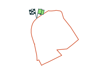
Percorso A piedi di 3,4 km da scoprire a Renania-Palatinato, Landkreis Mainz-Bingen, Gau-Bischofsheim. Questo percorso è proposto da SityTrail - itinéraires balisés pédestres.
Descrizione
Symbol: gelber Römer auf weißem Grund
Localizzazione
Paese:
Germany
Regione :
Renania-Palatinato
Dipartimento/Provincia :
Landkreis Mainz-Bingen
Comune :
Gau-Bischofsheim
Località :
Unknown
Partenza:(Dec)
Partenza:(UTM)
448236 ; 5529321 (32U) N.
Commenti
Percorsi nelle vicinanze
![Percorso A piedi Zornheim - Hiwweltour Zornheimer Berg - Photo](https://media.geolcdn.com/t/375/260/df97a525-789e-43e2-8e9c-e190eea16e11.jpeg&format=jpg&maxdim=2)
![A piedi A piedi](https://static1.geolcdn.com/sitytour/trail-icons/100.png)
Hiwweltour Zornheimer Berg
A piedi
Facile
Zornheim,
Renania-Palatinato,
Landkreis Mainz-Bingen,
Germany
![](/images/other/stat-length.png)
6,8 km | 9,2 km-effort
2h 5min
![](https://static1.geolcdn.com/siteimages/upload/files/16400158638029165_repeat_loop_refresh_sync_direction_icon.png)
Sì
![Percorso A piedi Zornheim - Nordic Walking Zornheim Nr. 3 - Photo](https://media.geolcdn.com/t/375/260/df97a525-789e-43e2-8e9c-e190eea16e11.jpeg&format=jpg&maxdim=2)
![A piedi A piedi](https://static1.geolcdn.com/sitytour/trail-icons/100.png)
Nordic Walking Zornheim Nr. 3
A piedi
Facile
Zornheim,
Renania-Palatinato,
Landkreis Mainz-Bingen,
Germany
![](/images/other/stat-length.png)
6 km | 6,9 km-effort
1h 33min
![](https://static1.geolcdn.com/siteimages/upload/files/16400158638029165_repeat_loop_refresh_sync_direction_icon.png)
Sì
![Percorso A piedi Zornheim - Nordic Walking Zornheim Nr. 2 - Photo](https://media.geolcdn.com/t/375/260/ec2f7315-9175-4f2f-9b0f-017f43864c1e.jpeg&format=jpg&maxdim=2)
![A piedi A piedi](https://static1.geolcdn.com/sitytour/trail-icons/100.png)
Nordic Walking Zornheim Nr. 2
A piedi
Facile
Zornheim,
Renania-Palatinato,
Landkreis Mainz-Bingen,
Germany
![](/images/other/stat-length.png)
5,8 km | 7,2 km-effort
1h 38min
![](https://static1.geolcdn.com/siteimages/upload/files/16400158638029165_repeat_loop_refresh_sync_direction_icon.png)
Sì
![Percorso A piedi Zornheim - Nordic Walking Zornheim Nr. 1 - Photo](https://media.geolcdn.com/t/375/260/df97a525-789e-43e2-8e9c-e190eea16e11.jpeg&format=jpg&maxdim=2)
![A piedi A piedi](https://static1.geolcdn.com/sitytour/trail-icons/100.png)
Nordic Walking Zornheim Nr. 1
A piedi
Facile
Zornheim,
Renania-Palatinato,
Landkreis Mainz-Bingen,
Germany
![](/images/other/stat-length.png)
4,8 km | 5,6 km-effort
1h 15min
![](https://static1.geolcdn.com/siteimages/upload/files/16400158638029165_repeat_loop_refresh_sync_direction_icon.png)
Sì
![Percorso A piedi Gau-Bischofsheim - Panoramaweg - Photo](https://media.geolcdn.com/t/375/260/c4763d1a-06fc-4814-a287-397c95119d27.jpeg&format=jpg&maxdim=2)
![A piedi A piedi](https://static1.geolcdn.com/sitytour/trail-icons/100.png)
Panoramaweg
A piedi
Facile
Gau-Bischofsheim,
Renania-Palatinato,
Landkreis Mainz-Bingen,
Germany
![](/images/other/stat-length.png)
3,4 km | 4,6 km-effort
1h 2min
![](https://static1.geolcdn.com/siteimages/upload/files/16400158638029165_repeat_loop_refresh_sync_direction_icon.png)
Sì
![Percorso A piedi Lörzweiler - Lörzweiler Weinwanderweg - Photo](https://media.geolcdn.com/t/375/260/09e888cd-4afe-4af0-8ff2-c1e2d36b4e5f.jpeg&format=jpg&maxdim=2)
![A piedi A piedi](https://static1.geolcdn.com/sitytour/trail-icons/100.png)
Lörzweiler Weinwanderweg
A piedi
Facile
Lörzweiler,
Renania-Palatinato,
Landkreis Mainz-Bingen,
Germany
![](/images/other/stat-length.png)
4,9 km | 5,7 km-effort
1h 17min
![](https://static1.geolcdn.com/siteimages/upload/files/16400158638029165_repeat_loop_refresh_sync_direction_icon.png)
Sì
![Percorso A piedi Klein-Winternheim - [Rotes Eichenblatt] Mainz (Hbf) - Marienborn - Zahlbach - Photo](https://media.geolcdn.com/t/375/260/29f95c8a-1e3d-4c7e-9ab0-7a1f3486a7e7.jpeg&format=jpg&maxdim=2)
![A piedi A piedi](https://static1.geolcdn.com/sitytour/trail-icons/100.png)
[Rotes Eichenblatt] Mainz (Hbf) - Marienborn - Zahlbach
A piedi
Facile
Klein-Winternheim,
Renania-Palatinato,
Landkreis Mainz-Bingen,
Germany
![](/images/other/stat-length.png)
7,5 km | 8,2 km-effort
1h 51min
![](https://static1.geolcdn.com/siteimages/upload/files/16400158638029165_repeat_loop_refresh_sync_direction_icon.png)
No
![Percorso A piedi Klein-Winternheim - Panoramaweg Klein-Winternheim - Photo](https://media.geolcdn.com/t/375/260/5d7fd195-a0ca-487d-b842-16e84861521c.jpeg&format=jpg&maxdim=2)
![A piedi A piedi](https://static1.geolcdn.com/sitytour/trail-icons/100.png)
Panoramaweg Klein-Winternheim
A piedi
Facile
Klein-Winternheim,
Renania-Palatinato,
Landkreis Mainz-Bingen,
Germany
![](/images/other/stat-length.png)
3,8 km | 4,7 km-effort
1h 3min
![](https://static1.geolcdn.com/siteimages/upload/files/16400158638029165_repeat_loop_refresh_sync_direction_icon.png)
Sì
![Percorso A piedi Nierstein - Drei-Türme-Weg - Photo](https://media.geolcdn.com/t/375/260/ef4d55ed-52ff-4584-aa32-9bd4e0e40d61.jpeg&format=jpg&maxdim=2)
![A piedi A piedi](https://static1.geolcdn.com/sitytour/trail-icons/100.png)
Drei-Türme-Weg
A piedi
Facile
Nierstein,
Renania-Palatinato,
Landkreis Mainz-Bingen,
Germany
![](/images/other/stat-length.png)
3 km | 3,6 km-effort
49min
![](https://static1.geolcdn.com/siteimages/upload/files/16400158638029165_repeat_loop_refresh_sync_direction_icon.png)
No