


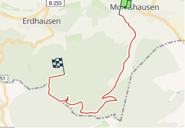

11,1 km | 15 km-effort
![Percorso A piedi Gladenbach - [G7] - Rundweg Gladenbach - Mornshausen - Hüttenmühle - Subach - Teufelsberg - Koppe - Mornshausen - Gladenbach - Photo](https://media.geolcdn.com/t/1900/400/2e5e3f6a-716e-4e97-af2a-b06bf33fb9c3.jpeg&format=pjpeg&maxdim=2)

Tous les sentiers balisés d’Europe GUIDE+


Applicazione GPS da escursionismo GRATUITA
 SityTrail
IGN / Istituti geografici
SityTrail World
Il mondo è tuo
Percorso A piedi di 5,9 km da scoprire a Assia, Landkreis Marburg-Biedenkopf, Gladenbach. Questo percorso è proposto da SityTrail - itinéraires balisés pédestres.
Trail created by Oberhessischer Gebirgsverein.
Symbol: Gelber Text "G7" auf schwarzem Hintergrund
![Percorso A piedi Gladenbach - [G7] - Rundweg Gladenbach - Mornshausen - Hüttenmühle - Subach - Teufelsberg - Koppe - Mornshausen - Gladenbach - Photo 1](https://media.geolcdn.com/t/2048/auto/48566ef0-c627-4ca8-8fbb-0eb73f4c1fd7.jpeg&format=jpg&maxdim=0 "Percorso A piedi Gladenbach - [G7] - Rundweg Gladenbach - Mornshausen - Hüttenmühle - Subach - Teufelsberg - Koppe - Mornshausen - Gladenbach - Photo 1")
![Percorso A piedi Gladenbach - [G7] - Rundweg Gladenbach - Mornshausen - Hüttenmühle - Subach - Teufelsberg - Koppe - Mornshausen - Gladenbach - Photo 2](https://media.geolcdn.com/t/2048/auto/5c580ec8-70c3-4cf7-9d81-244236a7b39c.jpeg&format=jpg&maxdim=0 "Percorso A piedi Gladenbach - [G7] - Rundweg Gladenbach - Mornshausen - Hüttenmühle - Subach - Teufelsberg - Koppe - Mornshausen - Gladenbach - Photo 2")
![Percorso A piedi Gladenbach - [G7] - Rundweg Gladenbach - Mornshausen - Hüttenmühle - Subach - Teufelsberg - Koppe - Mornshausen - Gladenbach - Photo 3](https://media.geolcdn.com/t/2048/auto/a0f77866-b875-40e5-9e13-35ac7250ff5c.jpeg&format=jpg&maxdim=0 "Percorso A piedi Gladenbach - [G7] - Rundweg Gladenbach - Mornshausen - Hüttenmühle - Subach - Teufelsberg - Koppe - Mornshausen - Gladenbach - Photo 3")
![Percorso A piedi Gladenbach - [G7] - Rundweg Gladenbach - Mornshausen - Hüttenmühle - Subach - Teufelsberg - Koppe - Mornshausen - Gladenbach - Photo 4](https://media.geolcdn.com/t/2048/auto/7b3feb7a-217c-404d-a364-ab925038a5fd.jpeg&format=jpg&maxdim=0 "Percorso A piedi Gladenbach - [G7] - Rundweg Gladenbach - Mornshausen - Hüttenmühle - Subach - Teufelsberg - Koppe - Mornshausen - Gladenbach - Photo 4")
![Percorso A piedi Gladenbach - [G7] - Rundweg Gladenbach - Mornshausen - Hüttenmühle - Subach - Teufelsberg - Koppe - Mornshausen - Gladenbach - Photo 5](https://media.geolcdn.com/t/2048/auto/b6c0f62c-89d4-4411-8f85-50187332ef47.jpeg&format=jpg&maxdim=0 "Percorso A piedi Gladenbach - [G7] - Rundweg Gladenbach - Mornshausen - Hüttenmühle - Subach - Teufelsberg - Koppe - Mornshausen - Gladenbach - Photo 5")
![Percorso A piedi Gladenbach - [G7] - Rundweg Gladenbach - Mornshausen - Hüttenmühle - Subach - Teufelsberg - Koppe - Mornshausen - Gladenbach - Photo 6](https://media.geolcdn.com/t/2048/auto/9b83bb73-9026-4908-b1b2-4e0c4ed548b4.jpeg&format=jpg&maxdim=0 "Percorso A piedi Gladenbach - [G7] - Rundweg Gladenbach - Mornshausen - Hüttenmühle - Subach - Teufelsberg - Koppe - Mornshausen - Gladenbach - Photo 6")
![Percorso A piedi Gladenbach - [G7] - Rundweg Gladenbach - Mornshausen - Hüttenmühle - Subach - Teufelsberg - Koppe - Mornshausen - Gladenbach - Photo 7](https://media.geolcdn.com/t/2048/auto/8756c530-fd75-479f-a3ab-4468981d5395.jpeg&format=jpg&maxdim=0 "Percorso A piedi Gladenbach - [G7] - Rundweg Gladenbach - Mornshausen - Hüttenmühle - Subach - Teufelsberg - Koppe - Mornshausen - Gladenbach - Photo 7")
![Percorso A piedi Gladenbach - [G7] - Rundweg Gladenbach - Mornshausen - Hüttenmühle - Subach - Teufelsberg - Koppe - Mornshausen - Gladenbach - Photo 8](https://media.geolcdn.com/t/2048/auto/39e2db77-7db9-4426-bbac-74b3bf3b0d5c.jpeg&format=jpg&maxdim=0 "Percorso A piedi Gladenbach - [G7] - Rundweg Gladenbach - Mornshausen - Hüttenmühle - Subach - Teufelsberg - Koppe - Mornshausen - Gladenbach - Photo 8")
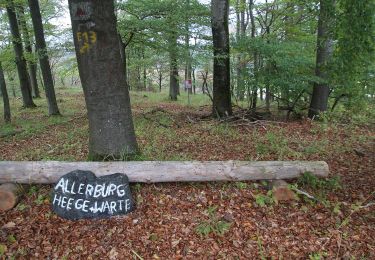
![Percorso A piedi Gladenbach - [G7] - Rundweg Gladenbach - Mornshausen - Hüttenmühle - Subach - Teufelsberg - Koppe - Mornshausen - Gladenbach - Photo 9](https://media.geolcdn.com/t/2048/auto/2e5e3f6a-716e-4e97-af2a-b06bf33fb9c3.jpeg&format=jpg&maxdim=0 "Percorso A piedi Gladenbach - [G7] - Rundweg Gladenbach - Mornshausen - Hüttenmühle - Subach - Teufelsberg - Koppe - Mornshausen - Gladenbach - Photo 9")
![Percorso A piedi Gladenbach - [G7] - Rundweg Gladenbach - Mornshausen - Hüttenmühle - Subach - Teufelsberg - Koppe - Mornshausen - Gladenbach - Photo 10](https://media.geolcdn.com/t/2048/auto/dcdbe836-fae7-48e8-803d-b0b4ea1dca94.jpeg&format=jpg&maxdim=0 "Percorso A piedi Gladenbach - [G7] - Rundweg Gladenbach - Mornshausen - Hüttenmühle - Subach - Teufelsberg - Koppe - Mornshausen - Gladenbach - Photo 10")
A piedi
![Percorso A piedi Gladenbach - [G4] - Rundweg Gladenbach - Reithalle - alter Pflanzengarten - Rachelshausen - Kehlnbach - Kehlnbachtal - Gladenbach - Photo](https://media.geolcdn.com/t/375/260/5102141e-d951-49fc-98e6-521cd239ef3d.jpeg&format=jpg&maxdim=2)
A piedi
![Percorso A piedi Gladenbach - [G12] - Rundweg Gladenbach - Ruine Blankenstein - Kehlnbach - Römershausen - Rachelshausen - Runzhausen - Schutzhütte Kehlnbach - Gladenbach - Photo](https://media.geolcdn.com/t/375/260/9a55fbee-7b56-4a3a-8921-e1e04f3645be.jpeg&format=jpg&maxdim=2)
A piedi
![Percorso A piedi Gladenbach - [G11] - Rundweg Gladenbach - Ammenhausen - Friebertshausen - Wolfskapelle - Altes Forsthaus Rüchenbach - Ammenhausen - Gladenbach - Photo](https://media.geolcdn.com/t/375/260/74d81b5d-74eb-484a-be77-6338fb44592d.jpeg&format=jpg&maxdim=2)
A piedi
A piedi
A piedi
![Percorso A piedi Gladenbach - [G2] - Rundweg Gladenbach - Bruchmühle - Sportplatz Erdhausen - Koppe - Mornshausen - Gladenbach - Photo](https://media.geolcdn.com/t/375/260/0190eb51-e3e1-4683-bae1-1b15eaf6b48c.jpeg&format=jpg&maxdim=2)
A piedi
A piedi
A piedi