![](/images/other/stat-length.png)
![Percorso A piedi Langscheid - Wacholderweg - Photo](https://media.geolcdn.com/t/1900/400/df2bc356-4117-4c05-9360-e9b6f3d66f76.jpeg&format=pjpeg&maxdim=2)
Wacholderweg
SityTrail - itinéraires balisés pédestres
Tous les sentiers balisés d’Europe GUIDE+
![Lunghezza](/images/other/stat-length.png)
Lunghezza
7,2 km
![Altitudine massima](https://static1.geolcdn.com/siteimages/upload/files/1508320355ic_sort_altitude_max_24dp.png)
Altitudine massima
580 m
![Dislivello positivo](https://static1.geolcdn.com/siteimages/upload/files/1508320355ic_sort_den_pos_24dp.png)
Dislivello positivo
253 m
![Km-Effort](/images/other/stat-length.png)
Km-Effort
10,2 km
![Altitudine minima](https://static1.geolcdn.com/siteimages/upload/files/1508320355ic_sort_altitude_min_24dp.png)
Altitudine minima
388 m
![Dislivello negativo](https://static1.geolcdn.com/siteimages/upload/files/1508320355ic_sort_den_neg_24dp.png)
Dislivello negativo
147 m
![Boucle](https://static1.geolcdn.com/siteimages/upload/files/16400158638029165_repeat_loop_refresh_sync_direction_icon.png)
Boucle
No
Tag
Data di creazione :
2022-02-11 16:08:43.223
Ultima modifica :
2022-02-11 16:08:43.223
![A piedi](https://static1.geolcdn.com/sitytour/trail-icons/100.png)
2h19
Difficoltà : Facile
![Scannerizza questo codice QR per aprire il percorso nell'applicazione SityTrail](https://capi.geolives.com/qq0zvz2zws4bq2lad0pu/sitytour/trails/3095814/qr.png?size=200)
Applicazione GPS da escursionismo GRATUITA
Chi siamo
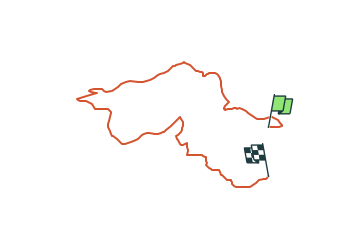
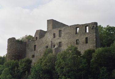
Percorso A piedi di 7,2 km da scoprire a Renania-Palatinato, Landkreis Mayen-Koblenz, Langscheid. Questo percorso è proposto da SityTrail - itinéraires balisés pédestres.
Descrizione
Trail created by Rhein-Mosel-Eifel-Touristik.
Symbol: Oranger Hintergrund - Weißer Pfad - Text: Traumpfade
Localizzazione
Paese:
Germany
Regione :
Renania-Palatinato
Dipartimento/Provincia :
Landkreis Mayen-Koblenz
Comune :
Langscheid
Località :
Unknown
Partenza:(Dec)
Partenza:(UTM)
365542 ; 5583477 (32U) N.
Commenti
Percorsi nelle vicinanze
![Percorso A piedi Acht - Wanderather - Photo](https://media.geolcdn.com/t/375/260/b277f1c9-e116-4561-a875-5a24a219b12f.jpeg&format=jpg&maxdim=2)
![A piedi A piedi](https://static1.geolcdn.com/sitytour/trail-icons/100.png)
Wanderather
A piedi
Facile
Acht,
Renania-Palatinato,
Landkreis Mayen-Koblenz,
Germany
![](/images/other/stat-length.png)
12,4 km | 17,1 km-effort
3h 52min
![](https://static1.geolcdn.com/siteimages/upload/files/16400158638029165_repeat_loop_refresh_sync_direction_icon.png)
No
![Percorso A piedi Rieden - Traumpfad Riedener See - Photo](https://media.geolcdn.com/t/375/260/0eee0a8d-7b40-4ca8-b00c-c42f3103e77d.jpeg&format=jpg&maxdim=2)
![A piedi A piedi](https://static1.geolcdn.com/sitytour/trail-icons/100.png)
Traumpfad Riedener See
A piedi
Facile
Rieden,
Renania-Palatinato,
Landkreis Mayen-Koblenz,
Germany
![](/images/other/stat-length.png)
11,4 km | 16 km-effort
3h 38min
![](https://static1.geolcdn.com/siteimages/upload/files/16400158638029165_repeat_loop_refresh_sync_direction_icon.png)
No
![Percorso A piedi Mayen - Eifel-Traumpfad Förstersteig - Photo](https://media.geolcdn.com/t/375/260/8b43a2e6-3bc2-41b8-be4f-03d51604523a.jpeg&format=jpg&maxdim=2)
![A piedi A piedi](https://static1.geolcdn.com/sitytour/trail-icons/100.png)
Eifel-Traumpfad Förstersteig
A piedi
Medio
Mayen,
Renania-Palatinato,
Landkreis Mayen-Koblenz,
Germany
![](/images/other/stat-length.png)
14,5 km | 22 km-effort
5h 2min
![](https://static1.geolcdn.com/siteimages/upload/files/16400158638029165_repeat_loop_refresh_sync_direction_icon.png)
Sì
![Percorso A piedi Mayen - DE-8 - Photo](https://media.geolcdn.com/t/375/260/8b43a2e6-3bc2-41b8-be4f-03d51604523a.jpeg&format=jpg&maxdim=2)
![A piedi A piedi](https://static1.geolcdn.com/sitytour/trail-icons/100.png)
DE-8
A piedi
Facile
Mayen,
Renania-Palatinato,
Landkreis Mayen-Koblenz,
Germany
![](/images/other/stat-length.png)
4,4 km | 5,9 km-effort
1h 21min
![](https://static1.geolcdn.com/siteimages/upload/files/16400158638029165_repeat_loop_refresh_sync_direction_icon.png)
No
![Percorso A piedi Virneburg - Virne-Burgweg - Photo](https://media.geolcdn.com/t/375/260/52cd3d8b-4f1b-4585-af5c-d7774d6fba90.jpeg&format=jpg&maxdim=2)
![A piedi A piedi](https://static1.geolcdn.com/sitytour/trail-icons/100.png)
Virne-Burgweg
A piedi
Facile
Virneburg,
Renania-Palatinato,
Landkreis Mayen-Koblenz,
Germany
![](/images/other/stat-length.png)
9,8 km | 13,7 km-effort
3h 6min
![](https://static1.geolcdn.com/siteimages/upload/files/16400158638029165_repeat_loop_refresh_sync_direction_icon.png)
Sì
![Percorso A piedi Hohenleimbach - [③] Rundweg Heckenbach 3 - Photo](https://media.geolcdn.com/t/375/260/ext.jpg?maxdim=2&url=https%3A%2F%2Fstatic1.geolcdn.com%2Fsiteimages%2Fupload%2Ffiles%2F1545311037marcheuse_200dpi.jpg)
![A piedi A piedi](https://static1.geolcdn.com/sitytour/trail-icons/100.png)
[③] Rundweg Heckenbach 3
A piedi
Facile
Hohenleimbach,
Renania-Palatinato,
Landkreis Ahrweiler,
Germany
![](/images/other/stat-length.png)
7,4 km | 9,6 km-effort
2h 10min
![](https://static1.geolcdn.com/siteimages/upload/files/16400158638029165_repeat_loop_refresh_sync_direction_icon.png)
No
![Percorso Marcia Kempenich - nb - Photo](https://media.geolcdn.com/t/375/260/ext.jpg?maxdim=2&url=https%3A%2F%2Fstatic1.geolcdn.com%2Fsiteimages%2Fupload%2Ffiles%2F1553511878bg_sport_marche.png)
![Marcia Marcia](https://static1.geolcdn.com/sitytour/trail-icons/101.png)
nb
Marcia
Molto difficile
Kempenich,
Renania-Palatinato,
Landkreis Ahrweiler,
Germany
![](/images/other/stat-length.png)
16,2 km | 23 km-effort
3h 24min
![](https://static1.geolcdn.com/siteimages/upload/files/16400158638029165_repeat_loop_refresh_sync_direction_icon.png)
No
![Percorso Marcia Arft - Trumpfade Arft et sa rivière à descendre voir. - Photo](https://media.geolcdn.com/t/375/260/ext.jpg?maxdim=2&url=https%3A%2F%2Fstatic1.geolcdn.com%2Fsiteimages%2Fupload%2Ffiles%2F1553511878bg_sport_marche.png)
![Marcia Marcia](https://static1.geolcdn.com/sitytour/trail-icons/101.png)
Trumpfade Arft et sa rivière à descendre voir.
Marcia
Facile
Arft,
Renania-Palatinato,
Landkreis Mayen-Koblenz,
Germany
![](/images/other/stat-length.png)
10,3 km | 14,3 km-effort
2h 48min
![](https://static1.geolcdn.com/siteimages/upload/files/16400158638029165_repeat_loop_refresh_sync_direction_icon.png)
Sì