


23 km | 30 km-effort
![Percorso A piedi Weimar (Lahn) - [W3] Ortsrundweg Oberweimar - Allna - Oberweimar - Photo](https://media.geolcdn.com/t/1900/400/f5153156-6f06-4603-b3b8-7256b8f991b7.jpeg&format=pjpeg&maxdim=2)

Tous les sentiers balisés d’Europe GUIDE+


Applicazione GPS da escursionismo GRATUITA
 SityTrail
IGN / Istituti geografici
SityTrail World
Il mondo è tuo
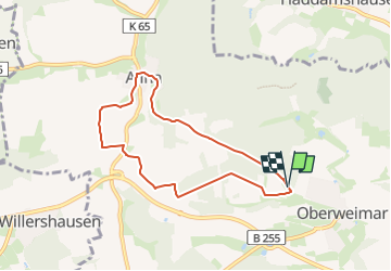
Percorso A piedi di 6,3 km da scoprire a Assia, Landkreis Marburg-Biedenkopf, Weimar (Lahn). Questo percorso è proposto da SityTrail - itinéraires balisés pédestres.
Trail created by Gemeinde Weimar (Lahn).
Symbol: Gelber Text "W3" auf schwarzem Hintergrund
![Percorso A piedi Weimar (Lahn) - [W3] Ortsrundweg Oberweimar - Allna - Oberweimar - Photo 1](https://media.geolcdn.com/t/2048/auto/65fbafd8-793d-4843-b991-ba9668cc990d.jpeg&format=jpg&maxdim=0 "Percorso A piedi Weimar (Lahn) - [W3] Ortsrundweg Oberweimar - Allna - Oberweimar - Photo 1")
![Percorso A piedi Weimar (Lahn) - [W3] Ortsrundweg Oberweimar - Allna - Oberweimar - Photo 2](https://media.geolcdn.com/t/2048/auto/4a7d15c9-a40e-4699-909f-37d414decb70.jpeg&format=jpg&maxdim=0 "Percorso A piedi Weimar (Lahn) - [W3] Ortsrundweg Oberweimar - Allna - Oberweimar - Photo 2")
![Percorso A piedi Weimar (Lahn) - [W3] Ortsrundweg Oberweimar - Allna - Oberweimar - Photo 3](https://media.geolcdn.com/t/2048/auto/3b0c86a6-1a4e-42f4-8641-0ef3c754c194.jpeg&format=jpg&maxdim=0 "Percorso A piedi Weimar (Lahn) - [W3] Ortsrundweg Oberweimar - Allna - Oberweimar - Photo 3")
![Percorso A piedi Weimar (Lahn) - [W3] Ortsrundweg Oberweimar - Allna - Oberweimar - Photo 4](https://media.geolcdn.com/t/2048/auto/a3e35954-7570-44fa-919d-f2f8aa7cca97.jpeg&format=jpg&maxdim=0 "Percorso A piedi Weimar (Lahn) - [W3] Ortsrundweg Oberweimar - Allna - Oberweimar - Photo 4")
![Percorso A piedi Weimar (Lahn) - [W3] Ortsrundweg Oberweimar - Allna - Oberweimar - Photo 5](https://media.geolcdn.com/t/2048/auto/b9bc3716-b6c8-4bc5-9b11-08b39f4ac316.jpeg&format=jpg&maxdim=0 "Percorso A piedi Weimar (Lahn) - [W3] Ortsrundweg Oberweimar - Allna - Oberweimar - Photo 5")
![Percorso A piedi Weimar (Lahn) - [W3] Ortsrundweg Oberweimar - Allna - Oberweimar - Photo 6](https://media.geolcdn.com/t/2048/auto/7d88704a-c17d-48de-aded-dbd8c75dd524.jpeg&format=jpg&maxdim=0 "Percorso A piedi Weimar (Lahn) - [W3] Ortsrundweg Oberweimar - Allna - Oberweimar - Photo 6")
![Percorso A piedi Weimar (Lahn) - [W3] Ortsrundweg Oberweimar - Allna - Oberweimar - Photo 7](https://media.geolcdn.com/t/2048/auto/79a98684-3fea-48d3-a71a-14f35103765d.jpeg&format=jpg&maxdim=0 "Percorso A piedi Weimar (Lahn) - [W3] Ortsrundweg Oberweimar - Allna - Oberweimar - Photo 7")
![Percorso A piedi Weimar (Lahn) - [W3] Ortsrundweg Oberweimar - Allna - Oberweimar - Photo 8](https://media.geolcdn.com/t/2048/auto/914bf561-3279-43d6-a1cd-3190610c60bf.jpeg&format=jpg&maxdim=0 "Percorso A piedi Weimar (Lahn) - [W3] Ortsrundweg Oberweimar - Allna - Oberweimar - Photo 8")
![Percorso A piedi Weimar (Lahn) - [W3] Ortsrundweg Oberweimar - Allna - Oberweimar - Photo 9](https://media.geolcdn.com/t/2048/auto/f5153156-6f06-4603-b3b8-7256b8f991b7.jpeg&format=jpg&maxdim=0 "Percorso A piedi Weimar (Lahn) - [W3] Ortsrundweg Oberweimar - Allna - Oberweimar - Photo 9")
![Percorso A piedi Weimar (Lahn) - [W3] Ortsrundweg Oberweimar - Allna - Oberweimar - Photo 10](https://media.geolcdn.com/t/2048/auto/29db04a5-46b7-4e72-9137-fe47e864b39f.jpeg&format=jpg&maxdim=0 "Percorso A piedi Weimar (Lahn) - [W3] Ortsrundweg Oberweimar - Allna - Oberweimar - Photo 10")
A piedi
A piedi
A piedi
![Percorso A piedi Marburg - [D3] Rundwanderweg Stadtwald Niederweimar - Photo](https://media.geolcdn.com/t/375/260/5315a4e8-56d7-4a23-9b53-67ad8b3b0bac.jpeg&format=jpg&maxdim=2)
A piedi
![Percorso A piedi Marburg - [D6] Rundwanderweg Rumpeltal - Photo](https://media.geolcdn.com/t/375/260/f5b1abdc-c4ab-41bf-89af-120541dea1b9.jpeg&format=jpg&maxdim=2)
A piedi
A piedi
![Percorso A piedi Marburg - [D1] Rundwanderweg Wilhelmsplatz Dammühle - Photo](https://media.geolcdn.com/t/375/260/0cc66262-e528-4ca7-8069-41822758b30f.jpeg&format=jpg&maxdim=2)
A piedi
![Percorso A piedi Weimar (Lahn) - [W1] Rundweg durch die Gemeinde Weimar (Lahn) - Photo](https://media.geolcdn.com/t/375/260/3bc795d5-8ccb-48ab-b7f6-fe7f27730326.jpeg&format=jpg&maxdim=2)
A piedi
![Percorso A piedi Weimar (Lahn) - [W8-Alternative] Ortsrundweg Roth - Wolfshausen - Argenstein - Roth - Photo](https://media.geolcdn.com/t/375/260/a1b86607-88a4-4848-8acb-0b8e51303bdb.jpeg&format=jpg&maxdim=2)
A piedi