![](/images/other/stat-length.png)
![Percorso A piedi Grassau - eon - Trail - Photo](https://media.geolcdn.com/t/1900/400/601be0dc-08da-414f-ba1d-ce5a53e79f8c.jpeg&format=pjpeg&maxdim=2)
eon - Trail
SityTrail - itinéraires balisés pédestres
Tous les sentiers balisés d’Europe GUIDE+
![Lunghezza](/images/other/stat-length.png)
Lunghezza
6,9 km
![Altitudine massima](https://static1.geolcdn.com/siteimages/upload/files/1508320355ic_sort_altitude_max_24dp.png)
Altitudine massima
648 m
![Dislivello positivo](https://static1.geolcdn.com/siteimages/upload/files/1508320355ic_sort_den_pos_24dp.png)
Dislivello positivo
163 m
![Km-Effort](/images/other/stat-length.png)
Km-Effort
9 km
![Altitudine minima](https://static1.geolcdn.com/siteimages/upload/files/1508320355ic_sort_altitude_min_24dp.png)
Altitudine minima
534 m
![Dislivello negativo](https://static1.geolcdn.com/siteimages/upload/files/1508320355ic_sort_den_neg_24dp.png)
Dislivello negativo
163 m
![Boucle](https://static1.geolcdn.com/siteimages/upload/files/16400158638029165_repeat_loop_refresh_sync_direction_icon.png)
Boucle
No
Tag
Data di creazione :
2022-02-11 15:22:55.489
Ultima modifica :
2022-02-11 15:22:55.489
![A piedi](https://static1.geolcdn.com/sitytour/trail-icons/100.png)
2h03
Difficoltà : Facile
![Scannerizza questo codice QR per aprire il percorso nell'applicazione SityTrail](https://capi.geolives.com/qq0zvz2zws4bq2lad0pu/sitytour/trails/3094387/qr.png?size=200)
Applicazione GPS da escursionismo GRATUITA
Chi siamo
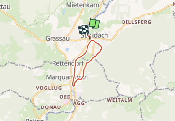
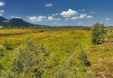
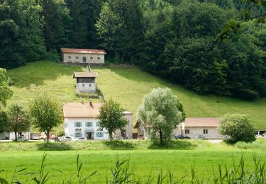
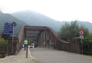
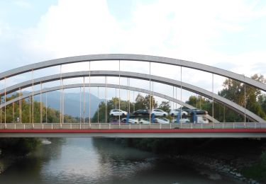
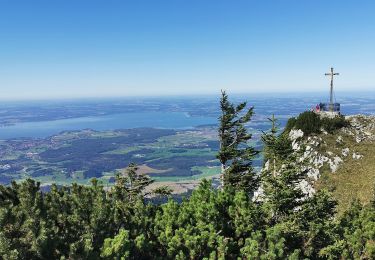
Percorso A piedi di 6,9 km da scoprire a Baviera, Landkreis Traunstein, Grassau. Questo percorso è proposto da SityTrail - itinéraires balisés pédestres.
Descrizione
Trail created by DSV nordic aktiv AUSBILDUNGSZENTRUM Grassau Bayern am Chiemsee.
Symbol: Rotes Schild mit weißem Pfeil
Localizzazione
Paese:
Germany
Regione :
Baviera
Dipartimento/Provincia :
Landkreis Traunstein
Comune :
Grassau
Località :
Unknown
Partenza:(Dec)
Partenza:(UTM)
310886 ; 5295060 (33T) N.
Commenti
Percorsi nelle vicinanze
![Percorso A piedi Marquartstein - SalzAlpenTour - Marquartstein - Photo](https://media.geolcdn.com/t/375/260/6a08c7a4-18e6-432b-8d18-6c58893e510c.jpeg&format=jpg&maxdim=2)
![A piedi A piedi](https://static1.geolcdn.com/sitytour/trail-icons/100.png)
SalzAlpenTour - Marquartstein
A piedi
Facile
Marquartstein,
Baviera,
Landkreis Traunstein,
Germany
![](/images/other/stat-length.png)
3,2 km | 4,9 km-effort
1h 6min
![](https://static1.geolcdn.com/siteimages/upload/files/16400158638029165_repeat_loop_refresh_sync_direction_icon.png)
No
![Percorso A piedi Grassau - Wanderweg 4 - Grassau - Photo](https://media.geolcdn.com/t/375/260/d24c11c6-c82e-4efd-b811-b1ed9001aaff.jpeg&format=jpg&maxdim=2)
![A piedi A piedi](https://static1.geolcdn.com/sitytour/trail-icons/100.png)
Wanderweg 4 - Grassau
A piedi
Facile
Grassau,
Baviera,
Landkreis Traunstein,
Germany
![](/images/other/stat-length.png)
6,3 km | 13 km-effort
2h 57min
![](https://static1.geolcdn.com/siteimages/upload/files/16400158638029165_repeat_loop_refresh_sync_direction_icon.png)
No
![Percorso A piedi Grassau - Wanderweg 23 - Grassau - Photo](https://media.geolcdn.com/t/375/260/939b449c-8bfe-4713-8ba8-45392e182414.jpeg&format=jpg&maxdim=2)
![A piedi A piedi](https://static1.geolcdn.com/sitytour/trail-icons/100.png)
Wanderweg 23 - Grassau
A piedi
Facile
Grassau,
Baviera,
Landkreis Traunstein,
Germany
![](/images/other/stat-length.png)
5,7 km | 6,2 km-effort
1h 24min
![](https://static1.geolcdn.com/siteimages/upload/files/16400158638029165_repeat_loop_refresh_sync_direction_icon.png)
No
![Percorso A piedi Staudach-Egerndach - Wanderweg 1 - Grassau - Photo](https://media.geolcdn.com/t/375/260/601be0dc-08da-414f-ba1d-ce5a53e79f8c.jpeg&format=jpg&maxdim=2)
![A piedi A piedi](https://static1.geolcdn.com/sitytour/trail-icons/100.png)
Wanderweg 1 - Grassau
A piedi
Facile
Staudach-Egerndach,
Baviera,
Landkreis Traunstein,
Germany
![](/images/other/stat-length.png)
4,1 km | 4,4 km-effort
1h 0min
![](https://static1.geolcdn.com/siteimages/upload/files/16400158638029165_repeat_loop_refresh_sync_direction_icon.png)
No
![Percorso A piedi Grassau - SalzAlpenTour - Über die Grassauer Almen - Photo](https://media.geolcdn.com/t/375/260/5cc8f884-fa03-4b69-aeeb-fdd283aca3e7.jpeg&format=jpg&maxdim=2)
![A piedi A piedi](https://static1.geolcdn.com/sitytour/trail-icons/100.png)
SalzAlpenTour - Über die Grassauer Almen
A piedi
Facile
Grassau,
Baviera,
Landkreis Traunstein,
Germany
![](/images/other/stat-length.png)
10,6 km | 18,7 km-effort
4h 14min
![](https://static1.geolcdn.com/siteimages/upload/files/16400158638029165_repeat_loop_refresh_sync_direction_icon.png)
No
![Percorso A piedi Grassau - Haas - Trail - Photo](https://media.geolcdn.com/t/375/260/457a24b3-c1bf-43db-afd7-f27dcbdf84a9.jpeg&format=jpg&maxdim=2)
![A piedi A piedi](https://static1.geolcdn.com/sitytour/trail-icons/100.png)
Haas - Trail
A piedi
Facile
Grassau,
Baviera,
Landkreis Traunstein,
Germany
![](/images/other/stat-length.png)
7,4 km | 10,2 km-effort
2h 18min
![](https://static1.geolcdn.com/siteimages/upload/files/16400158638029165_repeat_loop_refresh_sync_direction_icon.png)
No
![Percorso A piedi Marquartstein - Wanderweg 12 - Staudach - Photo](https://media.geolcdn.com/t/375/260/457a24b3-c1bf-43db-afd7-f27dcbdf84a9.jpeg&format=jpg&maxdim=2)
![A piedi A piedi](https://static1.geolcdn.com/sitytour/trail-icons/100.png)
Wanderweg 12 - Staudach
A piedi
Facile
Marquartstein,
Baviera,
Landkreis Traunstein,
Germany
![](/images/other/stat-length.png)
3,2 km | 3,4 km-effort
46min
![](https://static1.geolcdn.com/siteimages/upload/files/16400158638029165_repeat_loop_refresh_sync_direction_icon.png)
No
![Percorso A piedi Übersee - eon - Trail - Photo](https://media.geolcdn.com/t/375/260/70708853-27ea-456e-8329-837fef18fa69.jpeg&format=jpg&maxdim=2)
![A piedi A piedi](https://static1.geolcdn.com/sitytour/trail-icons/100.png)
eon - Trail
A piedi
Facile
Übersee,
Baviera,
Landkreis Traunstein,
Germany
![](/images/other/stat-length.png)
8,7 km | 9,5 km-effort
2h 9min
![](https://static1.geolcdn.com/siteimages/upload/files/16400158638029165_repeat_loop_refresh_sync_direction_icon.png)
Sì
![Percorso A piedi Grassau - Wanderweg 21 - Rottau/Übersee - Photo](https://media.geolcdn.com/t/375/260/728197dc-3f85-4c0b-9c64-e77d3b389e64.jpeg&format=jpg&maxdim=2)
![A piedi A piedi](https://static1.geolcdn.com/sitytour/trail-icons/100.png)
Wanderweg 21 - Rottau/Übersee
A piedi
Facile
Grassau,
Baviera,
Landkreis Traunstein,
Germany
![](/images/other/stat-length.png)
6,3 km | 7,5 km-effort
1h 42min
![](https://static1.geolcdn.com/siteimages/upload/files/16400158638029165_repeat_loop_refresh_sync_direction_icon.png)
No