![](/images/other/stat-length.png)
![Percorso A piedi Rott am Inn - Innauenweg - Photo](https://media.geolcdn.com/t/1900/400/ext.pjpeg?maxdim=2&url=https%3A%2F%2Fmedia.geolcdn.com%2Ff%2Ff1255ee4-e390-4d9a-acd6-1324e0744a2c.jpeg)
Innauenweg
SityTrail - itinéraires balisés pédestres
Tous les sentiers balisés d’Europe PRO
![Lunghezza](/images/other/stat-length.png)
Lunghezza
7,2 km
![Altitudine massima](https://static1.geolcdn.com/siteimages/upload/files/1508320355ic_sort_altitude_max_24dp.png)
Altitudine massima
482 m
![Dislivello positivo](https://static1.geolcdn.com/siteimages/upload/files/1508320355ic_sort_den_pos_24dp.png)
Dislivello positivo
70 m
![Km-Effort](/images/other/stat-length.png)
Km-Effort
8,1 km
![Altitudine minima](https://static1.geolcdn.com/siteimages/upload/files/1508320355ic_sort_altitude_min_24dp.png)
Altitudine minima
431 m
![Dislivello negativo](https://static1.geolcdn.com/siteimages/upload/files/1508320355ic_sort_den_neg_24dp.png)
Dislivello negativo
70 m
![Boucle](https://static1.geolcdn.com/siteimages/upload/files/16400158638029165_repeat_loop_refresh_sync_direction_icon.png)
Boucle
Sì
Tag
Data di creazione :
2022-02-11 14:16:53.921
Ultima modifica :
2022-02-11 14:16:53.921
![A piedi](https://static1.geolcdn.com/sitytour/trail-icons/100.png)
1h50
Difficoltà : Facile
![Scannerizza questo codice QR per aprire il percorso nell'applicazione SityTrail](https://capi.geolives.com/qq0zvz2zws4bq2lad0pu/sitytour/trails/3092374/qr.png?size=200)
Applicazione GPS da escursionismo GRATUITA
Chi siamo
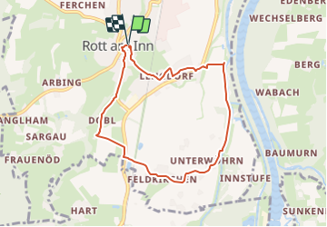
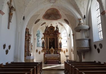
Percorso A piedi di 7,2 km da scoprire a Baviera, Landkreis Rosenheim, Rott am Inn. Questo percorso è proposto da SityTrail - itinéraires balisés pédestres.
Descrizione
Symbol: Baum (Silberweide) auf grünem Schild mit den Schriftzug "Innauenweg"
Localizzazione
Paese:
Germany
Regione :
Baviera
Dipartimento/Provincia :
Landkreis Rosenheim
Comune :
Rott am Inn
Località :
Unknown
Partenza:(Dec)
Partenza:(UTM)
285835 ; 5318382 (33T) N.
Commenti
Percorsi nelle vicinanze
![Percorso A piedi Prien am Chiemsee - Priener Postkartenweg - Photo](https://media.geolcdn.com/t/375/260/ext.jpg?maxdim=2&url=https%3A%2F%2Fmedia.geolcdn.com%2Ff%2Fe02e5267-41a2-46b2-a4c0-10b7a412546e.jpeg)
![A piedi A piedi](https://static1.geolcdn.com/sitytour/trail-icons/100.png)
Priener Postkartenweg
A piedi
Facile
Prien am Chiemsee,
Baviera,
Landkreis Rosenheim,
Germany
![](/images/other/stat-length.png)
4,8 km | 6 km-effort
1h 22min
![](https://static1.geolcdn.com/siteimages/upload/files/16400158638029165_repeat_loop_refresh_sync_direction_icon.png)
No
![Percorso A piedi Prien am Chiemsee - Rundweg 2 - Photo](https://media.geolcdn.com/t/375/260/ext.jpg?maxdim=2&url=https%3A%2F%2Fmedia.geolcdn.com%2Ff%2Fe02e5267-41a2-46b2-a4c0-10b7a412546e.jpeg)
![A piedi A piedi](https://static1.geolcdn.com/sitytour/trail-icons/100.png)
Rundweg 2
A piedi
Facile
Prien am Chiemsee,
Baviera,
Landkreis Rosenheim,
Germany
![](/images/other/stat-length.png)
7,3 km | 9,3 km-effort
2h 6min
![](https://static1.geolcdn.com/siteimages/upload/files/16400158638029165_repeat_loop_refresh_sync_direction_icon.png)
Sì
![Percorso A piedi Frasdorf - Pfaffinger-Runde - Photo](https://media.geolcdn.com/t/375/260/ext.jpg?maxdim=2&url=https%3A%2F%2Fmedia.geolcdn.com%2Ff%2Fa5698fd7-ec09-415c-8c68-e6c9afe0a1f0.jpeg)
![A piedi A piedi](https://static1.geolcdn.com/sitytour/trail-icons/100.png)
Pfaffinger-Runde
A piedi
Facile
Frasdorf,
Baviera,
Landkreis Rosenheim,
Germany
![](/images/other/stat-length.png)
5,3 km | 7 km-effort
1h 35min
![](https://static1.geolcdn.com/siteimages/upload/files/16400158638029165_repeat_loop_refresh_sync_direction_icon.png)
Sì
![Percorso A piedi Frasdorf - Geigeralm-Runde - Photo](https://media.geolcdn.com/t/375/260/ext.jpg?maxdim=2&url=https%3A%2F%2Fmedia.geolcdn.com%2Ff%2F6cc2e3eb-14b7-4d09-ac1d-1bfd502e327d.jpeg)
![A piedi A piedi](https://static1.geolcdn.com/sitytour/trail-icons/100.png)
Geigeralm-Runde
A piedi
Facile
Frasdorf,
Baviera,
Landkreis Rosenheim,
Germany
![](/images/other/stat-length.png)
4,3 km | 5,6 km-effort
1h 16min
![](https://static1.geolcdn.com/siteimages/upload/files/16400158638029165_repeat_loop_refresh_sync_direction_icon.png)
Sì
![Percorso A piedi Frasdorf - Herzogweg - Photo](https://media.geolcdn.com/t/375/260/ext.jpg?maxdim=2&url=https%3A%2F%2Fmedia.geolcdn.com%2Ff%2F9b520f38-837e-4f82-bec5-3443748c6377.jpeg)
![A piedi A piedi](https://static1.geolcdn.com/sitytour/trail-icons/100.png)
Herzogweg
A piedi
Facile
Frasdorf,
Baviera,
Landkreis Rosenheim,
Germany
![](/images/other/stat-length.png)
4,1 km | 5,2 km-effort
1h 10min
![](https://static1.geolcdn.com/siteimages/upload/files/16400158638029165_repeat_loop_refresh_sync_direction_icon.png)
No
![Percorso A piedi Frasdorf - St. Florians-Runde - Photo](https://media.geolcdn.com/t/375/260/ext.jpg?maxdim=2&url=https%3A%2F%2Fmedia.geolcdn.com%2Ff%2F51fd970b-0a7a-4cb5-a278-c7660f303ba5.jpeg)
![A piedi A piedi](https://static1.geolcdn.com/sitytour/trail-icons/100.png)
St. Florians-Runde
A piedi
Facile
Frasdorf,
Baviera,
Landkreis Rosenheim,
Germany
![](/images/other/stat-length.png)
6,1 km | 7,7 km-effort
1h 45min
![](https://static1.geolcdn.com/siteimages/upload/files/16400158638029165_repeat_loop_refresh_sync_direction_icon.png)
Sì
![Percorso A piedi Frasdorf - Wildenwarter-Runde - Photo](https://media.geolcdn.com/t/375/260/ext.jpg?maxdim=2&url=https%3A%2F%2Fmedia.geolcdn.com%2Ff%2F84a2d114-d2df-497f-a9c6-189f656ef06e.jpeg)
![A piedi A piedi](https://static1.geolcdn.com/sitytour/trail-icons/100.png)
Wildenwarter-Runde
A piedi
Facile
Frasdorf,
Baviera,
Landkreis Rosenheim,
Germany
![](/images/other/stat-length.png)
10,3 km | 12,7 km-effort
2h 53min
![](https://static1.geolcdn.com/siteimages/upload/files/16400158638029165_repeat_loop_refresh_sync_direction_icon.png)
Sì
![Percorso A piedi Stephanskirchen - Rundweg Baierbach - Photo](https://media.geolcdn.com/t/375/260/ext.jpg?maxdim=2&url=https%3A%2F%2Fmedia.geolcdn.com%2Ff%2F4cf59dd4-0d6b-4538-86ef-08ba42693677.jpeg)
![A piedi A piedi](https://static1.geolcdn.com/sitytour/trail-icons/100.png)
Rundweg Baierbach
A piedi
Facile
Stephanskirchen,
Baviera,
Landkreis Rosenheim,
Germany
![](/images/other/stat-length.png)
3,6 km | 4,1 km-effort
55min
![](https://static1.geolcdn.com/siteimages/upload/files/16400158638029165_repeat_loop_refresh_sync_direction_icon.png)
Sì
![Percorso A piedi Weyarn - Seerundweg - Photo](https://media.geolcdn.com/t/375/260/ext.jpg?maxdim=2&url=https%3A%2F%2Fmedia.geolcdn.com%2Ff%2Fbdfac741-40a5-4396-9cb0-e3a71327328a.jpeg)
![A piedi A piedi](https://static1.geolcdn.com/sitytour/trail-icons/100.png)
Seerundweg
A piedi
Facile
Weyarn,
Baviera,
Landkreis Miesbach,
Germany
![](/images/other/stat-length.png)
6,3 km | 7,2 km-effort
1h 37min
![](https://static1.geolcdn.com/siteimages/upload/files/16400158638029165_repeat_loop_refresh_sync_direction_icon.png)
Sì