


21 km | 30 km-effort

Tous les sentiers balisés d’Europe GUIDE+


Applicazione GPS da escursionismo GRATUITA
 SityTrail
IGN / Istituti geografici
SityTrail World
Il mondo è tuo
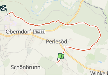
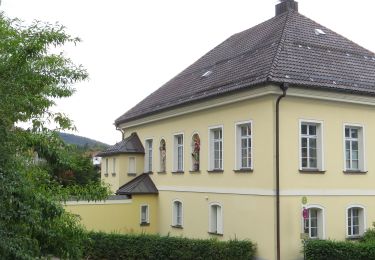
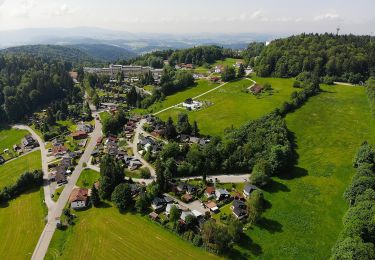
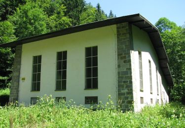
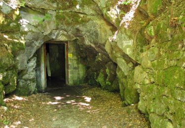
Percorso A piedi di 3,6 km da scoprire a Baviera, Landkreis Freyung-Grafenau, Freyung. Questo percorso è proposto da SityTrail - itinéraires balisés pédestres.
Trail created by Bayerischer Waldverein.
Symbol: Weiße 8 auf rotem Kreis
 "
data-pinterest-text="Pin it"
data-tweet-text="share on twitter"
data-facebook-share-url="https://www.sitytrail.com/it/trails/3092283-freyung--rundwanderweg-nrx-8-xperlesod-x-leitenholz-xkutzxx/?photo=1#lg=1&slide=1"
data-twitter-share-url="https://www.sitytrail.com/it/trails/3092283-freyung--rundwanderweg-nrx-8-xperlesod-x-leitenholz-xkutzxx/?photo=1#lg=1&slide=1"
data-googleplus-share-url="https://www.sitytrail.com/it/trails/3092283-freyung--rundwanderweg-nrx-8-xperlesod-x-leitenholz-xkutzxx/?photo=1#lg=1&slide=1"
data-pinterest-share-url="https://www.sitytrail.com/it/trails/3092283-freyung--rundwanderweg-nrx-8-xperlesod-x-leitenholz-xkutzxx/?photo=1#lg=1&slide=1">
"
data-pinterest-text="Pin it"
data-tweet-text="share on twitter"
data-facebook-share-url="https://www.sitytrail.com/it/trails/3092283-freyung--rundwanderweg-nrx-8-xperlesod-x-leitenholz-xkutzxx/?photo=1#lg=1&slide=1"
data-twitter-share-url="https://www.sitytrail.com/it/trails/3092283-freyung--rundwanderweg-nrx-8-xperlesod-x-leitenholz-xkutzxx/?photo=1#lg=1&slide=1"
data-googleplus-share-url="https://www.sitytrail.com/it/trails/3092283-freyung--rundwanderweg-nrx-8-xperlesod-x-leitenholz-xkutzxx/?photo=1#lg=1&slide=1"
data-pinterest-share-url="https://www.sitytrail.com/it/trails/3092283-freyung--rundwanderweg-nrx-8-xperlesod-x-leitenholz-xkutzxx/?photo=1#lg=1&slide=1">
 "
data-pinterest-text="Pin it"
data-tweet-text="share on twitter"
data-facebook-share-url="https://www.sitytrail.com/it/trails/3092283-freyung--rundwanderweg-nrx-8-xperlesod-x-leitenholz-xkutzxx/?photo=2#lg=1&slide=2"
data-twitter-share-url="https://www.sitytrail.com/it/trails/3092283-freyung--rundwanderweg-nrx-8-xperlesod-x-leitenholz-xkutzxx/?photo=2#lg=1&slide=2"
data-googleplus-share-url="https://www.sitytrail.com/it/trails/3092283-freyung--rundwanderweg-nrx-8-xperlesod-x-leitenholz-xkutzxx/?photo=2#lg=1&slide=2"
data-pinterest-share-url="https://www.sitytrail.com/it/trails/3092283-freyung--rundwanderweg-nrx-8-xperlesod-x-leitenholz-xkutzxx/?photo=2#lg=1&slide=2">
"
data-pinterest-text="Pin it"
data-tweet-text="share on twitter"
data-facebook-share-url="https://www.sitytrail.com/it/trails/3092283-freyung--rundwanderweg-nrx-8-xperlesod-x-leitenholz-xkutzxx/?photo=2#lg=1&slide=2"
data-twitter-share-url="https://www.sitytrail.com/it/trails/3092283-freyung--rundwanderweg-nrx-8-xperlesod-x-leitenholz-xkutzxx/?photo=2#lg=1&slide=2"
data-googleplus-share-url="https://www.sitytrail.com/it/trails/3092283-freyung--rundwanderweg-nrx-8-xperlesod-x-leitenholz-xkutzxx/?photo=2#lg=1&slide=2"
data-pinterest-share-url="https://www.sitytrail.com/it/trails/3092283-freyung--rundwanderweg-nrx-8-xperlesod-x-leitenholz-xkutzxx/?photo=2#lg=1&slide=2">
 "
data-pinterest-text="Pin it"
data-tweet-text="share on twitter"
data-facebook-share-url="https://www.sitytrail.com/it/trails/3092283-freyung--rundwanderweg-nrx-8-xperlesod-x-leitenholz-xkutzxx/?photo=3#lg=1&slide=3"
data-twitter-share-url="https://www.sitytrail.com/it/trails/3092283-freyung--rundwanderweg-nrx-8-xperlesod-x-leitenholz-xkutzxx/?photo=3#lg=1&slide=3"
data-googleplus-share-url="https://www.sitytrail.com/it/trails/3092283-freyung--rundwanderweg-nrx-8-xperlesod-x-leitenholz-xkutzxx/?photo=3#lg=1&slide=3"
data-pinterest-share-url="https://www.sitytrail.com/it/trails/3092283-freyung--rundwanderweg-nrx-8-xperlesod-x-leitenholz-xkutzxx/?photo=3#lg=1&slide=3">
"
data-pinterest-text="Pin it"
data-tweet-text="share on twitter"
data-facebook-share-url="https://www.sitytrail.com/it/trails/3092283-freyung--rundwanderweg-nrx-8-xperlesod-x-leitenholz-xkutzxx/?photo=3#lg=1&slide=3"
data-twitter-share-url="https://www.sitytrail.com/it/trails/3092283-freyung--rundwanderweg-nrx-8-xperlesod-x-leitenholz-xkutzxx/?photo=3#lg=1&slide=3"
data-googleplus-share-url="https://www.sitytrail.com/it/trails/3092283-freyung--rundwanderweg-nrx-8-xperlesod-x-leitenholz-xkutzxx/?photo=3#lg=1&slide=3"
data-pinterest-share-url="https://www.sitytrail.com/it/trails/3092283-freyung--rundwanderweg-nrx-8-xperlesod-x-leitenholz-xkutzxx/?photo=3#lg=1&slide=3">
 "
data-pinterest-text="Pin it"
data-tweet-text="share on twitter"
data-facebook-share-url="https://www.sitytrail.com/it/trails/3092283-freyung--rundwanderweg-nrx-8-xperlesod-x-leitenholz-xkutzxx/?photo=4#lg=1&slide=4"
data-twitter-share-url="https://www.sitytrail.com/it/trails/3092283-freyung--rundwanderweg-nrx-8-xperlesod-x-leitenholz-xkutzxx/?photo=4#lg=1&slide=4"
data-googleplus-share-url="https://www.sitytrail.com/it/trails/3092283-freyung--rundwanderweg-nrx-8-xperlesod-x-leitenholz-xkutzxx/?photo=4#lg=1&slide=4"
data-pinterest-share-url="https://www.sitytrail.com/it/trails/3092283-freyung--rundwanderweg-nrx-8-xperlesod-x-leitenholz-xkutzxx/?photo=4#lg=1&slide=4">
"
data-pinterest-text="Pin it"
data-tweet-text="share on twitter"
data-facebook-share-url="https://www.sitytrail.com/it/trails/3092283-freyung--rundwanderweg-nrx-8-xperlesod-x-leitenholz-xkutzxx/?photo=4#lg=1&slide=4"
data-twitter-share-url="https://www.sitytrail.com/it/trails/3092283-freyung--rundwanderweg-nrx-8-xperlesod-x-leitenholz-xkutzxx/?photo=4#lg=1&slide=4"
data-googleplus-share-url="https://www.sitytrail.com/it/trails/3092283-freyung--rundwanderweg-nrx-8-xperlesod-x-leitenholz-xkutzxx/?photo=4#lg=1&slide=4"
data-pinterest-share-url="https://www.sitytrail.com/it/trails/3092283-freyung--rundwanderweg-nrx-8-xperlesod-x-leitenholz-xkutzxx/?photo=4#lg=1&slide=4">
 "
data-pinterest-text="Pin it"
data-tweet-text="share on twitter"
data-facebook-share-url="https://www.sitytrail.com/it/trails/3092283-freyung--rundwanderweg-nrx-8-xperlesod-x-leitenholz-xkutzxx/?photo=5#lg=1&slide=5"
data-twitter-share-url="https://www.sitytrail.com/it/trails/3092283-freyung--rundwanderweg-nrx-8-xperlesod-x-leitenholz-xkutzxx/?photo=5#lg=1&slide=5"
data-googleplus-share-url="https://www.sitytrail.com/it/trails/3092283-freyung--rundwanderweg-nrx-8-xperlesod-x-leitenholz-xkutzxx/?photo=5#lg=1&slide=5"
data-pinterest-share-url="https://www.sitytrail.com/it/trails/3092283-freyung--rundwanderweg-nrx-8-xperlesod-x-leitenholz-xkutzxx/?photo=5#lg=1&slide=5">
"
data-pinterest-text="Pin it"
data-tweet-text="share on twitter"
data-facebook-share-url="https://www.sitytrail.com/it/trails/3092283-freyung--rundwanderweg-nrx-8-xperlesod-x-leitenholz-xkutzxx/?photo=5#lg=1&slide=5"
data-twitter-share-url="https://www.sitytrail.com/it/trails/3092283-freyung--rundwanderweg-nrx-8-xperlesod-x-leitenholz-xkutzxx/?photo=5#lg=1&slide=5"
data-googleplus-share-url="https://www.sitytrail.com/it/trails/3092283-freyung--rundwanderweg-nrx-8-xperlesod-x-leitenholz-xkutzxx/?photo=5#lg=1&slide=5"
data-pinterest-share-url="https://www.sitytrail.com/it/trails/3092283-freyung--rundwanderweg-nrx-8-xperlesod-x-leitenholz-xkutzxx/?photo=5#lg=1&slide=5">

A piedi
A piedi
A piedi
A piedi
A piedi
A piedi
A piedi
A piedi
A piedi