![](/images/other/stat-length.png)
![Percorso A piedi Pfreimd - Wanderroute Pfeimd/Sportplatz - Stein - Photo](https://media.geolcdn.com/t/1900/400/5d54c03a-c3e3-4aba-82bd-40d718b080fe.jpeg&format=pjpeg&maxdim=2)
Wanderroute Pfeimd/Sportplatz - Stein
SityTrail - itinéraires balisés pédestres
Tous les sentiers balisés d’Europe GUIDE+
![Lunghezza](/images/other/stat-length.png)
Lunghezza
5,2 km
![Altitudine massima](https://static1.geolcdn.com/siteimages/upload/files/1508320355ic_sort_altitude_max_24dp.png)
Altitudine massima
411 m
![Dislivello positivo](https://static1.geolcdn.com/siteimages/upload/files/1508320355ic_sort_den_pos_24dp.png)
Dislivello positivo
64 m
![Km-Effort](/images/other/stat-length.png)
Km-Effort
6,1 km
![Altitudine minima](https://static1.geolcdn.com/siteimages/upload/files/1508320355ic_sort_altitude_min_24dp.png)
Altitudine minima
371 m
![Dislivello negativo](https://static1.geolcdn.com/siteimages/upload/files/1508320355ic_sort_den_neg_24dp.png)
Dislivello negativo
75 m
![Boucle](https://static1.geolcdn.com/siteimages/upload/files/16400158638029165_repeat_loop_refresh_sync_direction_icon.png)
Boucle
No
Tag
Data di creazione :
2022-02-11 14:03:50.647
Ultima modifica :
2022-02-11 14:03:50.647
![A piedi](https://static1.geolcdn.com/sitytour/trail-icons/100.png)
1h22
Difficoltà : Facile
![Scannerizza questo codice QR per aprire il percorso nell'applicazione SityTrail](https://capi.geolives.com/qq0zvz2zws4bq2lad0pu/sitytour/trails/3091852/qr.png?size=200)
Applicazione GPS da escursionismo GRATUITA
Chi siamo
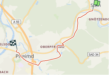
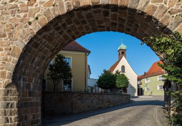
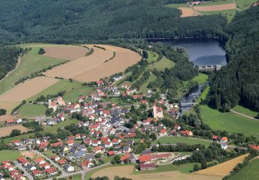
Percorso A piedi di 5,2 km da scoprire a Baviera, Landkreis Schwandorf, Pfreimd. Questo percorso è proposto da SityTrail - itinéraires balisés pédestres.
Descrizione
Trail created by Oberpfälzer Waldverein.
Symbol: rote Kreisscheibe
Sito web: https://www.owv-pfreimd.de/wanderwege.php
Localizzazione
Paese:
Germany
Regione :
Baviera
Dipartimento/Provincia :
Landkreis Schwandorf
Comune :
Pfreimd
Località :
Unknown
Partenza:(Dec)
Partenza:(UTM)
298997 ; 5487959 (33U) N.
Commenti
Percorsi nelle vicinanze
![Percorso A piedi Trausnitz - Trausnitz - Rabenleite - Photo](https://media.geolcdn.com/t/375/260/0b4758c0-a7e6-480f-8d5f-22de613c2429.jpeg&format=jpg&maxdim=2)
![A piedi A piedi](https://static1.geolcdn.com/sitytour/trail-icons/100.png)
Trausnitz - Rabenleite
A piedi
Facile
Trausnitz,
Baviera,
Landkreis Schwandorf,
Germany
![](/images/other/stat-length.png)
6,5 km | 9,5 km-effort
2h 9min
![](https://static1.geolcdn.com/siteimages/upload/files/16400158638029165_repeat_loop_refresh_sync_direction_icon.png)
No
![Percorso A piedi Wernberg-Köblitz - Landgrafenweg - Photo](https://media.geolcdn.com/t/375/260/3e7ad696-1a89-4e13-865d-ecfe842c33fc.jpeg&format=jpg&maxdim=2)
![A piedi A piedi](https://static1.geolcdn.com/sitytour/trail-icons/100.png)
Landgrafenweg
A piedi
Facile
Wernberg-Köblitz,
Baviera,
Landkreis Schwandorf,
Germany
![](/images/other/stat-length.png)
14,4 km | 19,4 km-effort
4h 24min
![](https://static1.geolcdn.com/siteimages/upload/files/16400158638029165_repeat_loop_refresh_sync_direction_icon.png)
No
![Percorso A piedi Wernberg-Köblitz - Wanderroute Lindacher Weg - Photo](https://media.geolcdn.com/t/375/260/dea6cde2-e0f4-4166-ae38-14448b38a674.jpeg&format=jpg&maxdim=2)
![A piedi A piedi](https://static1.geolcdn.com/sitytour/trail-icons/100.png)
Wanderroute Lindacher Weg
A piedi
Facile
Wernberg-Köblitz,
Baviera,
Landkreis Schwandorf,
Germany
![](/images/other/stat-length.png)
3,5 km | 4,7 km-effort
1h 3min
![](https://static1.geolcdn.com/siteimages/upload/files/16400158638029165_repeat_loop_refresh_sync_direction_icon.png)
No
![Percorso A piedi Trausnitz - Wanderroute Pfreimd/Sportplatz-SAD 32-Trausnitz - Photo](https://media.geolcdn.com/t/375/260/0b4758c0-a7e6-480f-8d5f-22de613c2429.jpeg&format=jpg&maxdim=2)
![A piedi A piedi](https://static1.geolcdn.com/sitytour/trail-icons/100.png)
Wanderroute Pfreimd/Sportplatz-SAD 32-Trausnitz
A piedi
Facile
Trausnitz,
Baviera,
Landkreis Schwandorf,
Germany
![](/images/other/stat-length.png)
5,3 km | 7,1 km-effort
1h 36min
![](https://static1.geolcdn.com/siteimages/upload/files/16400158638029165_repeat_loop_refresh_sync_direction_icon.png)
No
![Percorso A piedi Nabburg - Hallerdenkmal - Photo](https://media.geolcdn.com/t/375/260/4f006f09-e789-428a-a760-6529a2248b19.jpeg&format=jpg&maxdim=2)
![A piedi A piedi](https://static1.geolcdn.com/sitytour/trail-icons/100.png)
Hallerdenkmal
A piedi
Facile
Nabburg,
Baviera,
Landkreis Schwandorf,
Germany
![](/images/other/stat-length.png)
6,4 km | 8,4 km-effort
1h 54min
![](https://static1.geolcdn.com/siteimages/upload/files/16400158638029165_repeat_loop_refresh_sync_direction_icon.png)
Sì
![Percorso A piedi Nabburg - Wiesensüß-Rundwanderweg - Photo](https://media.geolcdn.com/t/375/260/33b83e02-554a-4c32-9f6d-bb992195cc6b.jpeg&format=jpg&maxdim=2)
![A piedi A piedi](https://static1.geolcdn.com/sitytour/trail-icons/100.png)
Wiesensüß-Rundwanderweg
A piedi
Facile
Nabburg,
Baviera,
Landkreis Schwandorf,
Germany
![](/images/other/stat-length.png)
6,6 km | 8,4 km-effort
1h 54min
![](https://static1.geolcdn.com/siteimages/upload/files/16400158638029165_repeat_loop_refresh_sync_direction_icon.png)
No
![Percorso A piedi Wernberg-Köblitz - Wanderroute Eixelbergweg - Photo](https://media.geolcdn.com/t/375/260/4f006f09-e789-428a-a760-6529a2248b19.jpeg&format=jpg&maxdim=2)
![A piedi A piedi](https://static1.geolcdn.com/sitytour/trail-icons/100.png)
Wanderroute Eixelbergweg
A piedi
Facile
Wernberg-Köblitz,
Baviera,
Landkreis Schwandorf,
Germany
![](/images/other/stat-length.png)
13,1 km | 18,2 km-effort
4h 8min
![](https://static1.geolcdn.com/siteimages/upload/files/16400158638029165_repeat_loop_refresh_sync_direction_icon.png)
No
![Percorso A piedi Tännesberg - Pfreimdtal Uferpfad - Photo](https://media.geolcdn.com/t/375/260/0b4758c0-a7e6-480f-8d5f-22de613c2429.jpeg&format=jpg&maxdim=2)
![A piedi A piedi](https://static1.geolcdn.com/sitytour/trail-icons/100.png)
Pfreimdtal Uferpfad
A piedi
Facile
Tännesberg,
Baviera,
Landkreis Neustadt an der Waldnaab,
Germany
![](/images/other/stat-length.png)
12,3 km | 16,2 km-effort
3h 40min
![](https://static1.geolcdn.com/siteimages/upload/files/16400158638029165_repeat_loop_refresh_sync_direction_icon.png)
Sì
![Percorso A piedi Pfreimd - Trausnitz-Stein-Hohentreßwitz - Photo](https://media.geolcdn.com/t/375/260/049068ef-ccdd-4dca-bc72-ad8d6837344b.jpeg&format=jpg&maxdim=2)
![A piedi A piedi](https://static1.geolcdn.com/sitytour/trail-icons/100.png)
Trausnitz-Stein-Hohentreßwitz
A piedi
Facile
Pfreimd,
Baviera,
Landkreis Schwandorf,
Germany
![](/images/other/stat-length.png)
10,8 km | 14,9 km-effort
3h 23min
![](https://static1.geolcdn.com/siteimages/upload/files/16400158638029165_repeat_loop_refresh_sync_direction_icon.png)
Sì