![](/images/other/stat-length.png)
![Percorso A piedi Langerwehe - Langerwehe Wanderrundweg Nr. 31 - Photo](https://media.geolcdn.com/t/1900/400/404422ff-d695-461b-8392-02729ac5736e.jpeg&format=pjpeg&maxdim=2)
Langerwehe Wanderrundweg Nr. 31
SityTrail - itinéraires balisés pédestres
Tous les sentiers balisés d’Europe GUIDE+
![Lunghezza](/images/other/stat-length.png)
Lunghezza
7,2 km
![Altitudine massima](https://static1.geolcdn.com/siteimages/upload/files/1508320355ic_sort_altitude_max_24dp.png)
Altitudine massima
220 m
![Dislivello positivo](https://static1.geolcdn.com/siteimages/upload/files/1508320355ic_sort_den_pos_24dp.png)
Dislivello positivo
149 m
![Km-Effort](/images/other/stat-length.png)
Km-Effort
9,2 km
![Altitudine minima](https://static1.geolcdn.com/siteimages/upload/files/1508320355ic_sort_altitude_min_24dp.png)
Altitudine minima
136 m
![Dislivello negativo](https://static1.geolcdn.com/siteimages/upload/files/1508320355ic_sort_den_neg_24dp.png)
Dislivello negativo
148 m
![Boucle](https://static1.geolcdn.com/siteimages/upload/files/16400158638029165_repeat_loop_refresh_sync_direction_icon.png)
Boucle
Sì
Tag
Data di creazione :
2022-02-11 13:16:06.535
Ultima modifica :
2022-02-11 13:16:06.535
![A piedi](https://static1.geolcdn.com/sitytour/trail-icons/100.png)
2h05
Difficoltà : Facile
![Scannerizza questo codice QR per aprire il percorso nell'applicazione SityTrail](https://capi.geolives.com/qq0zvz2zws4bq2lad0pu/sitytour/trails/3089759/qr.png?size=200)
Applicazione GPS da escursionismo GRATUITA
Chi siamo
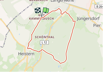
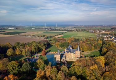
Percorso A piedi di 7,2 km da scoprire a Renania Settentrionale-Vestfalia, Kreis Düren, Langerwehe. Questo percorso è proposto da SityTrail - itinéraires balisés pédestres.
Descrizione
Trail created by Eifelverein.
Wegeführung vor/im Bereich Heistern prüfen
Symbol: schwarze 31 auf weißem Grund
Localizzazione
Paese:
Germany
Regione :
Renania Settentrionale-Vestfalia
Dipartimento/Provincia :
Kreis Düren
Comune :
Langerwehe
Località :
Unknown
Partenza:(Dec)
Partenza:(UTM)
313015 ; 5632195 (32U) N.
Commenti
Percorsi nelle vicinanze
![Percorso A piedi Stolberg - Schevenhütte Rundweg 3 - Photo](https://media.geolcdn.com/t/375/260/0d483f44-9c9c-432f-a23e-3b9f818f413c.jpeg&format=jpg&maxdim=2)
![A piedi A piedi](https://static1.geolcdn.com/sitytour/trail-icons/100.png)
Schevenhütte Rundweg 3
A piedi
Facile
Stolberg,
Renania Settentrionale-Vestfalia,
Städteregion Aachen,
Germany
![](/images/other/stat-length.png)
6,9 km | 9 km-effort
2h 3min
![](https://static1.geolcdn.com/siteimages/upload/files/16400158638029165_repeat_loop_refresh_sync_direction_icon.png)
No
![Percorso A piedi Langerwehe - Schlich Rundweg 71 - Photo](https://media.geolcdn.com/t/375/260/466cb838-894a-4cc5-b608-7394d42b1dd5.jpeg&format=jpg&maxdim=2)
![A piedi A piedi](https://static1.geolcdn.com/sitytour/trail-icons/100.png)
Schlich Rundweg 71
A piedi
Facile
Langerwehe,
Renania Settentrionale-Vestfalia,
Kreis Düren,
Germany
![](/images/other/stat-length.png)
9,2 km | 12 km-effort
2h 43min
![](https://static1.geolcdn.com/siteimages/upload/files/16400158638029165_repeat_loop_refresh_sync_direction_icon.png)
Sì
![Percorso A piedi Langerwehe - Langerwehe Wanderrundweg Nr. 11 - Photo](https://media.geolcdn.com/t/375/260/69b405e1-5955-4ecf-a90c-332b2358c798.jpeg&format=jpg&maxdim=2)
![A piedi A piedi](https://static1.geolcdn.com/sitytour/trail-icons/100.png)
Langerwehe Wanderrundweg Nr. 11
A piedi
Facile
Langerwehe,
Renania Settentrionale-Vestfalia,
Kreis Düren,
Germany
![](/images/other/stat-length.png)
9,1 km | 11,1 km-effort
2h 31min
![](https://static1.geolcdn.com/siteimages/upload/files/16400158638029165_repeat_loop_refresh_sync_direction_icon.png)
Sì
![Percorso A piedi Stolberg - Langerwehe Rundwanderweg Nr. 41 - Photo](https://media.geolcdn.com/t/375/260/885b2889-e761-44ac-8069-32698e7e51e2.jpeg&format=jpg&maxdim=2)
![A piedi A piedi](https://static1.geolcdn.com/sitytour/trail-icons/100.png)
Langerwehe Rundwanderweg Nr. 41
A piedi
Facile
Stolberg,
Renania Settentrionale-Vestfalia,
Städteregion Aachen,
Germany
![](/images/other/stat-length.png)
12,2 km | 15,1 km-effort
3h 26min
![](https://static1.geolcdn.com/siteimages/upload/files/16400158638029165_repeat_loop_refresh_sync_direction_icon.png)
Sì
![Percorso A piedi Langerwehe - Langerwehe Wanderrundweg Nr. 21 - Photo](https://media.geolcdn.com/t/375/260/c7aca381-6f62-4196-b548-181d0a19cba5.jpeg&format=jpg&maxdim=2)
![A piedi A piedi](https://static1.geolcdn.com/sitytour/trail-icons/100.png)
Langerwehe Wanderrundweg Nr. 21
A piedi
Facile
Langerwehe,
Renania Settentrionale-Vestfalia,
Kreis Düren,
Germany
![](/images/other/stat-length.png)
9,6 km | 12,6 km-effort
2h 52min
![](https://static1.geolcdn.com/siteimages/upload/files/16400158638029165_repeat_loop_refresh_sync_direction_icon.png)
No
![Percorso A piedi Langerwehe - Schlich Rundweg 61 - Photo](https://media.geolcdn.com/t/375/260/aff25654-5f90-4498-ab70-279cf19c150e.jpeg&format=jpg&maxdim=2)
![A piedi A piedi](https://static1.geolcdn.com/sitytour/trail-icons/100.png)
Schlich Rundweg 61
A piedi
Facile
Langerwehe,
Renania Settentrionale-Vestfalia,
Kreis Düren,
Germany
![](/images/other/stat-length.png)
4 km | 4,7 km-effort
1h 3min
![](https://static1.geolcdn.com/siteimages/upload/files/16400158638029165_repeat_loop_refresh_sync_direction_icon.png)
No
![Percorso A piedi Langerwehe - Schlich Rundweg 51 - Photo](https://media.geolcdn.com/t/375/260/08a24b01-298f-4f55-88d1-0767e694a52a.jpeg&format=jpg&maxdim=2)
![A piedi A piedi](https://static1.geolcdn.com/sitytour/trail-icons/100.png)
Schlich Rundweg 51
A piedi
Facile
Langerwehe,
Renania Settentrionale-Vestfalia,
Kreis Düren,
Germany
![](/images/other/stat-length.png)
7 km | 8,8 km-effort
1h 59min
![](https://static1.geolcdn.com/siteimages/upload/files/16400158638029165_repeat_loop_refresh_sync_direction_icon.png)
Sì
![Percorso A piedi Eschweiler - Heimatkundlicher Rundwanderweg Eschweiler - Photo](https://media.geolcdn.com/t/375/260/9ec98c1c-540f-417c-86ee-b41a9eee9424.jpeg&format=jpg&maxdim=2)
![A piedi A piedi](https://static1.geolcdn.com/sitytour/trail-icons/100.png)
Heimatkundlicher Rundwanderweg Eschweiler
A piedi
Difficile
Eschweiler,
Renania Settentrionale-Vestfalia,
Städteregion Aachen,
Germany
![](/images/other/stat-length.png)
29 km | 35 km-effort
7h 53min
![](https://static1.geolcdn.com/siteimages/upload/files/16400158638029165_repeat_loop_refresh_sync_direction_icon.png)
No
![Percorso A piedi Eschweiler - Eschweiler Mühlenweg - Photo](https://media.geolcdn.com/t/375/260/794a0236-8c54-488b-a336-5fe19c410c34.jpeg&format=jpg&maxdim=2)
![A piedi A piedi](https://static1.geolcdn.com/sitytour/trail-icons/100.png)
Eschweiler Mühlenweg
A piedi
Facile
Eschweiler,
Renania Settentrionale-Vestfalia,
Städteregion Aachen,
Germany
![](/images/other/stat-length.png)
14,1 km | 16,2 km-effort
3h 41min
![](https://static1.geolcdn.com/siteimages/upload/files/16400158638029165_repeat_loop_refresh_sync_direction_icon.png)
Sì