![](/images/other/stat-length.png)
![Percorso A piedi Bad Soden-Salmünster - Gebietswanderweg: Salmünster => Marjoß - Photo](https://media.geolcdn.com/t/1900/400/8aacf1ce-ab6a-46e8-9d72-f71a2b1e38f1.jpeg&format=pjpeg&maxdim=2)
Gebietswanderweg: Salmünster => Marjoß
SityTrail - itinéraires balisés pédestres
Tous les sentiers balisés d’Europe GUIDE+
![Lunghezza](/images/other/stat-length.png)
![Altitudine massima](https://static1.geolcdn.com/siteimages/upload/files/1508320355ic_sort_altitude_max_24dp.png)
![Dislivello positivo](https://static1.geolcdn.com/siteimages/upload/files/1508320355ic_sort_den_pos_24dp.png)
![Km-Effort](/images/other/stat-length.png)
![Altitudine minima](https://static1.geolcdn.com/siteimages/upload/files/1508320355ic_sort_altitude_min_24dp.png)
![Dislivello negativo](https://static1.geolcdn.com/siteimages/upload/files/1508320355ic_sort_den_neg_24dp.png)
![Boucle](https://static1.geolcdn.com/siteimages/upload/files/16400158638029165_repeat_loop_refresh_sync_direction_icon.png)
![A piedi](https://static1.geolcdn.com/sitytour/trail-icons/100.png)
3h36
Difficoltà : Facile
![Scannerizza questo codice QR per aprire il percorso nell'applicazione SityTrail](https://capi.geolives.com/qq0zvz2zws4bq2lad0pu/sitytour/trails/3088773/qr.png?size=200)
Applicazione GPS da escursionismo GRATUITA
Chi siamo
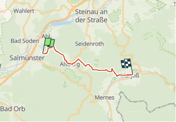
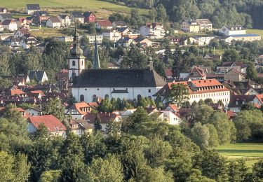
Percorso A piedi di 12,2 km da scoprire a Assia, Main-Kinzig-Kreis, Bad Soden-Salmünster. Questo percorso è proposto da SityTrail - itinéraires balisés pédestres.
Descrizione
Trail created by Spessartbund.
Der Wegeverlauf hat sich nach der Unstrukturierung geändert. Muß neu erfasst werden.
Symbol: Rotes X auf weißem Grund
Localizzazione
Commenti
Percorsi nelle vicinanze
![Percorso A piedi Bad Soden-Salmünster - Spessartspuren - Bad Sodener Waldgeflüster - Photo](https://media.geolcdn.com/t/375/260/eab33703-db53-400c-8f5e-a96553cdf665.jpeg&format=jpg&maxdim=2)
![A piedi A piedi](https://static1.geolcdn.com/sitytour/trail-icons/100.png)
A piedi
![](/images/other/stat-length.png)
![](https://static1.geolcdn.com/siteimages/upload/files/16400158638029165_repeat_loop_refresh_sync_direction_icon.png)
![Percorso A piedi Bad Soden-Salmünster - Stolzenberger Ritterblick ( Spessartfährten ) - Photo](https://media.geolcdn.com/t/375/260/082b6977-d9de-4d85-b235-3038f01e708d.jpeg&format=jpg&maxdim=2)
![A piedi A piedi](https://static1.geolcdn.com/sitytour/trail-icons/100.png)
A piedi
![](/images/other/stat-length.png)
![](https://static1.geolcdn.com/siteimages/upload/files/16400158638029165_repeat_loop_refresh_sync_direction_icon.png)
![Percorso A piedi Steinau an der Straße - Steinau a. d. Straße, Wanderweg 3b - Photo](https://media.geolcdn.com/t/375/260/a727d70d-c791-4517-b7dc-042b076b4739.jpeg&format=jpg&maxdim=2)
![A piedi A piedi](https://static1.geolcdn.com/sitytour/trail-icons/100.png)
A piedi
![](/images/other/stat-length.png)
![](https://static1.geolcdn.com/siteimages/upload/files/16400158638029165_repeat_loop_refresh_sync_direction_icon.png)
![Percorso A piedi Steinau an der Straße - Steinau a.d. Straße - Wartenweg 1 - Photo](https://media.geolcdn.com/t/375/260/b8e05691-abbb-48d7-8d7c-199ee18beccd.jpeg&format=jpg&maxdim=2)
![A piedi A piedi](https://static1.geolcdn.com/sitytour/trail-icons/100.png)
A piedi
![](/images/other/stat-length.png)
![](https://static1.geolcdn.com/siteimages/upload/files/16400158638029165_repeat_loop_refresh_sync_direction_icon.png)
![Percorso A piedi Steinau an der Straße - Steinau a.d. Straße - Wartenweg 4 - Photo](https://media.geolcdn.com/t/375/260/b8e05691-abbb-48d7-8d7c-199ee18beccd.jpeg&format=jpg&maxdim=2)
![A piedi A piedi](https://static1.geolcdn.com/sitytour/trail-icons/100.png)
A piedi
![](/images/other/stat-length.png)
![](https://static1.geolcdn.com/siteimages/upload/files/16400158638029165_repeat_loop_refresh_sync_direction_icon.png)
![Percorso A piedi Steinau an der Straße - Steinau a. d. Straße, Wanderweg 5 - Photo](https://media.geolcdn.com/t/375/260/2f75ce78-7455-4a1f-a522-572d5daa3bf8.jpeg&format=jpg&maxdim=2)
![A piedi A piedi](https://static1.geolcdn.com/sitytour/trail-icons/100.png)
A piedi
![](/images/other/stat-length.png)
![](https://static1.geolcdn.com/siteimages/upload/files/16400158638029165_repeat_loop_refresh_sync_direction_icon.png)
![Percorso A piedi Steinau an der Straße - Steinau a. d. Straße, Wanderweg 4 - Photo](https://media.geolcdn.com/t/375/260/70e32bfd-28e0-42b4-b181-05d76eecec73.jpeg&format=jpg&maxdim=2)
![A piedi A piedi](https://static1.geolcdn.com/sitytour/trail-icons/100.png)
A piedi
![](/images/other/stat-length.png)
![](https://static1.geolcdn.com/siteimages/upload/files/16400158638029165_repeat_loop_refresh_sync_direction_icon.png)
![Percorso A piedi Steinau an der Straße - Steinau a. d. Straße, Wanderweg 4a - Photo](https://media.geolcdn.com/t/375/260/70e32bfd-28e0-42b4-b181-05d76eecec73.jpeg&format=jpg&maxdim=2)
![A piedi A piedi](https://static1.geolcdn.com/sitytour/trail-icons/100.png)
A piedi
![](/images/other/stat-length.png)
![](https://static1.geolcdn.com/siteimages/upload/files/16400158638029165_repeat_loop_refresh_sync_direction_icon.png)
![Percorso A piedi Bad Soden-Salmünster - Bad Soden-Salmünster Wanderweg Nr. 25 - Photo](https://media.geolcdn.com/t/375/260/b89c92df-7d0b-4e60-b4f6-ef31cde72362.jpeg&format=jpg&maxdim=2)
![A piedi A piedi](https://static1.geolcdn.com/sitytour/trail-icons/100.png)
A piedi
![](/images/other/stat-length.png)
![](https://static1.geolcdn.com/siteimages/upload/files/16400158638029165_repeat_loop_refresh_sync_direction_icon.png)