![](/images/other/stat-length.png)
![Percorso A piedi Schönbrunner Wald - Haselhuhn - Photo](https://media.geolcdn.com/t/1900/400/ext.pjpeg?maxdim=2&url=https%3A%2F%2Fstatic1.geolcdn.com%2Fsiteimages%2Fupload%2Ffiles%2F1545311037marcheuse_200dpi.jpg)
Haselhuhn
SityTrail - itinéraires balisés pédestres
Tous les sentiers balisés d’Europe GUIDE+
![Lunghezza](/images/other/stat-length.png)
Lunghezza
3,3 km
![Altitudine massima](https://static1.geolcdn.com/siteimages/upload/files/1508320355ic_sort_altitude_max_24dp.png)
Altitudine massima
1012 m
![Dislivello positivo](https://static1.geolcdn.com/siteimages/upload/files/1508320355ic_sort_den_pos_24dp.png)
Dislivello positivo
172 m
![Km-Effort](/images/other/stat-length.png)
Km-Effort
5,6 km
![Altitudine minima](https://static1.geolcdn.com/siteimages/upload/files/1508320355ic_sort_altitude_min_24dp.png)
Altitudine minima
836 m
![Dislivello negativo](https://static1.geolcdn.com/siteimages/upload/files/1508320355ic_sort_den_neg_24dp.png)
Dislivello negativo
176 m
![Boucle](https://static1.geolcdn.com/siteimages/upload/files/16400158638029165_repeat_loop_refresh_sync_direction_icon.png)
Boucle
Sì
Tag
Data di creazione :
2022-02-11 12:43:51.771
Ultima modifica :
2022-02-11 12:43:51.771
![A piedi](https://static1.geolcdn.com/sitytour/trail-icons/100.png)
1h15
Difficoltà : Facile
![Scannerizza questo codice QR per aprire il percorso nell'applicazione SityTrail](https://capi.geolives.com/qq0zvz2zws4bq2lad0pu/sitytour/trails/3087708/qr.png?size=200)
Applicazione GPS da escursionismo GRATUITA
Chi siamo
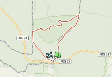
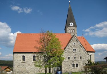
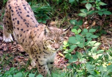
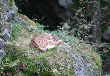
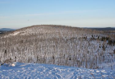
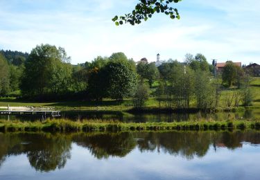
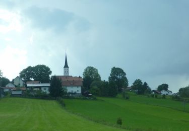
Percorso A piedi di 3,3 km da scoprire a Baviera, Landkreis Freyung-Grafenau, Schönbrunner Wald. Questo percorso è proposto da SityTrail - itinéraires balisés pédestres.
Descrizione
Trail created by Nationalpark Bayerischer Wald.
Symbol: Tiersymbol (Haselhuhn) in schwarz auf gelbem quadratischem Grund
Localizzazione
Paese:
Germany
Regione :
Baviera
Dipartimento/Provincia :
Landkreis Freyung-Grafenau
Comune :
Schönbrunner Wald
Località :
Unknown
Partenza:(Dec)
Partenza:(UTM)
392176 ; 5415154 (33U) N.
Commenti
Percorsi nelle vicinanze
![Percorso A piedi Neuschönau - Dachs - Photo](https://media.geolcdn.com/t/375/260/bd4d4b66-a4a1-483f-a98d-2833317cd1dc.jpeg&format=jpg&maxdim=2)
![A piedi A piedi](https://static1.geolcdn.com/sitytour/trail-icons/100.png)
Dachs
A piedi
Facile
Neuschönau,
Baviera,
Landkreis Freyung-Grafenau,
Germany
![](/images/other/stat-length.png)
4,5 km | 5,7 km-effort
1h 17min
![](https://static1.geolcdn.com/siteimages/upload/files/16400158638029165_repeat_loop_refresh_sync_direction_icon.png)
Sì
![Percorso A piedi Neuschönau - Haustaube - Photo](https://media.geolcdn.com/t/375/260/78aeb269-300f-4d79-aaf4-32920732cb70.jpeg&format=jpg&maxdim=2)
![A piedi A piedi](https://static1.geolcdn.com/sitytour/trail-icons/100.png)
Haustaube
A piedi
Facile
Neuschönau,
Baviera,
Landkreis Freyung-Grafenau,
Germany
![](/images/other/stat-length.png)
6,8 km | 9,5 km-effort
2h 8min
![](https://static1.geolcdn.com/siteimages/upload/files/16400158638029165_repeat_loop_refresh_sync_direction_icon.png)
Sì
![Percorso A piedi Neuschönau - Laubbaum - Photo](https://media.geolcdn.com/t/375/260/99fba781-b2ad-4f50-a612-eecb0bdb3442.jpeg&format=jpg&maxdim=2)
![A piedi A piedi](https://static1.geolcdn.com/sitytour/trail-icons/100.png)
Laubbaum
A piedi
Facile
Neuschönau,
Baviera,
Landkreis Freyung-Grafenau,
Germany
![](/images/other/stat-length.png)
4,7 km | 7,4 km-effort
1h 41min
![](https://static1.geolcdn.com/siteimages/upload/files/16400158638029165_repeat_loop_refresh_sync_direction_icon.png)
No
![Percorso A piedi Mauth - Schnecke (Rundweg Finsterau) - Photo](https://media.geolcdn.com/t/375/260/3a25b2fc-d75f-4ca3-aba2-7646b3467e09.jpeg&format=jpg&maxdim=2)
![A piedi A piedi](https://static1.geolcdn.com/sitytour/trail-icons/100.png)
Schnecke (Rundweg Finsterau)
A piedi
Facile
Mauth,
Baviera,
Landkreis Freyung-Grafenau,
Germany
![](/images/other/stat-length.png)
6,9 km | 9,3 km-effort
2h 6min
![](https://static1.geolcdn.com/siteimages/upload/files/16400158638029165_repeat_loop_refresh_sync_direction_icon.png)
No
![Percorso A piedi Neuschönau - Gehegerundweg - Photo](https://media.geolcdn.com/t/375/260/e5bc7dd2-73c0-46f6-9590-ed0b397c3f79.jpeg&format=jpg&maxdim=2)
![A piedi A piedi](https://static1.geolcdn.com/sitytour/trail-icons/100.png)
Gehegerundweg
A piedi
Facile
Neuschönau,
Baviera,
Landkreis Freyung-Grafenau,
Germany
![](/images/other/stat-length.png)
6,8 km | 8,9 km-effort
2h 1min
![](https://static1.geolcdn.com/siteimages/upload/files/16400158638029165_repeat_loop_refresh_sync_direction_icon.png)
Sì
![Percorso A piedi Mauth - Tanne - Photo](https://media.geolcdn.com/t/375/260/2c0d28a4-89ad-4c78-89b1-ff597fc887d5.jpeg&format=jpg&maxdim=2)
![A piedi A piedi](https://static1.geolcdn.com/sitytour/trail-icons/100.png)
Tanne
A piedi
Medio
Mauth,
Baviera,
Landkreis Freyung-Grafenau,
Germany
![](/images/other/stat-length.png)
13,8 km | 21 km-effort
4h 42min
![](https://static1.geolcdn.com/siteimages/upload/files/16400158638029165_repeat_loop_refresh_sync_direction_icon.png)
No
![Percorso A piedi Neuschönau - Rippenfarn - Photo](https://media.geolcdn.com/t/375/260/8c452737-ba5c-48cf-946c-b9516cf7a468.jpeg&format=jpg&maxdim=2)
![A piedi A piedi](https://static1.geolcdn.com/sitytour/trail-icons/100.png)
Rippenfarn
A piedi
Facile
Neuschönau,
Baviera,
Landkreis Freyung-Grafenau,
Germany
![](/images/other/stat-length.png)
8,6 km | 15,1 km-effort
3h 25min
![](https://static1.geolcdn.com/siteimages/upload/files/16400158638029165_repeat_loop_refresh_sync_direction_icon.png)
No
![Percorso A piedi Hohenau - Glockenblume - Photo](https://media.geolcdn.com/t/375/260/140bd1e8-fd53-4b79-adeb-9cd36b677bfe.jpeg&format=jpg&maxdim=2)
![A piedi A piedi](https://static1.geolcdn.com/sitytour/trail-icons/100.png)
Glockenblume
A piedi
Facile
Hohenau,
Baviera,
Landkreis Freyung-Grafenau,
Germany
![](/images/other/stat-length.png)
4,3 km | 6,4 km-effort
1h 27min
![](https://static1.geolcdn.com/siteimages/upload/files/16400158638029165_repeat_loop_refresh_sync_direction_icon.png)
No
![Percorso A piedi Freyung - Verlängerungsmöglichkeit zu Rundwanderweg Nr. 4 - Photo](https://media.geolcdn.com/t/375/260/28f15b54-fc8f-49a8-8d3c-abb30c65151f.jpeg&format=jpg&maxdim=2)
![A piedi A piedi](https://static1.geolcdn.com/sitytour/trail-icons/100.png)
Verlängerungsmöglichkeit zu Rundwanderweg Nr. 4
A piedi
Facile
Freyung,
Baviera,
Landkreis Freyung-Grafenau,
Germany
![](/images/other/stat-length.png)
4 km | 6 km-effort
1h 21min
![](https://static1.geolcdn.com/siteimages/upload/files/16400158638029165_repeat_loop_refresh_sync_direction_icon.png)
No