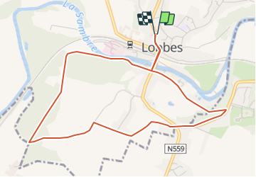
![](/images/other/stat-length.png)
![Percorso A piedi Lobbes - Promenade Héroïque - Photo](https://media.geolcdn.com/t/1900/400/ext.pjpeg?maxdim=2&url=https%3A%2F%2Fpivotmedia.tourismewallonie.be%2FOTH-A0-004A-2FG6%2FOTH-A0-004A-2FG6.jpg)
Promenade Héroïque
Commissariat général au Tourisme
Randonnées du CGT GUIDE+
![Lunghezza](/images/other/stat-length.png)
![Altitudine massima](https://static1.geolcdn.com/siteimages/upload/files/1508320355ic_sort_altitude_max_24dp.png)
![Dislivello positivo](https://static1.geolcdn.com/siteimages/upload/files/1508320355ic_sort_den_pos_24dp.png)
![Km-Effort](/images/other/stat-length.png)
![Altitudine minima](https://static1.geolcdn.com/siteimages/upload/files/1508320355ic_sort_altitude_min_24dp.png)
![Dislivello negativo](https://static1.geolcdn.com/siteimages/upload/files/1508320355ic_sort_den_neg_24dp.png)
![Boucle](https://static1.geolcdn.com/siteimages/upload/files/16400158638029165_repeat_loop_refresh_sync_direction_icon.png)
![A piedi](https://static1.geolcdn.com/sitytour/trail-icons/100.png)
1h24
Difficoltà : Facile
![Scannerizza questo codice QR per aprire il percorso nell'applicazione SityTrail](https://capi.geolives.com/qq0zvz2zws4bq2lad0pu/sitytour/trails/3081463/qr.png?size=200)
Applicazione GPS da escursionismo GRATUITA
Chi siamo
Percorso A piedi di 4,9 km da scoprire a Wallonie, Hainaut, Lobbes. Questo percorso è proposto da Commissariat général au Tourisme.
Descrizione
Trail created by Pays des Lacs.
On 23 August 1914, the French soldiers slowed the approach of the Germans. Despite the German’s greater numbers, the French army inflicted heavy losses on the enemy soldiers. In the evening, the cavalry corps withdrew to the south. The village was torched and the inhabitants cared for the injured and buried the bodies. The route leads you to discover the history of the First World War, the battle tactics, the organisation of treatment and the building of the French cemetery and its monuments erected in honour of the soldiers who died in combat.
Localizzazione
Commenti
Percorsi nelle vicinanze
![Percorso Marcia Fontaine-l'Évêque - de l'Abbaye d'Aulne au hameau de Hourpes - Thuin - Photo](https://media.geolcdn.com/t/375/260/a34a09f7-2ebf-4334-b3ab-6307c79b316f.jpeg&format=jpg&maxdim=2)
![Marcia Marcia](https://static1.geolcdn.com/sitytour/trail-icons/101.png)
Marcia
![](/images/other/stat-length.png)
![](https://static1.geolcdn.com/siteimages/upload/files/16400158638029165_repeat_loop_refresh_sync_direction_icon.png)
![Percorso Marcia Thuin - La balade du Bois des Waibes. - Photo](https://media.geolcdn.com/t/375/260/ext.jpg?maxdim=2&url=https%3A%2F%2Fservices.sitytrail.com%2FGeolivesWS%2FDownloadMedia.ashx%3FTrailID%3D846785%26Media%3D2a15c231-0cbe-4107-9b4e-b0ca15c25a1f.jpg)
![Marcia Marcia](https://static1.geolcdn.com/sitytour/trail-icons/101.png)
Marcia
![](/images/other/stat-length.png)
![](https://static1.geolcdn.com/siteimages/upload/files/16400158638029165_repeat_loop_refresh_sync_direction_icon.png)
![Percorso Marcia Lobbes - Balade à Mont-Sainte-Geneviève - Photo](https://media.geolcdn.com/t/375/260/ext.jpg?maxdim=2&url=https%3A%2F%2Fservices.sitytrail.com%2FGeolivesWS%2FDownloadMedia.ashx%3FTrailID%3D378767%26Media%3D9ad7b20e-c031-407f-875d-742351009cf4.jpg)
![Marcia Marcia](https://static1.geolcdn.com/sitytour/trail-icons/101.png)
Marcia
![](/images/other/stat-length.png)
![](https://static1.geolcdn.com/siteimages/upload/files/16400158638029165_repeat_loop_refresh_sync_direction_icon.png)
![Percorso Marcia Binche - Les marais de Buvrinnes - Photo](https://media.geolcdn.com/t/375/260/ext.jpg?maxdim=2&url=https%3A%2F%2Fservices.sitytrail.com%2FGeolivesWS%2FDownloadMedia.ashx%3FTrailID%3D308684%26Media%3Dc96914c7-aa42-4b0f-8d11-534a0221fc18.JPG)
![Marcia Marcia](https://static1.geolcdn.com/sitytour/trail-icons/101.png)
Marcia
![](/images/other/stat-length.png)
![](https://static1.geolcdn.com/siteimages/upload/files/16400158638029165_repeat_loop_refresh_sync_direction_icon.png)
![Percorso Marcia Thuin - RB-Ha-08 – Raccourci 1 - Tours et détours entre Beaumont et Barbençon - Photo](https://media.geolcdn.com/t/375/260/ext.jpg?maxdim=2&url=https%3A%2F%2Fservices.sitytrail.com%2FGeolivesWS%2FDownloadMedia.ashx%3FTrailID%3D218762%26Media%3D7e0b1de5-2210-4f38-aa84-2fca8ae33ab8.jpg)
![Marcia Marcia](https://static1.geolcdn.com/sitytour/trail-icons/101.png)
Marcia
![](/images/other/stat-length.png)
![](https://static1.geolcdn.com/siteimages/upload/files/16400158638029165_repeat_loop_refresh_sync_direction_icon.png)
![Percorso Marcia Thuin - RB-Ha-08 - Tours et détours entre Beaumont et Barbençon - Photo](https://media.geolcdn.com/t/375/260/ext.jpg?maxdim=2&url=https%3A%2F%2Fservices.sitytrail.com%2FGeolivesWS%2FDownloadMedia.ashx%3FTrailID%3D179601%26Media%3D33d5cfdf-1096-4ca0-9209-00c5bbfd32f4.jpg)
![Marcia Marcia](https://static1.geolcdn.com/sitytour/trail-icons/101.png)
Marcia
![](/images/other/stat-length.png)
![](https://static1.geolcdn.com/siteimages/upload/files/16400158638029165_repeat_loop_refresh_sync_direction_icon.png)
![Percorso Marcia Thuin - Thuin - De la Ville Haute à la Ville Basse - Photo](https://media.geolcdn.com/t/375/260/ext.jpg?maxdim=2&url=https%3A%2F%2Fservices.sitytrail.com%2FGeolivesWS%2FDownloadMedia.ashx%3FTrailID%3D96827%26Media%3Da38cc2d0-85a8-4251-9b00-ce6dea30fa93.JPG)
![Marcia Marcia](https://static1.geolcdn.com/sitytour/trail-icons/101.png)
Marcia
![](/images/other/stat-length.png)
![](https://static1.geolcdn.com/siteimages/upload/files/16400158638029165_repeat_loop_refresh_sync_direction_icon.png)
![Percorso Marcia Lobbes - LOBBES (vers Hourpes) dép RHS - Photo](https://media.geolcdn.com/t/375/260/d9a7042e-0c53-41c5-a007-94b83a09ecc3.jpg&format=jpg&maxdim=2)
![Marcia Marcia](https://static1.geolcdn.com/sitytour/trail-icons/101.png)
Marcia
![](/images/other/stat-length.png)
![](https://static1.geolcdn.com/siteimages/upload/files/16400158638029165_repeat_loop_refresh_sync_direction_icon.png)
![Percorso Marcia Thuin - Ragnies - Photo](https://media.geolcdn.com/t/375/260/8ab2079a-6e03-4639-b2a2-057277a8cea4.jpg&format=jpg&maxdim=2)
![Marcia Marcia](https://static1.geolcdn.com/sitytour/trail-icons/101.png)
Marcia
![](/images/other/stat-length.png)
![](https://static1.geolcdn.com/siteimages/upload/files/16400158638029165_repeat_loop_refresh_sync_direction_icon.png)