


22 km | 30 km-effort


Randonnées du CGT GUIDE+


Applicazione GPS da escursionismo GRATUITA
 SityTrail
IGN / Istituti geografici
SityTrail World
Il mondo è tuo
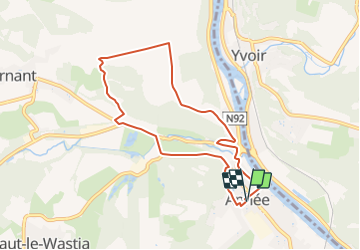
Percorso A piedi di 7,2 km da scoprire a Wallonie, Namur, Anhée. Questo percorso è proposto da Commissariat général au Tourisme.
Trail created by Vallée de la Meuse Namur-Dinant.
Departure : Place communale of Anhée.
Cross the main road Namur-Dinant under the protection of the lights. Note the plate recalling the height of the Meuse during the floods of 1925-25. Take the rue Ribot. At the T, go straight on through the camping. At the towpath, along the Meuse, follow its course on the left. After the confluence of the Molignée, carefully cross the main road to enter the Route de la Molignée and enter Moulins-Warnant.
The buildings of the restaurant on your left are those of an old forge from the beginning of the 17th century; those on the right are an old blast furnace transformed into a flour mill and now into CAFT. Follow this road between two reaches that have remained almost unchanged for nearly 400 years. After 200m, turn right into the rue d'Henneumont. This macadamized street winds up. Further up, overlook the Rue de la Bossière on the right. Enter the wood where violent fighting took place during the German invasion on May 13, 1940. On your left, a humble cross reminds us of the accident that cost the life of a farmer. Cross the farm of Henneumont. Very old and probably built by the former abbey of Moulins, it was burned by the Germans in 1914. Ignore the first path on the left and continue straight ahead in the middle of the fields. Notice the panorama on the right bank of the Meuse and the runes of Poilvache to the South-South-East. After about 500m, turn left towards a high tension line. After passing under it, continue to the macadamized road and a shed. Follow this road for 50m, to the left (it leads to the farm of Corbais). Neglect the path that goes directly along the wood, but take the one that, shortly after, goes into the wood on your left. Along this path, you can still see the trenches of the French army of 1940. At the bottom, at the exit of the wood, turn left, pass in front of the ND de Lourdes chapel of 1873 and follow the path under the woods. Around the old quarry, there is a beautiful view of Moulins: the pretty farm, the castle (former abbey), and the old copper factory. At the end of the wood, the path goes along the back of a small camping site, becomes paved and meets the rue d'Henneumont which you take to the right. Directly after, turn left on rue de la Molignée to come back to Anhée. Turn right into rue Grande. Note the window of Mr. Castreman with the old motorcycles. Go back to the church and the starting point.


Marcia

Marcia

Marcia

Marcia

Marcia

Marcia

Marcia

Marcia

Marcia