Percorso A piedi Doische - Falizes - Photo

Randonnées du CGT GUIDE+

© OpenStreetMap contributors
Lunghezza
Lunghezza
1,7 km
Altitudine massima
Altitudine massima
222 m
Dislivello positivo
Dislivello positivo
32 m
Km-Effort
Km-Effort  
2,1 km
Altitudine minima
Altitudine minima
189 m
Dislivello negativo
Dislivello negativo
27 m
Boucle
Boucle
Sì
Data di creazione :
2022-02-08 11:31:24.838
Ultima modifica :
2022-02-21 10:12:44.752

(0 Recensione)

A piedi
A piedi
28m
Difficoltà : Facile

Scannerizza questo codice QR per aprire il percorso nell'applicazione SityTrail

Applicazione GPS da escursionismo GRATUITA

Logo SityTrail SityTrail

IGN / Istituti geografici

Scarica SityTrail dall'App Store Scarica SityTrail da Google Play

Logo SityTrail SityTrail World

Il mondo è tuo

Scarica SityTrail dall'App Store Scarica SityTrail da Google Play Scarica SityTrail da Huawei AppGallery

Chi siamo

Percorso A piedi di 1,7 km da scoprire a Wallonie, Namur, Doische. Questo percorso è proposto da Commissariat général au Tourisme.

Descrizione

Trail created by Pays des Lacs.


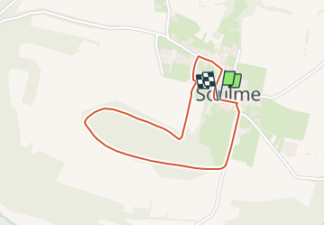
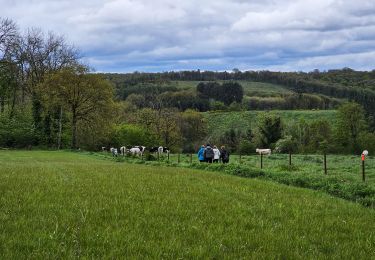
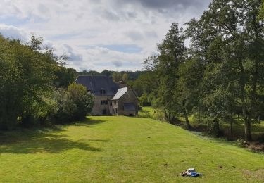
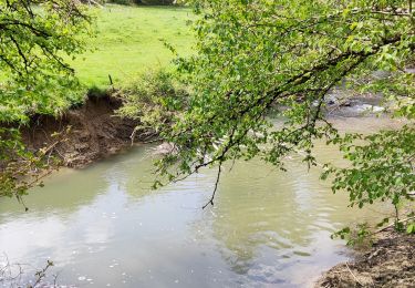
This short walk, which departs from Sainte-Colombe church in Soulme, crosses a wooded area to the south of the village. A sign dating from the German occupation during World War II still hangs on the gable of a former farmhouse, which forms the corner of Rue Désiré Mathieu and the path that leads to Hamoir Mill. The walk passes close to the former Falize quarrying site, which was used to construct the village itself. There were also pastures for goats and sheep on the limestone lawns. The village, which is listed as one of the Most Beautiful Villages of Wallonia, has retained its traditional architecture, the source of its charm. The Romanesque Sainte-Colombe church was built from limestone rubble during the 11th century and is surrounded by the cemetery walls. These are bordered by a stunning row of large chestnut trees.


Profilo altimetrico

Foto

Localizzazione

Paese:
Belgium
Regione :
Wallonie
Dipartimento/Provincia :
Namur
Comune :
Doische
Località :
Unknown
Partenza:(UTM)
623954 ; 5560881 (31U) N.

Percorsi nelle vicinanze

Percorso Marcia Doische - RB-Na-11 La vallée de l’Hermeton - Photo
Marcia
PRO

Marcia

Medio
(4)
Doische, Wallonie, Namur, Belgium
25 km | 31 km-effort
6h 40min
Sì
Percorso Marcia Doische - RB-Na-11 Raccourci - La vallée de l’Hermeton - Photo
Marcia
PRO

Marcia

Medio
(5)
Doische, Wallonie, Namur, Belgium
19,7 km | 25 km-effort
5h 22min
Sì
Percorso Marcia Doische - De Gochenee vers Soulme par la vallee de l'Ermeton - Photo
Marcia
GUIDE
Desrumaux

Marcia

Medio
(1)
Doische, Wallonie, Namur, Belgium
18,5 km | 24 km-effort
4h 40min
Sì
Percorso Marcia Doische - Promenade à Vodelée - Photo
Marcia
GUIDE
Desrumaux

Marcia

Facile
(1)
Doische, Wallonie, Namur, Belgium
9,3 km | 11,4 km-effort
2h 15min
Sì
Percorso Marcia Florennes - De Morville à Miavoye par le bois et le château de Fontaine - Photo
Marcia
GUIDE
Desrumaux

Marcia

Molto facile
(4)
Florennes, Wallonie, Namur, Belgium
7,5 km | 9,2 km-effort
2h 0min
Sì
Percorso Marcia Onhaye - De Miavoye à Maurenne par le vallon de Féron - Photo
Marcia
GUIDE
Desrumaux

Marcia

Difficile
Onhaye, Wallonie, Namur, Belgium
11,2 km | 14,3 km-effort
3h 15min
Sì
Percorso Marcia Philippeville - Balade à Omezée - Photo
Marcia
GUIDE
Desrumaux

Marcia

Difficile
Philippeville, Wallonie, Namur, Belgium
11,4 km | 14,2 km-effort
3h 13min
Sì
Percorso Marcia Doische - La Boucle de l'Hermeton - Photo
Marcia
GUIDE
Desrumaux

Marcia

Difficile
Doische, Wallonie, Namur, Belgium
19 km | 24 km-effort
2h 50min
Sì
Percorso Marcia Doische - Promenade de la Bonne-Fontaine   - Photo
Marcia
GUIDE+

Marcia

Medio
(3)
Doische, Wallonie, Namur, Belgium
7,3 km | 9,4 km-effort
2h 7min
Sì


Chiudi
I miei abbonamenti