![](/images/other/stat-length.png)
![Percorso A piedi Anhée - Les Abbayes - Photo](https://media.geolcdn.com/t/1900/400/ext.pjpeg?maxdim=2&url=https%3A%2F%2Fpivotmedia.tourismewallonie.be%2FOTH-A0-0066-29R6%2FOTH-A0-0066-29R6.jpg)
Les Abbayes
Commissariat général au Tourisme
Randonnées du CGT GUIDE+
![Lunghezza](/images/other/stat-length.png)
![Altitudine massima](https://static1.geolcdn.com/siteimages/upload/files/1508320355ic_sort_altitude_max_24dp.png)
![Dislivello positivo](https://static1.geolcdn.com/siteimages/upload/files/1508320355ic_sort_den_pos_24dp.png)
![Km-Effort](/images/other/stat-length.png)
![Altitudine minima](https://static1.geolcdn.com/siteimages/upload/files/1508320355ic_sort_altitude_min_24dp.png)
![Dislivello negativo](https://static1.geolcdn.com/siteimages/upload/files/1508320355ic_sort_den_neg_24dp.png)
![Boucle](https://static1.geolcdn.com/siteimages/upload/files/16400158638029165_repeat_loop_refresh_sync_direction_icon.png)
![A piedi](https://static1.geolcdn.com/sitytour/trail-icons/100.png)
58m
Difficoltà : Facile
![Scannerizza questo codice QR per aprire il percorso nell'applicazione SityTrail](https://capi.geolives.com/qq0zvz2zws4bq2lad0pu/sitytour/trails/3080965/qr.png?size=200)
Applicazione GPS da escursionismo GRATUITA
Chi siamo
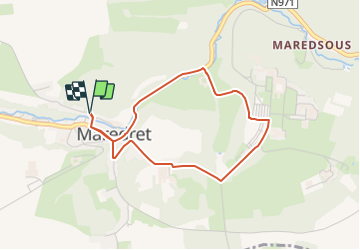
Percorso A piedi di 3,3 km da scoprire a Wallonie, Namur, Anhée. Questo percorso è proposto da Commissariat général au Tourisme.
Descrizione
Trail created by Vallée de la Meuse Namur-Dinant.
Walk of a little less than 6 kilometers to discover the Abbeys of Maredret and Maredsous.
You start along the Ravel, turn right and walk along the river Molignée. Just before the Castle of Maredsous, turn left and go up the asphalt road to the Abbey of Maredsous.
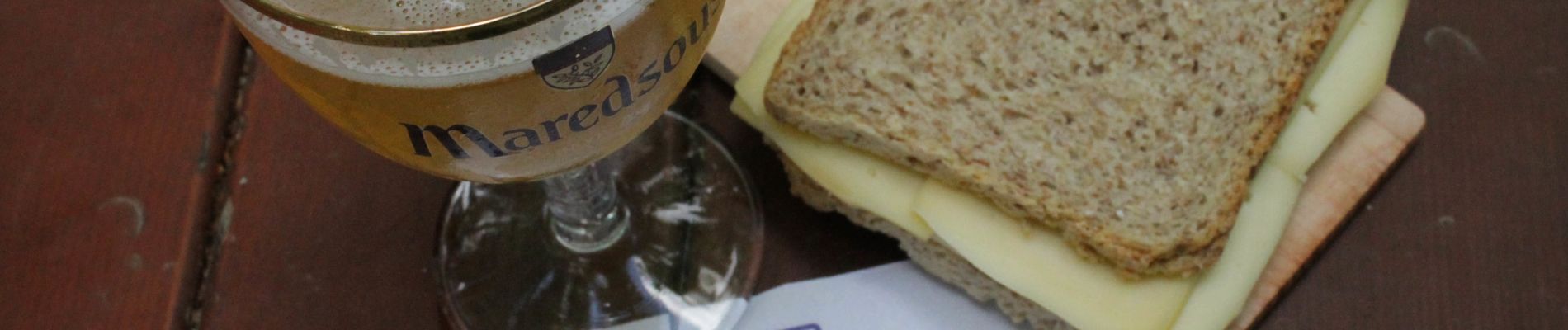
Here you can have a break and taste the traditional beer and cheese sandwiches.
Then, when you arrive at the Abbey, you drive along the parking lot and turn right after about one kilometer. You arrive at the Abbey of Maredret and walk down the street to the starting point.
Localizzazione
Commenti
Percorsi nelle vicinanze
![Marcia Marcia](https://static1.geolcdn.com/sitytour/trail-icons/101.png)
Marcia
![](/images/other/stat-length.png)
![](https://static1.geolcdn.com/siteimages/upload/files/16400158638029165_repeat_loop_refresh_sync_direction_icon.png)
![Percorso Marcia Anhée - RB-Na-22-raccourci_Vignobles-et-Jardins-d’eau - Photo](https://media.geolcdn.com/t/375/260/9e39c4d6-ac1b-4acf-9686-7baae428f1a0.jpg&format=jpg&maxdim=2)
![Marcia Marcia](https://static1.geolcdn.com/sitytour/trail-icons/101.png)
Marcia
![](/images/other/stat-length.png)
![](https://static1.geolcdn.com/siteimages/upload/files/16400158638029165_repeat_loop_refresh_sync_direction_icon.png)
![Percorso Marcia Anhée - RB-Na-22_Vignobles-et-Jardins-d’eau - Photo](https://media.geolcdn.com/t/375/260/8622883f-03f3-4eff-8458-0cb9f1aba19e.jpg&format=jpg&maxdim=2)
![Marcia Marcia](https://static1.geolcdn.com/sitytour/trail-icons/101.png)
Marcia
![](/images/other/stat-length.png)
![](https://static1.geolcdn.com/siteimages/upload/files/16400158638029165_repeat_loop_refresh_sync_direction_icon.png)
![Percorso Marcia Anhée - RB-Na-16 - Paysages de la Molignée - Photo](https://media.geolcdn.com/t/375/260/ext.jpg?maxdim=2&url=https%3A%2F%2Fservices.sitytrail.com%2FGeolivesWS%2FDownloadMedia.ashx%3FTrailID%3D252846%26Media%3D757ed732-5926-4a49-9c27-a2a6c3abf11c.jpg)
![Marcia Marcia](https://static1.geolcdn.com/sitytour/trail-icons/101.png)
Marcia
![](/images/other/stat-length.png)
![](https://static1.geolcdn.com/siteimages/upload/files/16400158638029165_repeat_loop_refresh_sync_direction_icon.png)
![Marcia Marcia](https://static1.geolcdn.com/sitytour/trail-icons/101.png)
Marcia
![](/images/other/stat-length.png)
![](https://static1.geolcdn.com/siteimages/upload/files/16400158638029165_repeat_loop_refresh_sync_direction_icon.png)
![Percorso Marcia Anhée - RB-Na-16 Raccourci - Paysages de la Molignée - Photo](https://media.geolcdn.com/t/375/260/ext.jpg?maxdim=2&url=https%3A%2F%2Fstatic1.geolcdn.com%2Fsiteimages%2Fupload%2Ffiles%2F1553511878bg_sport_marche.png)
![Marcia Marcia](https://static1.geolcdn.com/sitytour/trail-icons/101.png)
Marcia
![](/images/other/stat-length.png)
![](https://static1.geolcdn.com/siteimages/upload/files/16400158638029165_repeat_loop_refresh_sync_direction_icon.png)
![Percorso Marcia Anhée - Balade de l'abbaye de Maredsous à Ermeton-sur-Biert - Photo](https://media.geolcdn.com/t/375/260/ext.jpg?maxdim=2&url=https%3A%2F%2Fservices.sitytrail.com%2FGeolivesWS%2FDownloadMedia.ashx%3FTrailID%3D1068875%26Media%3D20181106140411.jpg)
![Marcia Marcia](https://static1.geolcdn.com/sitytour/trail-icons/101.png)
Marcia
![](/images/other/stat-length.png)
![](https://static1.geolcdn.com/siteimages/upload/files/16400158638029165_repeat_loop_refresh_sync_direction_icon.png)
![Marcia Marcia](https://static1.geolcdn.com/sitytour/trail-icons/101.png)
Marcia
![](/images/other/stat-length.png)
![](https://static1.geolcdn.com/siteimages/upload/files/16400158638029165_repeat_loop_refresh_sync_direction_icon.png)
![Percorso Marcia Anhée - Balade à Denée - Photo](https://media.geolcdn.com/t/375/260/ext.jpg?maxdim=2&url=https%3A%2F%2Fservices.sitytrail.com%2FGeolivesWS%2FDownloadMedia.ashx%3FTrailID%3D274406%26Media%3Dfced633a-60e9-42df-93a1-c2f30963bb68.JPG)
![Marcia Marcia](https://static1.geolcdn.com/sitytour/trail-icons/101.png)
Marcia
![](/images/other/stat-length.png)
![](https://static1.geolcdn.com/siteimages/upload/files/16400158638029165_repeat_loop_refresh_sync_direction_icon.png)