Percorso A piedi Anhée - Panorama de la Cour - Photo

Panorama de la Cour

Randonnées du CGT GUIDE+

© OpenStreetMap contributors
Lunghezza
Lunghezza
4,5 km
Altitudine massima
Altitudine massima
283 m
Dislivello positivo
Dislivello positivo
115 m
Km-Effort
Km-Effort  
6,1 km
Altitudine minima
Altitudine minima
180 m
Dislivello negativo
Dislivello negativo
115 m
Boucle
Boucle
Sì
Data di creazione :
2022-02-08 11:31:17.769
Ultima modifica :
2022-02-21 10:12:38.98

(0 Recensione)

A piedi
A piedi
1h22
Difficoltà : Facile

Scannerizza questo codice QR per aprire il percorso nell'applicazione SityTrail

Applicazione GPS da escursionismo GRATUITA

Logo SityTrail SityTrail

IGN / Istituti geografici

Scarica SityTrail dall'App Store Scarica SityTrail da Google Play

Logo SityTrail SityTrail World

Il mondo è tuo

Scarica SityTrail dall'App Store Scarica SityTrail da Google Play Scarica SityTrail da Huawei AppGallery

Chi siamo

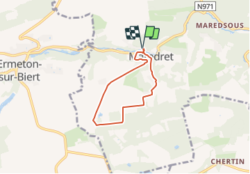
Percorso A piedi di 4,5 km da scoprire a Wallonie, Namur, Anhée. Questo percorso è proposto da Commissariat général au Tourisme.

Descrizione

Trail created by Vallée de la Meuse Namur-Dinant.


Departure : Maredret Art Gallery.

At the end of the gallery, take the rue des Artisans to the right. Directly at the crossroads, take the small street that goes up in front of you, rue Roland. At the top of this street, take a path on the back left that winds up to the Cour farm. At the next crossroads, continue straight ahead. After 1Km and a pond on the left, take the path on the left which enters the wood. Join a road that you take to the left. After 300m, take a track on the right. Join the street Haie de la Motte that you take to the left on 50m, then directly to the right towards the chapel ND de Grâce. Go back down the rue Neuve Niole towards the rue des Artisans and the starting point.


Profilo altimetrico

Foto

Localizzazione

Paese:
Belgium
Regione :
Wallonie
Dipartimento/Provincia :
Namur
Comune :
Anhée
Località :
Unknown
Partenza:(Dec)
Partenza:(UTM)
624656 ; 5573553 (31U) N.

Percorsi nelle vicinanze

Percorso Marcia Mettet - RB-Na-23-Sur le plateau de l’Entre-Sambre-et-Meuse - Photo
Marcia
PRO

Marcia

Molto difficile
(8)
Mettet, Wallonie, Namur, Belgium
24 km | 29 km-effort
6h 39min
Sì
Percorso Marcia Anhée - RB-Na-22-raccourci_Vignobles-et-Jardins-d’eau - Photo
Marcia
PRO

Marcia

Molto difficile
(6)
Anhée, Wallonie, Namur, Belgium
16,7 km | 21 km-effort
4h 52min
Sì
Percorso Marcia Anhée - RB-Na-22_Vignobles-et-Jardins-d’eau - Photo
Marcia
PRO

Marcia

Molto difficile
(11)
Anhée, Wallonie, Namur, Belgium
19,5 km | 25 km-effort
5h 46min
Sì
Percorso Marcia Anhée - RB-Na-16 - Paysages de la Molignée - Photo
Marcia
PRO

Marcia

Medio
(19)
Anhée, Wallonie, Namur, Belgium
18,3 km | 24 km-effort
5h 13min
Sì
Percorso Marcia Mettet - RB-Na-23-racc-Sur le plateau de l’Entre-Sambre-et-Meuse - Photo
Marcia
PRO

Marcia

Difficile
(8)
Mettet, Wallonie, Namur, Belgium
14 km | 16,7 km-effort
3h 47min
Sì
Percorso Marcia Anhée - RB-Na-16 Raccourci - Paysages de la Molignée - Photo
Marcia
PRO

Marcia

Facile
(15)
Anhée, Wallonie, Namur, Belgium
13 km | 16,6 km-effort
3h 40min
Sì
Percorso Marcia Anhée - Balade de l'abbaye de Maredsous à Ermeton-sur-Biert - Photo
Marcia
GUIDE
Desrumaux

Marcia

Facile
(4)
Anhée, Wallonie, Namur, Belgium
9,2 km | 11,9 km-effort
2h 32min
Sì
Percorso Marcia Anhée - Sosoye - Circuit Natura 2000, des sites qui valent le détour - Na11 - Photo
Marcia
GUIDE+

Marcia

Medio
(5)
Anhée, Wallonie, Namur, Belgium
4,9 km | 6,3 km-effort
1h 21min
Sì
Percorso Marcia Anhée - Balade à Denée - Photo
Marcia
GUIDE
Desrumaux

Marcia

Molto facile
(1)
Anhée, Wallonie, Namur, Belgium
5,8 km | 7,4 km-effort
1h 35min
Sì


Chiudi
I miei abbonamenti