


16,7 km | 21 km-effort


Randonnées du CGT GUIDE+


Applicazione GPS da escursionismo GRATUITA
 SityTrail
IGN / Istituti geografici
SityTrail World
Il mondo è tuo
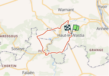
Percorso A piedi di 9,6 km da scoprire a Wallonie, Namur, Anhée. Questo percorso è proposto da Commissariat général au Tourisme.
Trail created by Vallée de la Meuse Namur-Dinant.
Departure : Place d'Haut-le-Wastia.
In front of the church, turn right to go along the school. Turn left in the direction of Anhée with the street Coron des Trys. At the T-junction, turn right onto rue de Sommière for about 50 meters, then turn left onto the path called Creute. It winds its way down into the woods and, after first skirting the fence of a large property, follows the surrounding wall, then crosses the Molignée on an old bridge. Turn left onto the macadamized road between Anhée and Maredsous. Cross the disused SNCB line that used to link Dinant to Tamines or Florennes and pass the Villa des Lapins. At the Y-junction, take the macadamized road going up to Salet. After 200m, pass the Trou des Nutons, and after 200m take the path that goes up to the right in the wood. This path, after a field, brings you to the hamlet of Salet near the N.-D. De Lourdes church. Turn right into the rue de Foy and walk along the big old farm. At the Y intersection, near a statue of the Sacred Heart, ignore the road on the right leading to the church. Continue straight ahead on the macadamized road towards the fields. Ignore the first road on the left but take the next one, after 800m, and go towards Foy. Follow the road as it bends to the right along the farm, and then immediately turn left along the path that follows an ancient Roman road. The path becomes a gravel path and starts a descent in the undergrowth towards the road of La Molignée. Cross the main road and cross the bridge over the Stave (which a little further downstream joins the Floyon at the foot of Montaigne to form the Molignée) and thus enter the hamlet which owes its name to the iron industrial activity which developed there for centuries, i.e. Marteau.
Follow the macadamized road in its left-hand bend towards the ruins of the Montaigne castle, at the level of which it becomes gravel and descends towards the Floyon on the right. Cross this stream and continue straight ahead through the Saute wood by the torrential valley. After 1 km, almost at the exit of the wood, turn left on the dirt road that comes out of the wood, in front of an isolated house, and go towards Haut-le-Wastia. At the Monument Français, go down to the village following the road to Sommière. Ignore the street of Mossiat on the right and at the level of the chapel St Roch, take on the right to borrow the street of the Center which, after having skirted the cemetery, goes up in sinuous towards the church of the departure. From there, you can make a 300m round trip to the Berdinsart viewpoint by a path on the other side of the square. Then you take the road to the right for 100m.

Marcia

Marcia

Marcia

Marcia

Marcia

Marcia

Marcia

Marcia

Marcia