


16,7 km | 21 km-effort


Randonnées du CGT GUIDE+


Applicazione GPS da escursionismo GRATUITA
 SityTrail
IGN / Istituti geografici
SityTrail World
Il mondo è tuo
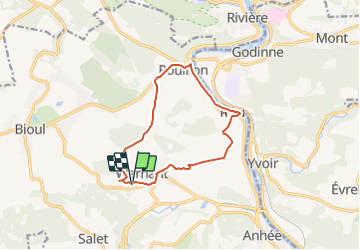
Percorso A piedi di 10,7 km da scoprire a Wallonie, Namur, Anhée. Questo percorso è proposto da Commissariat général au Tourisme.
Trail created by Vallée de la Meuse Namur-Dinant.
Departure : Place de l'église d'Annevoie.
On the square, position yourself so that you have a waterwheel on your right and the church of St-Antoine on your left. Go straight ahead on the macadamized road which curves to the right before starting a slight climb. After 400m, at the Y junction, at the chapel dedicated to the Virgin and called Chapelle du Berger, continue to the right. This gravel path enters the fields and passes under a power line. At the next Y-junction, continue on the path that goes slightly right and enters the woods. About 1Km further in the woods, at the crossroads of the Saint-Hubert chapel, take the left track. After 100m, go straight down, and 20m later, at the Villa Thiran, take the path on the right which will go along a wood, for 400m, behind the houses of Warnant, and will bring you to the Ruelle Colleau which you will go down by bending to the left. At the bottom, after 300m, at the T-junction, turn right. At the Union Warnantaise hall, turn left (it would be a pity not to have made a short 200m round trip to the Ste-Adèle fountain and the N.-D de Beauraing chapel). After the small bridge, ignore the first road on the right (rue du Prince), and take the second one (rue de Quincay, named after the Poitevin village twinned with Warnant) near the church. At the crossroads of the big farm, turn left. Follow the road for 600m and turn left at the crossroads of the chapel N.-D de Hal. At the next T-junction, take a path that climbs up the hill and passes the side of a house. This path becomes grassy. It widens as it joins another one near an isolated house. Go behind this house, then along the Corbais farm. At a long left turn, ignore the paths on the right that go into the woods and take the path on the right next to a shed that goes between fields and under a power line. At the T-junction in the countryside, turn left towards a small wood. Cross this wood and go down to a farm. Drive around the farm on the left and then turn right to enter Rue des Campagnes à Hun. Near the Saint-Christophe church, turn right on the National road towards Dinant. After 100m, cross the road on the passage and take the street of En-Bas to join the towpath. There, turn left to follow the Meuse towards Namur. At the approach of the Godinne bridge, at the ball park of Rouillon, turn left to join and cross the main road. Turn right into the Chemin des Forges. At the end of this macadamized street on the right, take the series of stairs, turn left to go back to the starting point by the main road then by the street of the church on the left. You will pass the Gardens of Annevoie and the castle.


Marcia

Marcia

Marcia

Marcia

Marcia

Marcia

Marcia

Marcia

Marcia