Percorso A piedi Anhée - Ronquêre - Photo

Randonnées du CGT GUIDE+

© OpenStreetMap contributors
Lunghezza
Lunghezza
6,9 km
Altitudine massima
Altitudine massima
266 m
Dislivello positivo
Dislivello positivo
112 m
Km-Effort
Km-Effort  
8,4 km
Altitudine minima
Altitudine minima
209 m
Dislivello negativo
Dislivello negativo
112 m
Boucle
Boucle
Sì
Data di creazione :
2022-02-08 11:23:02.762
Ultima modifica :
2022-02-21 10:04:15.003

(0 Recensione)

A piedi
A piedi
1h54
Difficoltà : Facile

Scannerizza questo codice QR per aprire il percorso nell'applicazione SityTrail

Applicazione GPS da escursionismo GRATUITA

Logo SityTrail SityTrail

IGN / Istituti geografici

Scarica SityTrail dall'App Store Scarica SityTrail da Google Play

Logo SityTrail SityTrail World

Il mondo è tuo

Scarica SityTrail dall'App Store Scarica SityTrail da Google Play Scarica SityTrail da Huawei AppGallery

Chi siamo

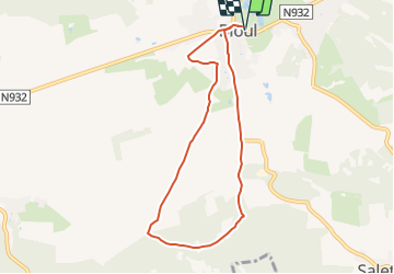
Percorso A piedi di 6,9 km da scoprire a Wallonie, Namur, Anhée. Questo percorso è proposto da Commissariat général au Tourisme.

Descrizione

Trail created by Vallée de la Meuse Namur-Dinant.


Departure : Place Vaxelaire in Bioul


At the beginning of the square, turn right on the road of Fraire.

After 150m, turn left into the rue de Salet. This street goes down, passes near a St-Roch chapel at a crossroads, then goes up.

Continue straight on the main road to leave Bioul.

After leaving the village, at the crossroads following the fields, continue straight down towards the Ronquêre wood.

After 300m, at the crow's feet, take the main road on the right.

Then after 200m, take the left track. After 500m, in the middle of the wood, take the old road on the right which linked Salet and Denée.

At the end of the wood, after 1200m, at the place called Chapeau de Curé, take the right road along the wood that you follow to come back to Bioul through fields.

At the next crossroads, continue straight ahead.

At the farm, go straight on, then 100m further on, turn left, then left again after 200m, so as to bypass the complex of Chérimont.

Then turn left to reach the war memorial and the main road that will bring you to your starting point.


Profilo altimetrico

Localizzazione

Paese:
Belgium
Regione :
Wallonie
Dipartimento/Provincia :
Namur
Comune :
Anhée
Località :
Unknown
Partenza:(Dec)
Partenza:(UTM)
628016 ; 5577270 (31U) N.

Percorsi nelle vicinanze

Percorso Marcia Anhée - RB-Na-22-raccourci_Vignobles-et-Jardins-d’eau - Photo
Marcia
PRO

Marcia

Molto difficile
(6)
Anhée, Wallonie, Namur, Belgium
16,7 km | 21 km-effort
4h 52min
Sì
Percorso Marcia Anhée - RB-Na-22_Vignobles-et-Jardins-d’eau - Photo
Marcia
PRO

Marcia

Molto difficile
(11)
Anhée, Wallonie, Namur, Belgium
19,5 km | 25 km-effort
5h 46min
Sì
Percorso Marcia Anhée - RB-Na-16 - Paysages de la Molignée - Photo
Marcia
PRO

Marcia

Medio
(19)
Anhée, Wallonie, Namur, Belgium
18,3 km | 24 km-effort
5h 13min
Sì
Percorso Marcia Anhée - RF-Na-05 Annevoie, côté Jardins_Grande-boucle - Photo
Marcia
PRO

Marcia

Medio
(11)
Anhée, Wallonie, Namur, Belgium
11,3 km | 14,5 km-effort
3h 6min
Sì
Percorso Marcia Anhée - RF-Na-05 Annevoie, côté Jardins_Petite-boucle - Photo
Marcia
PRO

Marcia

Facile
(7)
Anhée, Wallonie, Namur, Belgium
7,4 km | 10 km-effort
2h 7min
Sì
Percorso Marcia Anhée - RB-Na-16 Raccourci - Paysages de la Molignée - Photo
Marcia
PRO

Marcia

Facile
(16)
Anhée, Wallonie, Namur, Belgium
13 km | 16,6 km-effort
3h 40min
Sì
Percorso Marcia Anhée - Balade de l'abbaye de Maredsous à Ermeton-sur-Biert - Photo
Marcia
GUIDE
Desrumaux

Marcia

Facile
(4)
Anhée, Wallonie, Namur, Belgium
9,2 km | 11,9 km-effort
2h 32min
Sì
Percorso Marcia Anhée - Sosoye - Circuit Natura 2000, des sites qui valent le détour - Na11 - Photo
Marcia
GUIDE+

Marcia

Medio
(5)
Anhée, Wallonie, Namur, Belgium
4,9 km | 6,3 km-effort
1h 21min
Sì
Percorso Marcia Yvoir - De Godinne à Rivière par le point de vue des 7 Meuses - Photo
Marcia
GUIDE
Desrumaux

Marcia

Facile
(5)
Yvoir, Wallonie, Namur, Belgium
8,5 km | 11,6 km-effort
2h 30min
Sì


Chiudi
I miei abbonamenti