Percorso Mountainbike Thuin - De la Ville au Village - Photo

De la Ville au Village

Randonnées du CGT GUIDE+

© OpenStreetMap contributors
Lunghezza
Lunghezza
19 km
Altitudine massima
Altitudine massima
192 m
Dislivello positivo
Dislivello positivo
248 m
Km-Effort
Km-Effort  
22 km
Altitudine minima
Altitudine minima
118 m
Dislivello negativo
Dislivello negativo
245 m
Boucle
Boucle
Sì
Data di creazione :
2022-02-08 11:22:08.999
Ultima modifica :
2022-02-21 10:03:15.489

(0 Recensione)

Mountainbike
Mountainbike
1h32
Difficoltà : Medio

Scannerizza questo codice QR per aprire il percorso nell'applicazione SityTrail

Applicazione GPS da escursionismo GRATUITA

Logo SityTrail SityTrail

IGN / Istituti geografici

Scarica SityTrail dall'App Store Scarica SityTrail da Google Play

Logo SityTrail SityTrail World

Il mondo è tuo

Scarica SityTrail dall'App Store Scarica SityTrail da Google Play Scarica SityTrail da Huawei AppGallery

Chi siamo

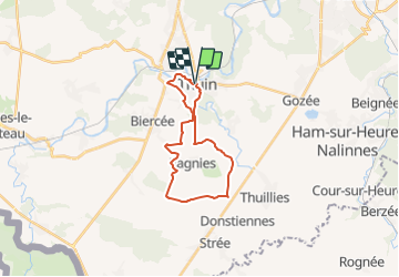
Percorso Mountainbike di 19 km da scoprire a Wallonie, Hainaut, Thuin. Questo percorso è proposto da Commissariat général au Tourisme.

Descrizione

Trail created by Pays des Lacs.


This is quite a challenging route on which you will discover the tourist woods and their chapels and countryside, go through Ragnies, the ‘Most Beautiful Village in Wallonia’, and explore the mediaeval city of Thuin. The Thuin belfry and its hanging gardens, the Biercée distillery, Chêne farm, etc. It goes without saying that there are many impressive sites along this walk. At the Maladrerie, a ‘potale’ and a chapel tell of the cult of Saint-Roch, who was prayed for to ward against the plague. In the centre of Thuin, the top of the climb through the hanging gardens offers a superb view over the Sambre and Biesmelle valleys. The paved streets raise the difficulty of the route. You then walk through the Grand Bon Dieu woods with its art and sports installations.


Profilo altimetrico

Foto

Localizzazione

Paese:
Belgium
Regione :
Wallonie
Dipartimento/Provincia :
Hainaut
Comune :
Thuin
Località :
Unknown
Partenza:(Dec)
Partenza:(UTM)
591552 ; 5577176 (31U) N.

Percorsi nelle vicinanze

Percorso Marcia Fontaine-l'Évêque - de l'Abbaye d'Aulne au hameau de Hourpes - Thuin - Photo
Marcia
GUIDE
Desrumaux

Marcia

Molto facile
(2)
Fontaine-l'Évêque, Wallonie, Hainaut, Belgium
8,7 km | 10,9 km-effort
3h 16min
Sì
Percorso Marcia Thuin - La balade du Bois des Waibes. - Photo
Marcia
GUIDE
Desrumaux

Marcia

Facile
(4)
Thuin, Wallonie, Hainaut, Belgium
9,9 km | 12 km-effort
2h 41min
Sì
Percorso Marcia Montigny-le-Tilleul - Balade en Val de Sambre - De Landelies à l'Abbaye d'Aulne  - Photo
Marcia
GUIDE
Desrumaux

Marcia

Molto facile
(1)
Montigny-le-Tilleul, Wallonie, Hainaut, Belgium
6,6 km | 8 km-effort
1h 49min
Sì
Percorso Marcia Lobbes - Balade à Mont-Sainte-Geneviève - Photo
Marcia
GUIDE
Desrumaux

Marcia

Molto facile
(3)
Lobbes, Wallonie, Hainaut, Belgium
9,1 km | 10,4 km-effort
2h 18min
Sì
Percorso Marcia Thuin - RB-Ha-08 – Raccourci 1 - Tours et détours entre Beaumont et Barbençon - Photo
Marcia
PRO

Marcia

Molto difficile
(2)
Thuin, Wallonie, Hainaut, Belgium
25 km | 32 km-effort
7h 12min
Sì
Percorso Marcia Thuin - RB-Ha-08 - Tours et détours entre Beaumont et Barbençon - Photo
Marcia
PRO

Marcia

Molto difficile
(2)
Thuin, Wallonie, Hainaut, Belgium
22 km | 28 km-effort
6h 26min
Sì
Percorso Marcia Thuin - Thuin - De la Ville Haute à la Ville Basse - Photo
Marcia
GUIDE
Desrumaux

Marcia

Facile
(4)
Thuin, Wallonie, Hainaut, Belgium
4,5 km | 6,6 km-effort
1h 20min
Sì
Percorso Marcia Thuin - Ragnies  - Photo
Marcia
ELISECRO

Marcia

Molto facile
(3)
Thuin, Wallonie, Hainaut, Belgium
6,6 km | 7,3 km-effort
1h 14min
Sì
Percorso Marcia Thuin - BIESME S THUIN - Photo
Marcia
schuyteneer

Marcia

Molto facile
(1)
Thuin, Wallonie, Hainaut, Belgium
5,4 km | 6,6 km-effort
1h 34min
Sì


Chiudi
I miei abbonamenti