Percorso A piedi Andenne - Grande France - Photo

Grande France

Randonnées du CGT GUIDE+

© OpenStreetMap contributors
Lunghezza
Lunghezza
8,6 km
Altitudine massima
Altitudine massima
226 m
Dislivello positivo
Dislivello positivo
219 m
Km-Effort
Km-Effort  
11,5 km
Altitudine minima
Altitudine minima
74 m
Dislivello negativo
Dislivello negativo
218 m
Boucle
Boucle
Sì
Data di creazione :
2022-02-08 11:21:37.218
Ultima modifica :
2022-02-21 10:02:37.906

(0 Recensione)

A piedi
A piedi
2h36
Difficoltà : Facile

Scannerizza questo codice QR per aprire il percorso nell'applicazione SityTrail

Applicazione GPS da escursionismo GRATUITA

Logo SityTrail SityTrail

IGN / Istituti geografici

Scarica SityTrail dall'App Store Scarica SityTrail da Google Play

Logo SityTrail SityTrail World

Il mondo è tuo

Scarica SityTrail dall'App Store Scarica SityTrail da Google Play Scarica SityTrail da Huawei AppGallery

Chi siamo

Percorso A piedi di 8,6 km da scoprire a Wallonie, Namur, Andenne. Questo percorso è proposto da Commissariat général au Tourisme.

Descrizione

Trail created by Vallée de la Meuse Namur-Dinant.


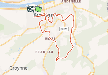
This 9km hike starts at the Andenne Arena and takes you through the countryside and woods east of Andenne.


You start your walk in the small streets of the city center of Andenne before reaching the Ancienne Chaussée de Ciney and the hamlet of Reppe. You carefully cross the Chaussée de Ciney and reach the Bois d'Heer and its paths. You go up through the woods and then down into a charming valley to the picturesque Moulin de Kevret. The walk then takes you along the beautiful paths of the places called Hautebise, Chawagne and Grande France. You will then arrive at the magnificent viewpoint of the Calvary, an old procession path that will take you back to the city center to discover the Place du Chapitre, the historical heart of Andenne. The end of the walk leads you to the new Promenade des Ours where you will find our offices. You end your tour with a passage on the Place des Tilleuls where you can quench your thirst and eat before reaching the Andenne Arena.


Profilo altimetrico

Foto

Localizzazione

Paese:
Belgium
Regione :
Wallonie
Dipartimento/Provincia :
Namur
Comune :
Andenne
Località :
Unknown
Partenza:(UTM)
648330 ; 5595085 (31U) N.

Percorsi nelle vicinanze

Percorso Marcia Andenne - RB-Na-17 - Andenne - 2025-01-20 - Photo
Marcia
PRO

Marcia

Molto difficile
(14)
Andenne, Wallonie, Namur, Belgium
17,8 km | 23 km-effort
5h 18min
Sì
Percorso Marcia Andenne - Balade dans la Réserve Naturelle de Sclaigneaux - Andenne - Photo
Marcia
GUIDE
Desrumaux

Marcia

Facile
(5)
Andenne, Wallonie, Namur, Belgium
8,2 km | 11,1 km-effort
2h 24min
Sì
Percorso Marcia Andenne - GESVES- Goyet- n°08- Eau - Photo
Marcia
PRO

Marcia

Difficile
(9)
Andenne, Wallonie, Namur, Belgium
9,1 km | 12,3 km-effort
2h 36min
Sì
Percorso Marcia Andenne - La Randonnée des Aguesses - Photo
Marcia
GUIDE+

Marcia

Facile
(2)
Andenne, Wallonie, Namur, Belgium
7,4 km | 9,7 km-effort
2h 8min
Sì
Percorso Mountainbike Andenne - Chaine en Chêne 2012 - 50 km - Photo
Mountainbike
GUIDE+

Mountainbike

Difficile
(1)
Andenne, Wallonie, Namur, Belgium
50 km | 65 km-effort
1h 44min
Sì
Percorso Mountainbike Andenne - Chaine en Chêne 2011 - 40km - Photo
Mountainbike
GUIDE+

Mountainbike

Difficile
(1)
Andenne, Wallonie, Namur, Belgium
37 km | 47 km-effort
3h 0min
Sì
Percorso Mountainbike Andenne - Chaine en Chêne 2012 - 30km - Photo
Mountainbike
GUIDE+

Mountainbike

Difficile
(1)
Andenne, Wallonie, Namur, Belgium
30 km | 38 km-effort
2h 28min
Sì
Percorso Marcia Gesves - GESVES- Haltinne- N°09- Patrimoine - Photo
Marcia
PRO

Marcia

Difficile
(5)
Gesves, Wallonie, Namur, Belgium
12,1 km | 16,2 km-effort
3h 26min
Sì
Percorso Marcia Héron - Promenade des châteaux (Couthuin)  - Photo
Marcia
GUIDE+

Marcia

Medio
(2)
Héron, Wallonie, Liegi, Belgium
9,1 km | 10,7 km-effort
2h 25min
Sì


Chiudi
I miei abbonamenti