Percorso Mountainbike Andenne - Echappée Grand Andenne - Photo

Echappée Grand Andenne

Randonnées du CGT GUIDE+

© OpenStreetMap contributors
Lunghezza
Lunghezza
29 km
Altitudine massima
Altitudine massima
226 m
Dislivello positivo
Dislivello positivo
674 m
Km-Effort
Km-Effort  
38 km
Altitudine minima
Altitudine minima
68 m
Dislivello negativo
Dislivello negativo
675 m
Boucle
Boucle
Sì
Data di creazione :
2022-02-08 11:21:21.769
Ultima modifica :
2022-02-21 10:02:23.667

(1 Recensione)

Mountainbike
Mountainbike
2h36
Difficoltà : Difficile

Scannerizza questo codice QR per aprire il percorso nell'applicazione SityTrail

Applicazione GPS da escursionismo GRATUITA

Logo SityTrail SityTrail

IGN / Istituti geografici

Scarica SityTrail dall'App Store Scarica SityTrail da Google Play

Logo SityTrail SityTrail World

Il mondo è tuo

Scarica SityTrail dall'App Store Scarica SityTrail da Google Play Scarica SityTrail da Huawei AppGallery

Chi siamo

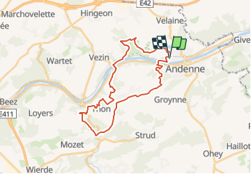
Percorso Mountainbike di 29 km da scoprire a Wallonie, Namur, Andenne. Questo percorso è proposto da Commissariat général au Tourisme.

Descrizione

Trail created by Vallée de la Meuse Namur-Dinant.


This great tour takes you to the discovery of the Grand Andenne.


You start your tour in Seilles where you will discover the Joseph Wauters Square, then the small Jean Tousseul Square where you will see the bust of the famous author.

You then pass by the beautiful Romanesque church of Saint-Etienne before reaching the Sclaigneaux Nature Reserve.

At the end of the wood, you will see the Chant d'Oiseaux educational farm.

You then go down into the Loysse valley to join the Meuse river which you follow until you reach the Sclaigneaux bridge where you cross to go to Sclayn.

You then pass in front of the majestic Saint-Maurice Church, the second Romanesque church of your route.

You go along the Fond des Vaux before reaching the Marchempré quarry. The site is closed and secured but it offers nevertheless very beautiful points of view on the rocks and the basin.

You will then discover Thon-Samson, classified among the Most Beautiful Villages of Wallonia.

Then you go down in the Samson Valley before going up to the village of Maizeret.

A very beautiful section of the GR575 takes you to the Bois d'Herpet before going down in the valley and going up by the Try de Goyet to Bonneville.

In the middle of the fields, you will come across the pretty little chapel Notre-Dame du Bon Secours. Do not hesitate to stop there to admire the view on the countryside !

You go around Bonneville by the small roads to come back to the Bois de Stud, next to Andenne.

After the golf course, you go down the small paths to reach the lock of Andenne-Seilles which will allow you to cross the Meuse and to return to Seilles.

After a passage along the Castle of Seilles, transformed into apartments, you join the Sports Complex of Seilles, your starting point.


Profilo altimetrico

Foto

Localizzazione

Paese:
Belgium
Regione :
Wallonie
Dipartimento/Provincia :
Namur
Comune :
Andenne
Località :
Unknown
Partenza:(Dec)
Partenza:(UTM)
647612 ; 5595799 (31U) N.

Commenti

Accedi per lasciare un commento o una valutazione


Percorsi nelle vicinanze

Percorso Marcia Andenne - RB-Na-17-Au pays de Sainte-Begge - Photo
Marcia
PRO

Marcia

Molto difficile
(13)
Andenne, Wallonie, Namur, Belgium
17,8 km | 23 km-effort
5h 18min
Sì
Percorso Marcia Andenne - Balade dans la Réserve Naturelle de Sclaigneaux - Andenne - Photo
Marcia
GUIDE
Desrumaux

Marcia

Facile
(5)
Andenne, Wallonie, Namur, Belgium
8,2 km | 11,1 km-effort
2h 24min
Sì
Percorso Marcia Andenne - GESVES- Goyet- n°08- Eau - Photo
Marcia
PRO

Marcia

Difficile
(9)
Andenne, Wallonie, Namur, Belgium
9,1 km | 12,3 km-effort
2h 36min
Sì
Percorso Marcia Andenne - Promenade Thon-Samson - Photo
Marcia
GUIDE+

Marcia

Facile
(2)
Andenne, Wallonie, Namur, Belgium
6,5 km | 8,2 km-effort
1h 30min
Sì
Percorso Marcia Andenne - La Randonnée des Aguesses - Photo
Marcia
GUIDE+

Marcia

Facile
(2)
Andenne, Wallonie, Namur, Belgium
7,4 km | 9,7 km-effort
2h 8min
Sì
Percorso Marcia Andenne - Le Parcours du Trou Perdu - Photo
Marcia
GUIDE+

Marcia

Medio
(3)
Andenne, Wallonie, Namur, Belgium
7,3 km | 9 km-effort
2h 5min
Sì
Percorso Mountainbike Andenne - Chaine en Chêne 2012 - 50 km - Photo
Mountainbike
GUIDE+

Mountainbike

Difficile
(1)
Andenne, Wallonie, Namur, Belgium
50 km | 65 km-effort
1h 44min
Sì
Percorso Mountainbike Andenne - Chaine en Chêne 2011 - 40km - Photo
Mountainbike
GUIDE+

Mountainbike

Difficile
(1)
Andenne, Wallonie, Namur, Belgium
37 km | 47 km-effort
3h 0min
Sì
Percorso Mountainbike Andenne - Chaine en Chêne 2012 - 30km - Photo
Mountainbike
GUIDE+

Mountainbike

Difficile
(1)
Andenne, Wallonie, Namur, Belgium
30 km | 38 km-effort
2h 28min
Sì


Chiudi
I miei abbonamenti